ITALY – WEST COAST – RUISSEAU SAINT-LOUIS TO PROMONTORIO DI PIOMBINO (INCLUDING OFF-LYING ISLANDS) SECTOR 10
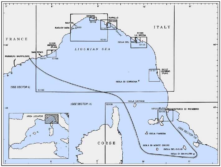
Plan. – The coast described in this sector comprises of the N and E shores of the Ligurian Sea and Arcipelago Toscano, which lies mainly in the N part of the Tyrrhenian Sea. The descriptive sequence is NE from Ruisseau Saint-Louis (Italian-French border) to Genova, then SE and S to Promontorio di Piombino and Arcipelago Toscano.
General Remarks
10.1 Winds – Weather. – In the Ligurian Sea and Golfe di Genova, the prevailing wind is from the NW practically all year. However, locally along the coast, there is some variation due to the land configuration. In the N part of the Tyrrhenian Sea, the most prevalent winds are from the SE, W, and NW.
Fog is not common and the little that does set in usually occurs during the early morning and lifts shortly after sunrise.
Tides – Currents. – Tides, tidal currents, and surface currents within this area are generally negligible. The greatest fluctuation of water level is caused by wind action and atmospheric pressure gradients.
Regulations. – Tanker vessels of 1,600 grt and over entering or leaving Italian ports and carrying, or with uncleaned tanks which last carried, petroleum, gas, or chemical products should report to a shore station before entering Italian territorial waters off Italian ports. For further details, see Pub. 140, Sailing Directions (Planning Guide) North Atlantic Ocean, Baltic Sea, North Sea, and the Mediterranean Sea.
Caution. – Submarines are reported to exercise frequently in the E part of the Golfe di Genova.
Ruisseau Saint-Louis (Italian-French Border) to San Remo
10.2 Ruisseau Saint-Louis (Fiume San Luigi) (43°47'N, 7°32'E) marks the border between France and Italy. Punta Garavano, located 0.5 mile ESE of the mouth, is high, rocky, and pointed. The prominent village of Grimaldi is situated close N of the point and is surrounded by olive trees.
Capo Mortola (43°47'N, 7°33'E), located 1.2 miles ESE of the river mouth, can be recognized by Villa Hambury, a reddish building surmounted by a prominent tower, standing 0.2 mile N of it.
A fresh water spring lies in a depth of 14m, about 300m SSW of the cape. With a calm sea, the boiling action of this spring can be seen on the surface. The spring is marked by a lighted buoy.
A rocky spit extends about 0.3 mile S from the cape and is marked by a buoy.
The cape offers moderate shelter from SW winds and vessels can anchor, in depths of 7 to 10m, sand, good holding ground, E of Villa Hambury.
Ventimiglia, a town, is situated at the mouth of the Fiume Roja, 2.7 miles E of Capo Mortola. In its W part, the belfry of the cathedral and San Spirito Hospital, a long building, are prominent from seaward. Two prominent bridges stand within 0.4 mile of the river mouth.
During E and NE winds, good anchorage is available, in a depth of 17m, good holding ground, about 0.5 mile S of the mouth of the Fiume Roja. However, this roadstead is untenable during S winds.
Along this stretch of coast between Capo Mortola and San Remo, 9 miles ENE, the onset of winds from seaward is generally indicated by clouds along the mountains, a dark horizon, and a swell.
Capo Saint Ampeglio, located 3 miles ESE of the mouth of Fiume Roja, appears low and rises gradually to a summit which is covered with vegetation.
Bordighera, a resort, is situated in the vicinity of the cape. The old part of the town, with a prominent belfry, stands close N of the cape. The modern part of the town extends along the beach to the W of the cape. A conspicuous casino building, with a church close W of it, stands on an embankment, close within the cape. A small craft harbor, formed by two moles, lies close NE of the cape. It has a depth of 3.5m, but is subject to silting. The port monitors VHF channels 16 and 25.
Ospedaletti, a small village, is situated 2.5 miles NE Capo Saint Ampeglio. It can easily be identified by its casino, a conspicuous yellow building, which is surmounted by three cupolas.
10.3 Capo Nero (43°48'N, 7°44'E), located 3 miles ENE of Capo Saint Ampeglio, is rounded and yellowish. Villa Anfossi, a red two-story building, stands on its summit. Numerous buildings stand close to the shore in this vicinity.
A hovercraft terminal is situated 1 mile NE of the cape. The arrival or departure of a hovercraft is indicated by a red flag displayed at the terminal and by the sounding of a siren.
Caution. – Less water than charted has been reported off the small harbor at Bordighera.
A submarine pipeline extends 0.6 mile seaward from a point on the shore, 1 mile W of Capo Saint Ampeglio.
A submarine pipeline extends ENE along the coast from a position lying 0.9 mile NE of Capo Saint Ampeglio to a position lying 0.6 mile WNW of Capo Nero. Anchoring in the vicinity of this pipeline is prohibited.
World Port Index No. 39360
10.4 The port of San Remo lies 2.5 miles ENE of Capo Nero and is a winter tourist resort.
Winds – Weather. – Winds from the E can cause a heavy surf in the harbor, making berthing difficult.
Depths – Limitations. – The harbor is protected by two breakwaters and has depths of 10 to 11m in the entrance. An extensive yacht marina is situated in the E part of the harbor. A commercial quay, situated in the W part of the harbor, is 100m long and has a depth of 4.6m alongside. Vessels up to 100m in length and 4.3m draft can be accommodated.
Aspect. – The town is dominated by Monte Bignone, 1,298m high, standing 3 miles N of it. This hill can be recognized by its dark color and by a prominent building which surmounts a ridge close E of the peak.
The conspicuous cathedral of Madonna della Costra, surmounted by a white cupola and two low belfries, stands on the summit of a hill on which the old part of the town is situated. This cathedral is generally floodlit at night.
The new part of the town extends along the coast and includes numerous large hotels and villas. A prominent radio mast, 76m high, stands near the shore at the E end of the town.
Anchorage. – Vessels can anchor, in a depth of 12m, sand, close E of the harbor entrance. The holding ground is good, but anchorage is not advisable with strong S winds.
Directions. – The approach channel leads NW from a point 0.3 mile SE of the entrance. Vessel entering and leaving port should keep to the starboard side of the channel. The port monitors VHF channels 15 and 16.
Caution. – A dangerous wreck lies about 0.4 mile E of the harbor entrance. An outfall pipeline extends 0.7 mile seaward from a point on the shore, 0.5 mile W of the harbor entrance. An outfall pipeline extends 0.2 mile seaward from a point on the shore, 0.5 mile E of the harbor entrance. An outfall pipeline extends 0.5 mile seaward from a point on the shore, 0.8 mile E of the harbor entrance. It is reported (1996) that three new breakwaters were under construction outside the port.
10.5 Capo Verde (Cape dell’ Arma) (43°49'N, 7°50'E), a rounded cape, is located 2.3 miles E of San Remo. It rises to a hill, 114m high, which is marked by a prominent succession of cultivated terraces. The small white sanctuary of Nostra Signora della Guardia, surrounded by trees, stands on the summit of this hill. A light is shown from a structure, 15m high, standing on the cape.
Torre dell’ Arma, an ancient square tower, stands on the coast, 1 mile NE of Capo Verde. A breakwater jetty, 68m long, extends E from a point on the shore, close to this tower.
The village of Arma di Taggia extends along the coast between the tower and the mouth of the Fiumara di Taggia, 0.8 mile ENE. Numerous prominent chimneys stand in the village, and a yacht marina lies within the entrance of the river. A pleasure craft marina is reported (1989) to be under construction at a point along the shore, about 2 miles ENE of the river mouth.
10.6 Capo San Lorenzo (43°51'N, 7°58'E), located 4.6 miles ENE of the mouth of the Fiumara di Taggia, is low and sandy. A prominent church with a belfry, which is hidden from the W by modern buildings, stands near the coast in the vicinity of the cape. A prominent sanitarium, fronted by a long veranda, stands 0.7 mile W of the cape.
The conspicuous village of Poggi, in which there are two prominent belfries, is situated on a hill, 149m high, 1.5 miles NE of the cape.
Caution. – An outfall pipeline extends 0.3 mile SE from a point on the shore, close to Torre dell’ Arma.
A submarine pipeline lies about 0.5 mile offshore between Capo Verde (Cape dell’ Arma) and Imperia. Anchoring within 1 mile of this pipeline is prohibited.
A dangerous wreck lies 4 miles E of Capo Verde.
World Port Index No. 39370
10.7 The port of Imperia consists of Imperia Ponente (formerly Porto Maurizio) and Imperia Levante (formerly Oneglia).
Port of Imperia Home Page http://www.guardiacostiera.it/imperia
Winds – Weather. – Strong SE and E winds cause a heavy surf in the harbor and affect the water level.
Depths – Limitations. – The harbor basin at Imperia Ponente, on the W side of the port, is protected by two breakwaters. An extensive marina is situated in the N part. The commercial quay is 280m long with a depth of 6.8m alongside. Vessels up to 110m in length and 6m draft can be accommdated.
The harbor basin at Imperia Levante, on the E side of the port, is protected by two breakwaters. The commercial quays are 200m long, with a depth of 8.5m alongside, and 350m long, with a depth of 6.7m alongside. Vessels up to 10,000 dwt, 160m in length, and 8m draft can be accommodated.
Aspect. – Imperia Ponente (Porto Maurizio), a small town, is situated on a rounded hill which rises close N of Punta Chiappe, at the W side of the port. Imperia Levante (Oneglia) stands on a plain close E of the mouth of the Torrente Impero, at the E side of the port.
The prominent monastery of Santa Chiarra, with a long row of arches, stands close N of Punta Chiappe. Imperia Ponente Cathedral stands on the summit of a hill, 0.2 mile N of Punta Chiappe. It is a prominent light-colored building with a conspicuous dome flanked by towers with cupolas. This dome is hidden from the SW by other buildings.
A prominent group of chimneys is situated at the W end of Imperia Levante. A prominent town hall building, four stories with a square tower, stands midway between Imperia Ponente and Imperia Levante.
Pilotage. – Pilotage is compulsory for vessels over 500 grt. Pilots can be contacted on VHF channel 11, 12, or 16 and generally board about 1 mile SE of the harbor entrance. Pilotage is advised for all vessels without local knowledge.
Vessels entering have priority over vessels leaving.
Regulations. – Vessels carrying or which have carried petroleum gas or chemical products are prohibited from navigating within the immediate area of the combined port.
Anchorage. – Vessels can anchor, in depths of 11 to 13m, sand, good holding ground, about 0.2 mile NE of the head of the S breakwater at Imperia di Ponente.
Anchorage Zone A is a circle, with of radius 500m, centered on position 43°52.7'N, 8°03.0'E Anchorage Zone B is a circle, with of radius 500m, centered on position 43°52.1'N, 8°01.6'E
Caution. – A submarine pipeline extends 1.2 miles seaward from the mouth of Torrente Impero. An anchoring and fishing prohibited area, the limits of which are shown on the chart, lies in the vicinity of this pipeline.
Several trawling prohibited areas lie in the approaches to the harbor and may best be seen on the chart.
Between mid-April and the end of October, an area lying N of a line joining the heads of the inner breakwaters at both harbors is reserved for water-skiing in daylight hours. This area is generally marked by buoys and navigating, anchoring, and fishing are prohibited within it.
10.8 Capo Berta (43°54'N, 8°05'E), located 1.5 miles E of the E basin at Imperia, is rounded and bare of vegetation on its lower part. When this cape is enveloped in cloud, SE winds can be expected.
Torre Alpicella stands on the summit of a hill, 267m high, 0.5 mile WSW of the cape.
Diano Marina, a village, is situated close N of Capo Berta. It can be recognized by the tall belfry of the church which has a small red dome. Diano Castello is situated 1.2 mile NW of Diano Marina. This prominent village can be identified by a white church with a large convent close S of it. Picco d’Evigno, 989m high, stands NNW of Diano Castello and is conspicuous.
Anchorage may be obtained off Diano Marina. A good berth lies, in a depth of 15m, sand, about 0.5 mile ESE of the village. Small vessels may anchor closer to the shore, in a depth of 6m.
Capo Cervo, located 2.8 miles ENE of Capo Berta, is rocky and precipitous. A prominent yellow house, with a red roof, stands on the cape and is flanked by two gray buildings.
The village of Cervo, situated close W of the cape, is easily recognized by the houses which are grouped around its church on the slope of a coastal hill. The beach fronting the village is crossed by a stone railway bridge with six arches.
The village of Rollo, with a conspicuous belfry, is situated on a hill 1 mile N of Capo Cervo and is prominent from seaward.
Caution. – An anchoring, fishing, and diving prohibited area, the limits of which are shown on the chart, is situated in the vicinity of an historic wreck lying 1.5 miles ESE of Diano Marina.
An outfall extends 0.6 mile SE from Capo Berta. Work is in progress (2006) to repair the coastal road damaged by landslides in the vicinity of Capo Berta.
10.9 Capo Mele (43°57'N, 8°10'E), located 2.7 miles NE of Capo Cervo, is high and rounded. A light is shown from a prominent tower with a dwelling, 25m high, standing on the cape. A signal station surmounts the summit of the cape.
Currents off this cape are strong and usually set SW. It is reported locally that they attain their greatest velocity between 1 mile and 2 miles offshore. However, at a distance of about 350m from the coast, there may be SW or even a counter-current at times. The currents are generally not dangerous and tend to set away from the coast.
Marina di Andora, a village, extends along the shore close W the cape and contains some prominent red buildings. Anchorage is available, in a depth of 13m, sand, about 0.4 mile SE of this village.
The coast between Capo Mele and Capo Santa Croce, 3.7 miles NNE, forms a wide bay. The shore is high and rocky for 1 mile and then it becomes low and sandy. The village of Laigueglio, situated 1.5 miles NNW of Capo Mele, has a prominent church with twin belfries and a white facade; only the upper part of the facade is visible from seaward.
Alassio, a resort town, extends along the beach, 1 mile S of Capo Santa Croce. Three churches stand in this town and the N and E ones have prominent belfries. The conspicuous sanctuary of Madonna Della Guardia, a large building, stands on the crest of a ridge, 1.5 miles NW of the town. A T-headed pier projects 160m from the beach abreast the E church. It has a depth of 3m and is used by small craft in good weather.
Capo Santa Croce (44°01'N, 8°12'E) is a steep promontory which terminates in a yellowish -colored rocky point. It is surmounted by a small gray chapel near two prominent high -rise buildings.
Caution. – A submarine pipeline extends up to 0.4 mile SE of Capo Santa Croce. Anchoring and fishing are prohibited in the vicinity of this pipeline.
10.10 Porto di Alassio (Luca Ferrari) (44°00'N, 8°10'E), a small harbor, lies on the N side of Capo Santa Croce and is protected from the E by an outer breakwater. Its entrance, which lies between the head of the breakwater and a mole, is 80m wide. There are depths up to 4m in the harbor and extensive facilities for small craft and yachts. The port monitors VHF channel 9.
Monte Bignone, 520m high, stands 1 mile NW of Capo Santa Croce and is prominent.
Capo Lena (44°03'N, 8°14'E), located 2.3 miles NE of Capo Santa Croce, is the SE extremity of a wide tract of low and flat land. It is rounded, sandy, and formed by deposits which are brought down by the Fiume Centa. Depths of less than 10m extend as far as 0.5 mile offshore to the S of the cape and it should be given a wide berth, especially after heavy rains and violent seas which produce changes in the depths near the mouth of the river.
Isola Gallinara lies 1 mile S of the cape. It is 90m high, rocky, and covered with vegetation. A prominent house, surmounted by a tower and surrounded by a wall, stands on the summit of this island.
Albenga, an old town, is situated 0.5 mile inland of Capo Lena. It can be recognized by several high reddish -colored towers, the cathedral, and a conspicuous high -rise building.
Anchorage may be obtained by small vessels, with local knowledge, in a depth of 6m, off the beach abreast this town.
It is reported that should the sky to the S become obscured by heavy cumulus clouds with gray strata, strong S winds may soon be expected.
Caution. – A submarine cable and a submarine pipeline (water) extend between the NW side of Isola Gallinara and the mainland to the NW. Anchoring and fishing are prohibited in the vicinity of this pipeline and cable.
Due to residual ordnance, fishing and diving are prohibited within 500m of Isola Gallinara.
Anchoring and fishing are prohibited in the vicinity of an historic wreck lying 1 mile ENE of Capo Lena.
10.11 Capo di Noli (44°12'N, 8°25'E) is located 12.3 miles NE of Capo Lena. The coast between is dominated by a chain of high mountains. Monte Carmo, 1,390m high, stands 4 miles inland, nearly midway between the two capes.
Ceriale is situated 3 miles N of Capo Lena. This village can be recognized by its modern light-yellow buildings and a tall chimney. Castello Borelli is situated 0.5 mile NNE of Ceriale. This castle stands on the lower seaward slope of Monte Picarro, 281m high, and is surmounted by a conspicuous tall and slender tower. Borghetto Santo Spirito, situated 0.3 mile NNE of the castle, consists of modern buildings and hotels.
Six jetties, each 60m long and 160m apart, extend from the shore at Ceriale and terminate in almost circular platforms. The N platform is submerged and marked by a beacon.
Loano, a town, is situated 5 miles NNE of Capo Lena. It can be identified by the church which has a large and dark cupola surmounted by a statue. Another cupola, lighter and smaller, surmounts the monastery of Monte Carmel which stands 0.3 mile N of the town.
A fishing craft harbor fronts the town and is protected by two breakwaters. Vessels can anchor, in a depth of 18m, about 0.5 mile SE of the town.
Pietra Ligure, another small town, is situated close N of Loano. It can be recognized by the buildings and tall cranes of a shipyard. A church standing in the NE part of the town is also prominent from seaward.
Caution. – Anchoring and fishing are prohibited in a fish haven area, the limits of which are shown on the chart, lying off Loano.
10.12 Capo di Caprazoppa (44°10'N, 8°20'E), located 2.5 miles ENE of Pietra Ligure, is a rocky point, 82m high, which rises steeply from the sea. A prominent ruined tower, with a white villa nearby, stands on its summit. Monte Caprazoppa, 291m high, stands close W of the cape and is a good landmark because of the numerous red patches on its S slopes. In addition, a large and light-colored patch lies on its SE side and is very prominent from seaward.
The towns of Finalmarina, Finalpia, and Finalborgo form the municipality of Finale Ligure and present an almost unbroken line of buildings between Capo di Caprazoppa and Punta San Donato, 1.5 miles ENE. Punta San Donato is a small rocky projection which rises perpendicularly from the sea and is surmounted by an ancient tower.
The small harbor of Finale Ligure is formed by a breakwater, which extends NE from Punta San Donato, and has extensive facilities for yachts. The harbor monitors VHF channels 15 and 16. Punta Crena, located close SSW of Capo di Noli, is steep, rocky, and surmounted by a prominent tower.
Capo di Noli (44°12'N, 8°25'E), high and rocky, rises steeply from the sea. It is a yellowish -gray color and is dotted with vegetation. Monte Capo di Noli, 276m high, stands close SW of the cape and is prominent. The town of Noli is situated 0.5 mile N of the cape. La Rocca, an old castle with a high tower, stands on a steep and isolated hill, 121m high, close N of the town.
Vessels can obtain shelter from W winds in the bight lying between the cape and the town of Noli.
Spotorno, a town, is situated 2 miles N of Capo di Noli. The yellow belfry of its church rises above the houses and is prominent. A large hotel, with a large veranda, is situated close NE of the town and is prominent from seaward. An old fort stands on a hill, close NW of the town. A dangerous wreck lies close off this town.
Punta del Maiolo, located 1 mile NE of Spotorno, is wooded. It can be identified by Torre di Ere which stands on the summit of a hill, 127m high, 1.7 miles NE of the point. This prominent tower is square and has its upper part in ruins.
Isola di Bergeggi, 64m high, lies 1.2 miles SE of Punta del Maiolo. A ruined fort stands on the summit of this islet. From the S or SE, the islet is difficult to distinguish against the coastal background.
Capo di Vado (44°15'N, 8°27'E), located 1.2 miles NNE of Punta del Maiolo, has several large stone quarries on its E side which give it a whitish appearance. Its summit, 161m high, is surmounted by the ruins of Forte di Stefano. A light is shown from a tower attached to a dwelling, 34m high, standing on the cape.
Rada di Vado (Quiliano) (44°16'N, 8°26'E)
World Port Index No. 39420
10.13 The port of Rada di Vado consists of an open roadstead, a harbor, and an offshore pipeline terminal.
Winds – Weather. – During the winter, winds from the NE quadrant blow frequently and violently, sometimes preventing the berthing of vessels. Strong SW winds can also suspend berthing operations.
Tides – Currents. – The current is generally weak and usually sets SW with an inshore countercurrent. When this countercurrent sets in the opposite direction, it is sometimes strong enough to make berthing difficult and it also indicates that SE winds can be expected.
Depths – Limitations. – The Sarpom Offshore Terminal Berth, formed by seven mooring buoys, lies in a depth of 35m, 1.1 miles NNE of Capo di Vado. Two submarine pipelines extend WNW from the berth to the shore at the mouth of Torrente Quiliano. Tankers of 50,000 to 250,000 dwt can be handled. The largest vessel that can be accommodated is 351m in length and 316,000 dwt.
Porto di Capo di Vado, a harbor basin, is protected from the E by Molo di Sopraflutto, a main breakwater, which extends 0.4 mile NNW from the cape. This basin has 900m of total berthing space with depths of 10 to 15m alongside. There are facilities for container, ro-ro, and reefer vessels up to 60,000 dwt.
Six piers extend from the shore at Rada di Vado. Five of these piers, which are described from S to N, have commercial berthing facilities and one pier (Pontile Enel) is used only as a seawater intake.
Pier San Raffaele, a bulk cargo pier, is 450m long and has two berths. The N berth, 128m long, has a depth of 9.1m alongside and can handle vessels up to 30,000 dwt. The S berth, 160m long, has a depth of 12.5m alongside and can handle vessels up to 50,000 dwt, 220m in length, and 12.3m draft.
Pier Pontile Esso, an oil pier, is 350m long and has a depth of 9m alongside the berth at its head.
Pier Agip Agrimont, an oil pier, is 700m long and has a depth of 10m alongside the berth at its head.
Pier Industria Italiana, an oil pier, is 420m long and has a depth of 9.4m alongside the berth at its head. Vessels carrying sulfuric acid may also be handled here.
Pier Isa, an oil pier, is 435m long and has a depth of 9.4m alongside the berth at its head.
Aspect. – The port is backed by a chain of mountains which are covered with vegetation. The conspicuous sanctuary of Madonna del Monte, with a belfry and cupola, stands on the summit of a hill, 162m high, 2.3 miles NNW of Capo di Vado.
From seaward, the inhabited districts along the shore appear as one single line of houses. The slender belfry of the cathedral standing in the center of Vado Ligure is conspicuous. Forte di Vado, situated close NW of Capo di Vado, is prominent from seaward and well preserved. A prominent church, with a belfry and a conical cupola, stands in the village of Zinola. A prominent church, with a yellow belfry and a cupola, stands at Legino.
Several lighted ranges, shown when vessels are expected, assist berthing at the piers.
Pilotage. – Pilotage is compulsory and are supplied from Savona. Pilots can be contacted on VHF channel 13 and generally board about 2 miles off the Savona harbor breakwater. Vessels should send an ETA from the last port of call, then 96 hours, 72 hours, 48 hours, and 24 hours in advance, to Porto di Savona. Any changes in ETA greater than 12 hours should be reported.
Rada di Vado harbor and terminals can be contacted on VHF channels 11, 13, or 16.
Anchorage. – Rada di Vado offers excellent anchorage with good holding ground, but winds from the SE, although rarely violent, do raise a sea.
Vessels awaiting berthing in Rada di Vado may obtain anchorage off Savona or in a designated area, the limits of which are shown on the chart, lying centered about 2 miles NE of Capo di Vado. A pilot is required for anchoring within this designated area.
Caution. – An anchoring, fishing, and stopping prohibited area, the limits of which are shown on the chart, lies 1 mile N, NE, and E of the head of Molo di Sopraflutto.
Two outfall pipelines extend from the shore in the vicinity of the piers at Rado di Vado and may best be seen on the chart. An area of works in progress (2000) is located between Banchina Nord and Pontile San Raffaele.
World Port Index No. 39440
10.14 The port of Savona lies 3.5 miles NE of Porto Capo di Vado. The old part of the city is situated on a plain close SW of the harbor, at the foot of a hill, on which the modern part of the city is rapidly expanding.
Port of Savona Home Page http://www.porto.sv.it
Winds – Weather. – Winds from the NE blow straight into the port, but do not raise a heavy sea. Winds from the E to S send in a swell, but this condition is generally of short duration. Gales from the SE are usually indicated when the water reaches the level of the first step of the Rotonda; this sometimes occurs 24 hours ahead of the storm. This is particularly advantageous, for although the stormy weather already prevails at sea, within the harbor there are usually only slight N winds, if any.
During the period of N winds prior to a gale, the peaks of the mountains are covered with elongated clouds, called Garo.
Tides – Currents. – The tides are negligible, rising only 0.3m at springs. However, the advent of strong onshore winds can increase the rise by as much as 0.6m.
The current off the port sets constantly SW with a velocity which depends on the winds and the strength of the discharges from the neighboring rivers. Its average rate is 1 knot, but under certain conditions it may attain a rate of 2 knots.
 |
Savona |
Depths – Limitations. – The harbor is protected from the SE by Nuovo Molo Frangiflutti, an outer breakwater, which extends 0.7 mile NE from Punta San Erasmo. Molo Frangiflutti, which extends NE, lies 275m NW of the outer breakwater and divides the harbor into two main parts.
Darsena Vecchia, a basin, is entered at the W end of the N part. It has 480m of total berthing space with depths of 4.6 to 8.5m alongside.
Darsena Nuova, a basin, is entered on the S side of the inner part. It has 794m of total berthing space with depths of 6.3 to 9m alongside.
Calata Paola Boselli, a quay, lies at the S side of the inner part. It has 525m of total berthing space with depths of 7.5 to 8.5m alongside.
Darsena Alto Fondale, which forms the outer part, has 450m of total berthing space with a depth of 15m alongside. Vessels up to 14m draft can be accommodated.
There are facilities for container, ro-ro, and bulk vessels.
Aspect. – Conspicuous landmarks include a chimney standing S of the harbor; the sanctuary of Madonna degli Angeli, with a wide belfry, standing by itself on the slope of a hill, close NW of the city; a high -rise building which stands in the harbor area and overlooks the city; and the silos situated on Calata Paolo Boselli.
The orange lighting of the harbor area can be seen from a great distance and greatly facilitates night approaches.
Pilotage. – Pilotage is compulsory for vessels over 500 grt. Pilots can be contacted on VHF channel 13 and usually board between 0.5 and 1 mile from the harbor entrance.
Vessels 500 grt and less should contact the pilot station for instructions.
There is a maximum speed limit of 6 knots within the harbor.
This station also supplies pilots for Rada di Vado.
Anchorage. – Anchorage, sheltered from the SW through N to the NE, is available, in depths of 12 to 22m, sand, good holding ground, in Rada di Albissola, an area lying 1.5 miles NE of the harbor entrance.
A designated anchorage area, the limits of which are shown on the chart, lies centered 1 mile S of the harbor entrance. Vessels are advised not to anchor in this area without the aid of a pilot.
Anchorage can also be taken in the designated area at Rada di Vado.
Two deep water anchorage berths lie 1.5 to 2 miles SSE of Savona.
Caution. – An anchoring, stopping, and fishing prohibited area, the limits of which are shown on the chart, extends up to 0.5 mile from the harbor entrance.
An anchoring prohibited area, the limits of which are shown on the chart, extends up to 1 mile N, NE, E, and SE of the harbor entrance.
Several outfall pipelines, which may best be seen on the chart, extend from the shore NW of the harbor entrance and from the vicinity of Punta San Erasmo.
A area of reclamation works (2000) exists around the Molo Frangiflutti.
10.15 Albisola Marina (44°20'N, 8°30'E) a small town, stands 1.5 miles NE of Savona. It is easily identified by a railroad station, a railroad bridge, and a church with a statue which are all prominent.
Punta Celle, located 1.4 miles ENE of Albissola Marina, terminates in a very steep and rocky mass which is surmounted by a pine grove.
Celle Ligure, a small town, is situated close NNE of the point. A beach at the center of the town is interrupted by a rocky elevation, almost sheer to the sea, which has arches and columns on it. A prominent hotel stands close NE of the town.
Punta dell’ Omo, located 1 mile ENE of Celle Ligure, can be identified by the numerous light-colored and large buildings in its vicinity. La Crocetta, a small church with a pointed belfry, stands on the summit of a hill, 294m high, 1 mile NNW of the point and is easy to distinguish.
Varazze (44°22'N, 8°35'E), a town, is situated 0.9 mile NE of Punta dell’ Omo. The conspicuous Collegio Don Bosco, a yellow four-story building, stands at the back and overlooks the town. The white building of a shipyard is situated near the W end of the town and is prominent. Monte Grosso, 402m high, stands 1 mile NE of the town and is covered by dark green vegetation. It can be recognized by the small chapel of Guardia di Varazze, which in clear weather appears from seaward as a white point on a dark peak.
A small craft harbor, protected by a breakwater, lies close N of Punta dell’ Aspera and close W of the town.
During periods of strong NE winds along the entire coast, it is reported that very weak winds, or a calm, will be experienced in the immediate vicinity of Varazze.
Vessels with local knowledge can anchor off the town, in a depth of 11m, sand.
The site of a historic wreck and its circular prohibited area is located 0.7 mile SE of Punta dell’Aspera.
10.16 Punta d’Invrea (44°20'N, 8°37'E), located 2.4 miles NE of Varazze, can be identified by a castle, visible among the trees, standing at the top of a steep hill, close N of it.
Cogoleto, a small town, is situated 1.5 miles NE of the point and has a conspicuous white church standing on the beach at its E end. The conspicuous buildings of a hospital, some light-colored and others dark red, stand on a plateau, 193m high, 1 mile WNW of the town.
Capo Arenzano, located 1.7 miles ENE of Cogoleto, rises steeply from the sea to a flat summit on which stand numerous large buildings. A small craft harbor, the entrance of which is partially obstructed by a sand and gravel bank, lies close N of the cape.
A wreck, with a depth of 30m, lies about 1.6 miles SSE of the harbor. An anchoring and fishing prohibited area, with a radius of 0.1 mile, is centered over the wreck.
The town of Arenzano, situated 0.5 mile N of the cape, is dominated by a church, with a prominent bell tower, standing on the slope of a hill behind it. Another prominent church stands close W of the town and rises high among the trees.
Punta della Chiappa is located 2 miles NE of Capo Arenzano. A pink three-story building, surmounted by a squat tower, stands on the point and aids in its identification. Scoglio Nave, a low and dark-colored rock, lies close off the point, but is difficult to distinguish against the coastal background.
Vessels can anchor, in a depth of 13m, sand and weed, E of the large church in Arenzano. The holding ground is good and small vessels can obtain shelter from W and SW winds.
Voltri (44°26'N, 8°45'E) is situated on the E side of Torrente Cerusa, 3 miles NE of Arenzano. It forms the W end of the built up area which extends W from Genova. A prominent belfry, with a cupola, stands near the shore between Torrente Cerusa and Torrente Leiro, which divides the town in half. A prominent church, with a white and red belfry, stands on a hill, 159m high, behind the town.
Torrente Cerusa and Torrente Leiro bring down considerable deposits which form temporary banks off their mouths. These banks are usually dispersed along the coast during heavy weather and cause the beaches to extend further seaward.
Pra (44°26'N, 8°47'E) is situated 1.5 miles E of Voltri. This town may be recognized by a distinctive building standing on the heights behind it. The building consists of two blocks, the higher one being surmounted by a cylindrical tower.
World Port Index No. 39470
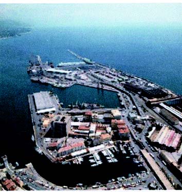
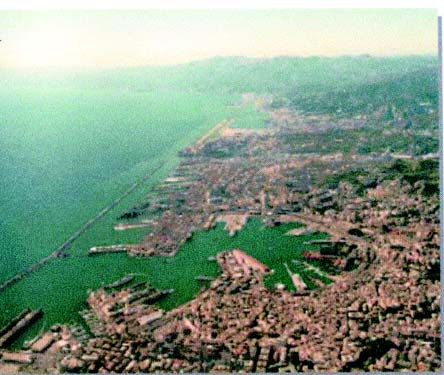
10.17 Genova, the principal commercial port of Italy, lies centered 19 miles NE of Savona and also has extensive ship-repair facilities.
Winds – Weather. – The prevailing winds in summer are from the SE (Scirocco) and the strongest winds are from the SW (Libeccio). The latter seldom reach the port with any great force. However, when they do, these winds are quite violent and cause a high swell in the harbor.
Port of Genova Home Page http://www.porto.genova.it
Winds from the N to NW, especially in winter, descend from the mountains in violent squalls and frequently bring rain, sleet, or snow. They usually reach their maximum force at a distance of 1 to 2 miles offshore where they raise heavy seas. Gales are most frequent in February and least frequent in July.
Tides – Currents. – The tides are negligible with a rise of only about 0.3m at springs. However, changes in the water level caused by winds and atmospheric pressure variations can exceed those of the tide. Winds from the S tend to raise the level and winds from the N tend to lower the level.
Tidal currents within the harbor are negligible. Outside the harbor, the current generally sets W at an average rate of 0.7 knot, increasing with SE winds to about 2 knots.
Depths – Limitations. – The Multedo Offshore Oil Terminal is situated off the W end of the port and consists of a platform and a single buoy mooring.
The single mooring platform lies in a depth of 50m, 1 mile SW of the W end of the airport at Genova. A submarine pipeline extends NE from the platform towards the shore. The berth at this platform can handle tankers up to 500,000 dwt.
The single buoy mooring (SBM) lies in a depth of 65m, about 1 mile ESE of the platform. A submarine pipeline extends NW from this buoy towards the entrance to the inner oil harbor. The berth at this buoy can handle tankers up to 270,000 dwt, 350m in length, 53m beam, and 20m draft.
The W part of the main port consists of Porto Petroli di Multedo, an inner oil terminal, the Ansaldo Shipyards, and the Cristoforo Colombo Airport. A steel works, with storage areas, is situated close E of the airport.
The E part of the port consists of numerous basins with the central part of Genova arranged like an amphitheater on the slopes of the mountains which encircle it.
The main harbor is protected from the S by a detached breakwater nearly 3 miles long. It is known as Diga Foranea, in the W part, and Molo Duca di Galliera, in the E part.
The entrance channel and turning basin at Port Petroli di Multedo have depths of 15.5m. This inner oil terminal has four piers projecting from the N side and a total of eleven berths. Tankers up to 130,000 dwt, 259m in length, and 14m draft can be accommodated.
The W harbor entrance, which leads S of the W extremity of Diga Foranea, has a least charted depth of 13.5m. Use of this entrance is usually restricted to vessels berthing at the steel works basin. This basin, which has 500m of berthing space depths of 12.1 to 13.4m alongside, is used only by vessels with cargoes of coal or iron for the steel works. Vessels with a masthead height exceeding 31m are not permitted to berth at the steel works.
The E and main entrance to the harbor lies between the E extremity of Mola Duca di Galliera and the head of Molo di Sottoflutto, which extends SSW.
Avamporto is entered from the E entrance and comprises the area between Molo Duca di Galliera and Molo Giano. This basin is mostly used by vessels awaiting a berth.
 |
Port of Genova |
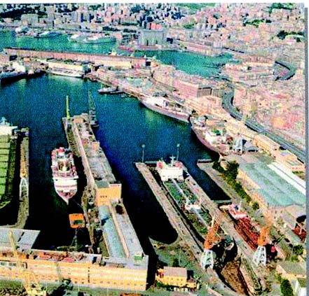
Bacino delle Grazie lies N of Avamporto and is used mainly for repairs. Calata Olii Minerali, at the S part of the W side of this basin, has 474m of berthing space and can accommodate vessels up to 11m draft.
Porto Vecchio is entered from Bacino delle Grazie and extends W and N to the head of the port. There are depths of 7 to 11m alongside the numerous piers and quays which have facilities for general cargo, ro-ro, automobile ferries, and passenger vessels. A quay, 500m long, with a depth of 14.5m alongside, is used by container vessels.
Bacino della Lanterna lies W of Caleta Olii Minerali. This basin has depths of 12 to 13m with facilities for mineral, oil, coal, and bulk cargo. There is 1,184m of total berthing space and vessels up to 10.5m draft can be accommodated.
Bacino di Sampierdarena extends 1.2 miles WNW of Bacino della Lanterna. There are depths of 8 to 14m alongside the piers which project SSE into this basin and are used for general and bulk cargoes. In addition, a container quay, 1,200m long, has five berths, with depths of 11 to 11.6m alongside.
 |
|
Genova – Bacino delle Grazie |
Aspect. – The municipality of Genova extends from Voltri to Nervi, about 13 miles ESE. The villages and small towns form an unbroken line of buildings along the coast which extend from the shore to the slopes of the mountains in the background. The center of Genova is easily recognized because its populated area extends chiefly inland. At night, the city lights are visible from a great distance to seaward.
The following landmarks are very conspicuous when approaching the harbor:
- The sanctuary of Madonna del Gazzo (44°27'N, 8°51'E) standing on the summit of Bric del Gazzo, 421m high. It can be recognized, even at night, due to its votive light shown on the crest of the mountain.
- The sanctuary of Madonna della Guardia, with a cupola and steeple, standing on the summit, 804m high, of Monte Figogna, 3 miles N of Bric del Gazzo.
- Forte Castellacio (44°26'N, 8°55'E), with two radio towers and a massive reddish tower.
- Forte Quezzi (44°26'N, 8°58'E), a large structure, standing on a hill, 231m high, NE of the city.
- Torre Quezzi, standing isolated 0.3 mile ENE of Forte Quezzi.
- Forte Ratti (44°26'N, 9°00'E), a long and low structure, with a round tower at its NW end.
- Forte Richelieu, surmounted by a cupola, standing 1 mile SSW of Forte Ratti.
- The buildings and lights of Cristoforo Columbo Airport (Genova) situated at the W end of the harbor.
- A huge shed and six chimneys situated at the steel works to the E of the airport.
Approaching the harbor from the E, the following landmarks can also be easily identified:
- Monte Fascie (44°25'N, 9°02'E), 834m high, with a conspicuous white cross standing on the W side of its summit.
- Monte Guigo, with a dense number of houses situated on its slopes, standing 1.5 miles SE of Monte Fascie.
- Monte di San Croce, surmounted by a chapel, standing 1.5 miles ESE of Monte Guigo.
- The steeple of Pieve Ligure standing on the SE slope of Monte di San Croce. The fairway channel leading to the inner oil harbor is marked by lighted buoys.
Lanterna Light is shown from a structure, 76m high, standing 2 miles WNW of the E harbor entrance. A radiobeacon is situated at the light. A signal station is situated close S of the base of the light. Caution is necessary, as this light is reported to be not easily distinguished from the S and the signal station is not visible between the bearings of 010 ° and 024°.
Pilotage. – Pilotage is compulsory for vessels over 500 grt. Pilots can be contacted on VHF channel 10, 12, 14, or 16 and usually board about 1 mile SE or SW of the harbor entrances or from the offshore terminals, as appropriate.
 |
Genova Pilot Boat |
Regulations. – Vessels carrying polluting or dangerous cargo must report to the harbormaster at least 24 hours prior to entering Italian territorial waters. These vessels must maintain VHF contact when within range.
Approach Zones, the limits of which are shown on the chart, lie in the vicinity of the approach channels leading to the E harbor entrance and to the inner oil harbor. Within these zones, vessels must keep to the starboard side of the fairway. Vessels crossing these zones must do so at right angles to the line of the channel and in the least time practicable.
A recognition and reporting zone has been established, bearing 215° distant 5 miles from Lanterna Light (44° 24.3'N, 8°54.3'E), for vessels unable to find a berth in the harbor. Such vessels should enter the zone and report to the signal station on VHF channel 16 for instructions in order to determine their ETA.
Tankers and vessels carrying dangerous cargo are permitted to anchor in Anchorage Area Bravo or one of the lettered anchorages while awaiting a berth.
In order to establish priorities between vessels leaving or entering port and aircraft taking off or landing at Christoforo Columbo Airport a regulated zone has been established in an area connected by the following positions:
a. 44°25.7'N, 8°45.2'E
b. 44°22.9'N, 8°43.7'E
c. 44°20.6'N, 8°55.0'E
d. 44°23.4'N, 8°56.3'E
Additionally, two way points have been established in the waters leading to the approach channel to the petrochemical harbor (Multedo Oil Port). These points are designated T1 and T2 and are located, as follows:
- T1 – 44°25.2'N, 8°49.5'E
- T2 – 44°24.7'N, 8°48.2'E
Within the regulated area vessels entering the port have priority over aircraft movements. Vessels leaving port must give way to aircraft movements except in cases where the departing vessel has entered the approach channel and has already passed way point T1.
Vessels having an air draft of more than 48m must report to the Harbor Pilots Control Tower and to the Operations Room in the Harbormaster’s Office prior to entering the regulated area or before moving within the area.
When transiting the approach channel to the oil harbor, all oil and gas tankers regardless of air draft and all other vessels with an air draft of more than 14m must make the same reports described above.
Vessels transiting the approach channel to the oil harbor are prohibited from stopping between the rubble breakwater and the head of the airport. Vessels using the Pra-Voltri Canale di Calma must maintain a distance of 50m to 150m from the Digea Foranea of Porto di Voltri.
Anchorage. – Anchorage may be obtained off Genova in the following designated areas, the limits of which are shown on the chart:
- Zone Alpha (44°23'N, 8°45'E) – For vessels proceeding to or from Genova-Voltri.
- Zone Bravo (44°24'N, 8°50'E) – For small tankers proceeding to or from Genova-Multedo.
- Zone Charlie (44°22'N, 8°54'E) and Zone Delta (44°21'N, 9°02'E) – For vessels proceeding to or from Port Vecchio and Sampierdarena.
- Zone Echo (44°22.6'N, 8°51.5'E), Zone Foxtrot (44°22.6'N, 8°52.5'E), and Zone Golf (44°21.7'N, 8°52.2'E) – For tankers over 40,000 grt proceeding to or from Genova-Multedo.
- Zone Hotel (44°23.3'N, 8°51.2'E) and Zone Lima (44°23.4'N, 5°52.0'E) – For tankers proceeding to or from Genova-Multedo between 20,000 and 40,000 grt.
Caution. – Anchoring, stopping, and fishing prohibited areas, the limits of which are indicated on the chart, lie in the vicinity of the harbor entrance channels.
The main harbor has no free-swinging anchorage mooring berths. In addition to numerous alternative Mediterranean mooring berths at quays and moleheads normally used for alongside berthing, there are a considerable number of fixed moorings suitable for lighterage operations in connection with ocean-going vessels.
Numerous unlighted mooring and warping buoys are situated throughout the harbor area. A prohibited area, the limits of which are shown on the chart, has been established in the vicinity of the offshore terminals.
The passage of unauthorized vessels through this area is prohibited.
The inshore area between Voltri and Pra is being reclaimed and developed as a large container and ro-ro terminal with a quay, 1,100m long, and depths up to 15m alongside.
A mole, the head of which is marked by a light, extends 0.3 mile SSE from an area of reclaimed land lying 0.9 mile E of Voltri. A main detached breakwater, about 1.3 miles long, is under construction in this vicinity. It extends SW and WNW from a position 0.7 mile WNW of the W extremity of the airport at Genova.
Many high -speed ferries operate in the harbor area.
10.18 Nervi (44°23'N, 9°02'E), a tourist resort, is situated 4.8 miles ESE of the E entrance to Genova and can be identified by its numerous large hotels and villas. A prominent building, with a small belfry and a cupola, stands on the W side of this town.
The coast between Nervi and Camogli, 5 miles SE, is rocky, indented, and drops steeply to the sea. The town of Bogliasco, situated 1.5 miles E of Nervi, can be identified by a high masonry viaduct. This viaduct has several arches and crosses Torrente del Poggio, a stream in the middle of the town.
Sori, a small town, is situated 1.5 miles ESE of Bogliasco. It can be identified by a concrete railroad viaduct, which crosses the mouth of Torrente di Sori, and by a large highway bridge standing close N of the viaduct. The belfry of a church, which stands close W of the viaduct, is also prominent.
Between Sori and Recco, 1.7 miles SE, there are numerous large houses and villas. The light-colored belfry of Sant’ Appolinare stands at a height of 266m, 0.5 mile E of Sori. The larger belfry of Polanesi stands at a height of 257m, 0.5 mile ESE of the former belfry. Both are very prominent from seaward.
The small church of Sant’ Uberto, with no belfry, stands at a height of 480m, 0.5 mile N of the belfry of Polanesi. A high column, surmounted by a statue of Christ, stands close to it.
Camogli (44°21'N, 9°09'E), an ancient town, is built on the slopes of Monte Esoli and can be easily recognized by its tall houses, one above the other. The prominent sanctuary of Caravaggio, an isolated and low building with a small stumpy belfry, stands on a summit, 615m high, 2 miles NE of the town. A small craft harbor fronts the town and is protected by a breakwater. Vessels, with local knowledge, can anchor off the town, in depths of 16 to 17m, sand, good holding ground, close SW of the head of the breakwater.
Caution. – Several outfall pipelines extend up to 1 mile seaward between Nervi and Camogli and may best be seen on the chart.
An area of foul ground, the limits of which are shown on the chart, lies about 1 mile SW of Camogli.
10.19 Promontorio di Portofino (44°19'N, 9°11'E) is the most prominent of the numerous coastal projections on the NW coast of Italy. Its sides are high, rugged, rocky, and generally steep-to. Monte di Portofino, 610m high, stands in the SW part of the promontory and is surmounted by a disused signal-station. Two radio masts stand 0.3 mile NNE of the summit and are prominent from the E and W, but are obscured from the S.
The village of San Rocco, with a prominent belfry surmounted by a black cupola, stands on a hill, 240m high, 1 mile S of Camogli and is visible from the W.
Punta della Chiappa, located 1.7 miles S of Camogli, forms the SW extremity of the promontory. It is a low, bare, and dark point which is marked by a beacon. Monte Tocco, 427m high, stands 0.5 mile E of the point. Its summit is surmounted by a disused signal station and a signal mast.
The coast between Punta della Chiappa and Punta di Portofino, 3.5 miles ESE, is high, rocky, and steep-to. Cala dell’ Oro and Seno di San Fruttuoso, two small bays, lie 1 mile and 1.3 miles ESE, respectively, of Punta della Chiappa and are separated by a sharp ridge. This ridge terminates in a small rocky promontory, 103m high, on which stands an old tower.
Punta Portofino (44°18'N, 9°13'E), the SE extremity of the promontory, is bare, rocky, and bold. It rises to a hill, 100m high, on which stand two old forts. A pillar stands at the extremity of the point. A light is shown from a structure, 12m high, standing close within the extremity of the point. A prominent statue of the Madonna stands on the slope of the hill, near the light.
Caution. – A wreck lies 0.3 mile ENE of Punta Portofino in position 44°18'03.2''N, 9°13'34.2''E
10.20 Golfo Marconi (44°18'N, 9°15'E) is entered between Punta di Portofino and Chiavari, a town, 4.5 miles ENE. It extends 2.7 miles NNW to Rapello, at the head, and is considered to be the most picturesque in the Italian rivieras. The W side of the gulf, which has many small bays, offers good shelter from winds from the S through N. However, the NE side of the gulf is exposed to S and SW winds.
During the winter, winds from the NW prevail and often blow with great violence. An exceptionally clear atmosphere with serene skies and sparse high clouds above the mountains around Rapallo and Chiavari usually precedes strong NE or NNE winds. In summer, winds from the S prevail and rarely attain great force. When NNW winds, locally called “Provenza,” blow violently, a change of weather can be expected with probable winds from the SE.
The most conspicuous landmarks within the gulf include Convento di Cervara, a long and isolated building, standing 1 mile NNW of Punta di Portofino; Monte Rosa, 612m high, which stands 1.7 miles NE of the head of the gulf and is surmounted by the sanctuary of N. S. di Montallegro; the isolated church of Sant’ Ambroglio, with a white belfry, standing halfway up a hill, between Rapallo and Zoagli; and Colonia Marina di Chivari, a red and white horizontally banded high building, standing near the coast, 0.8 mile WNW of Chiavari.
Caution. – Tankers that have carried or those carrying petroleum or chemical and gas products in bulk are prohibited from navigating within an area extending 6 miles offshore between Punta Carrega on Promontorio di Portofino (44°18'N, 9°11'E) and Punta Baffe (44°14'N, 9°27'E). From October to April, tankers of 650 grt or less are permitted to close the coast to 3 miles within this area.
10.21 Portofino (44°18'N, 9°13'E), a small craft harbor, is entered between Punta del Coppo, located 0.3 mile NW of Punta di Portofino, and the coast, 0.1 mile NW. It is protected from all but NE winds, but even these cause little sea. The town is a tourist resort and contains several prominent hotels and villas.
Punta del Pedale is located 1.4 miles N of Punta di Portofina. Vessels can anchor, in depths off 20 to 30m, mud, off a bight lying S of this point.
Caution. – An outfall pipeline extends 1.1 miles ESE from a point on the shore, close N of Punta del Pedale. Anchoring and fishing with nets are prohibited within a zone of 200m to 400m centered on the pipeline. The 200m zone extends from the shore to the first 500m of the pipeline. The 400m area encompasses the remainder of the pipeline.
Several dangerous wrecks lie between Punta di Portofino and Punta di Pedale and may best be seen on the chart.
An outfall pipeline extends 0.2 mile SE from the N shore in the approaches to Portofino and may best be seen on the chart.
The Portofino Marine Nature Reserve has been established as a restricted area. The area extends 7 miles along the coastline from Punta Cannette (44°20.8'N, 9°09.3'E), rounds Punta della Chiappa (44°19.3'N, 9°08.7'E) and Punta di Portofino (44°17.8'N, 9°13.2'E), and continues N to Punta del Pedale (44°19.2'N, 9°13.0'E). Anchoring, fishing, and unauthorized entry or mooring are prohibited within this area.
10.22 Santa Margherita Ligure (44°20'N, 9°13'E), a small harbor, lies in the SW corner of a small bay, 2 miles N of Punta di Portofino. It fronts the city and is protected by a mole which extends 0.2 mile NE from the coast. The harbor can be contacted on VHF channel 11 or 16 and is accessible to small vessels up to 50m in length and 4.6m draft, but strong winds from SE to SW cause a considerable sea in the vicinity of the berths. Vessels can anchor, in depths of 14 to 15m, sand, fair holding ground, ESE of the head of the mole.
The city appears to be divided into two parts by an old fortress which stands 0.5 mile WSW of Punta Pagana, the NE entrance point of the bay. A church, with a white facade and a tall belfry, stands in the S part of the city and is prominent from seaward. Another prominent church, with twin belfries and a black cupola, stands 0.2 mile N of it.
Villa Spinola, surmounted by a square tower, stands close W of Punta Pagana and The Imperial Hotel, a large building, stands on the wooded slopes, close E of the head of the bay.
The city, a resort, is brightly lighted at night and is visible from a considerable distance to seaward.
Rapallo (44°21'N, 9°14'E), a tourist resort, lies at the head of a small bay in the N part of the gulf. A small harbor, protected by moles, lies close N of Punta Langan, the SW entrance point of the bay. It can be contacted by VHF and consists of a small craft basin and an extensive yacht basin.
The town can be recognized by the casino, a red building, standing close NE of Punta Langan; the Excelsior Hotel, a large building, standing close NW of the casino; and the cathedral standing in the center of the town, 0.5 mile N of Punta Pagana. In addition, the clock tower at St. Michele church, situated 0.2 mile SW of Punta Langan, has been reported to be a good landmark and is illuminated at night.
Anchorage off Rapallo is very exposed and should only be used during good weather. Large vessels may anchor, in depths of 18 to 30m, mud, good holding ground, S of the harbor.
Caution. – An outfall pipeline extends 1.2 miles SSE from the head of the bay. Anchoring and fishing are prohibited in the vicinity of this pipeline.
10.23 San Pantaleo (44°20'N, 9°15'E), a small town, is located 1.2 miles SE of Rapallo and can be identified by a prominent belfry. Zoagli, a village, is situated 0.5 mile SE of the town. A prominent railroad viaduct, with seven arches, crosses a river, close W of this village.
Monte Anchetta, 550m high, stands 1 mile ENE of Zoagli and overlooks this part of the coast. The belfry of Rovereto church can be seen above a triangular patch on the slope of this mountain.
Punta Chiappe is located 1.5 miles SE of Zoagli. The prominent chapel of Madonna della Grazie, a long and low building with a small tower, stands 0.3 mile ENE of this point.
10.24 Chiavari (44°19'N, 9°19'E), an industrial town as well as a resort, is situated on the NW side of the mouth of Torrente Entella. The town is fronted by a small craft harbor which is enclosed by moles. An ancient fortress stands in the center of the town and a prominent convent, with a black cupola surmounted by a small copper dome, is situated near the shore, close E of the harbor.
Lavagna, a small town, stands on the SE side of the mouth of Torrente Entella and appears to be part of Chiavari when seen from seaward. It is dominated by the church of San Stefano, which has a black cupola and a white facade, and is flanked by twin belfries. The town is fronted by an extensive yacht harbor which is protected by two moles. Torre de Controllo, a building with a glass top, stands near the harbor. It is 19m high and very conspicuous.
Caution. – An area of sunken barges, the limits of which are shown on the chart, lies centered 0.5 mile SW of Zoagli. An outfall pipeline extends 0.9 mile SW from a point on the shore, 0.2 mile E of Punta Chiappe. A marine farm, marked by buoys, is located 0.5 mile SSE of Lavagna.
Golfo Marconi to Golfo della Spezia
10.25 Punta di Sestri (44°16'N, 9°23'E), located 3.2 miles SE of Chiavari, is not easily discernible from the NW against the rocky background. This point is the NW extremity of a short, rounded, and wooded peninsula which is joined to the coast by a narrow isthmus. Torre Marconi, a massive and cylindrical tower, stands on the summit of the peninsula which is 40m high. It is visible only from the S and W, being hidden by trees from other directions.
Sestri Levante (44°16'N, 9°23'E), a town, is situated partly on the peninsula and partly on a small plain at the mouth of Torrente Gromolo. The belfry of San Stefano church, a red building, which stands out against the wooded background, and the belfry of San Bernardo, which is small and pointed, are situated 1 mile ENE and 1.5 miles NE, respectively, of Punta di Sestri.
A harbor, used by small craft, is formed by a mole, quayed on its E side, which extends 265m NNW and N from Punta di Sestri. Anchorage is available, in depths of 11 to 13m, mud, close NW of the head of the mole. Small vessels can anchor closer inshore, in a depth of 9m, E of the mole. Local knowledge is advised as the depths in this vicinity are constantly changing because of deposits brought down by Torrente Gromolo.
Punta Manara, located 1.5 miles SE of Punta di Sestri, is bold and cliffy. It rises close inland to the summit of Monte Castello, which is 265m high and surmounted by a prominent building.
Vessels can anchor in the bay lying E of Punta Manara. There is good holding ground, in a depth of 9m, sand, about 0.2 mile from the head of the bay clear of the charted outfall.
Punta Baffe is located 1.8 miles ESE of Punta Manara. A prominent tower stands on the slope of a hill, 0.3 mile N of this point. Monte Pu, 1,001m high, stands 5 miles NE of the point and can be identified by its bare, rounded, and light-colored summit which rises above the densely wooded slopes.
10.26 Moneglia (44°14'N, 9°29'E), a village, is situated on the NE shore of a small bay, 2 miles E of Punta Baffe. The prominent church of Santa Croce, with a slender belfry, stands at its SE end. A railway crosses two prominent viaducts, with several arches, which stand in the vicinity of the village.
Scoglio Pietra Stella, a rocky patch, lies about 200m offshore, S of Santa Croce church. It is reported to be awash in places.
The village of Lemeglio is situated on a hill, 0.5 mile SE of Moneglia; its church and steeple are very prominent from seaward.
Monte Pastorelli, 149m high, is the summit of a rounded headland located 8 miles ESE of Punta Manara. This headland terminates in Punta di Monte Grosso, at the W side, and in Punta della Madonna, at the S side. The latter point is bare, rocky, and surmounted by a small chapel with an arched porch.
Bonassola, a village, stands at the head of a small bay which is entered between Punta della Madonna and Punta Levanto, 0.5 mile ESE. The latter point is formed by the W extremity of a hill, 196m high. The village is situated between two streams and is fronted by a tall railway embankment.
Caution. – Several wrecks, some dangerous, lie off this stretch of coast and may best be seen on the chart.
A wreck lies about 1 mile off the coast at Bonassola. It is sunk in depths of 40 to 44m and is reported to contain ammunition.
10.27 Levanto (44°10'N, 9°37'E), an ancient town, is situated at the head of a bay, 1.5 miles SE of Bonassola. It is fronted by a sandy beach and backed by hills in the form of an amphitheater. La Torre, a battlement structure, stands on a steep rocky eminence, near the SE end of the beach. Casino Municipale, a prominent building with porticos at its base, is situated on the beach.
Secca del Peria, a rocky and shallow shoal area, lies about 0.2 mile offshore, 0.5 mile W of Levanto. Depths of 10 to 14m lie in the passage between this shoal area and the shore.
A small craft harbor, protected by two moles, lies at the N side of the bay.
Punta del Mesco (44°08'N, 9°38'E) is covered by thick vegetation and is faced with bare, rugged cliffs. A disused signal station stands 0.3 mile N of the point.
The area between Punta del Mesco and Capo di Monte Negro, 5 miles SE, is known as Le Cinq Terre and is noted for its wine production. It includes, from N to S, the villages of Monterosso al Mare, Vernazza, Corniglia, Manarola, and Riomaggiore. Several small private boat harbors lie within the bays along this stretch of the coast.
Monterosso al Mare is situated at the head of a bay which is entered between Punta del Mesco and Punta Corone, 1.2 miles ENE. This latter point is rocky and surmounted by a white pillar. The village stands on a rocky spur which divides a wide beach into two parts. A white villa, surmounted by a small tower, stands on a small rocky spur at the W end of the beach. Vessels can anchor, in a depth of 20m, off the W part of the beach.
The white church and belfry of San Bernardino, standing 3 miles E of Punta del Mesco, are prominent. Vernazza is situated along the shores of a cove, 1.5 miles SE of Monterosso al Mare.
The village of Corniglia is situated on the top of a promontory, 96m high, which has steep and rugged sides. It can be recognized by a prominent white and spired belfry. Manarola is situated on a rocky point, and Riomaggiore is situated at the mouth of a narrow valley.
Capo di Monte Negro can be easily recognized by the sanctuary of Madonna di Monte Negro, with its prominent belfry and cupola, standing 0.5 mile NE of its seaward extremity.
10.28 Scoglio Ferale (44°04'N, 9°47'E), a conical rock, lies 230m offshore, 2.3 miles SE of Capo di Monte Negro. A white cross stands on its summit and a red pillar stands at its foot. This rock is connected to the coast by a rocky ridge. It is darker than the coast behind it and is easily recognizable when seen from the NW or SE.
Punta del Persico, located 1 mile WSW of Scoglio Ferale, is reddish -colored. A prominent light-colored house, with a tower, stands halfway up the hill behind this point.
Between Punta del Persico and Punta San Pietro, 1.7 miles SE, the rocky coast rises nearly vertically to a considerable height. Punta della Castellana, 510m high, stands 0.7 mile E of Punta del Persico and is surmounted by a fort. Monte Muzzerone, 327m high, stands 0.6 mile NNW of Punta San Pietro and is surmounted by a fort. An old prominent church is situated on Punta San Pietro and the ruins of a large tower stand on higher ground behind it.
10.29 Isola Palmaria (44°02'N, 9°51'E), 204m high, is formed by rock which appears to consist of wide parallel strata, alternately light and dark-colored. A prominent signal station, with a lattice mast close by, stands on the summit of the island.
Vessels entering or leaving Golfo della Spezia are required to identify themselves by VHF to this signal station. The narrow passage leading between Punta San Pietro and Isola Palmaria is navigable only by small craft. Isola del Tino (44°01'N, 9°51'E) lies close S of Isola Palmaria and is covered on its E side by a dark and thickly-wooded area. Its W side is composed of light-colored perpendicular cliffs. A light is shown from a structure, 24m high, standing on the summit of the island. A racon is situated at the light.
Il Tinetto, 18m high, lies close S of Isola del Tino and is connected to it by a ridge of rocks, some of which are above water. Dangers extend up to 0.1 mile S of Il Tinetto.
The narrow passage between Isola del Tino and Isola Palmaria has a depth of 27m and can be easily navigated, but after strong winds, the current in this passage is appreciable. Vessels using this passage must reduce speed to not more than 6 knots.
Caution. – Anchoring, fishing, and dumping prohibited areas, the limits of which are shown on the chart, extend between the N side of the Isola del Tino and the S side of Isola Palmaria, and between the NW side of Isola Palmaria and the mainland.
Tanker lightening operations are sometimes carried out about 1.5 miles S of Isola del Tino. Vessels engaged in these operations may be at anchor or otherwise unable to maneuver and should be given a wide berth.
A circular prohibited area is located in the Seno di Fossola as shown on the chart.
10.30 Golfo della Spezia, which opens between Isola del Tino and Capo Corvo, 5 miles E, extends 5.5 miles NW to the port of La Spezia at its head. The gulf is safe, spacious, and is surrounded by mountains.
Winds – Weather. – In the gulf, winds from the SE and SW quadrants prevail in summer. Winds from the NE and N prevail in winter. None of these winds are dangerous.
The SE winds sometimes blow violently in winter and are usually accompanied by rain. They may be forecast by clouds, which cover the summit of Punta della Castellana, and by a slight rise of water in the gulf.
When there are fresh W winds out at sea, heavy squalls may come down the gorges between the surrounding mountains on the W side of the gulf.
Tides – Currents. – Tidal rise at La Spezia is less than 0.5m at springs.
The current in the gulf normally sets N along the E shore and S along the W shore, but at times it is considerably influenced by the prevailing winds.
Aspect. – Capo Corvo, the E entrance point of the gulf, is formed by the S extremity of a rocky spur. Several rocks front the cape and are marked by a beacon. Monte Rocchetta, 412m high, is prominent and rises on the E side of the gulf, 2.5 miles NW of the cape. Tellaro, a prominent village, is situated on a rocky point, 2 miles NW of the cape.
Punta Santa Teresa, marked by a light, is located 2.5 miles NW of Tellaro.
Torre Scuola, marked by a light, lies close off the NE extremity of Isola Palmaria. It is square with a prominent triangulation column at the top and the S side is partly demolished.
Baia di Portovenete is entered between Torre Scuola and Punta della Castagna, 0.6 mile NNW. Portovenere, situated near the head of the bay, has a prominent church. The town is fronted by a small craft harbor which is protected by two moles.
Punta Santa Maria, marked by a light, is located 0.3 mile N of Punta della Castagna.
When approaching the gulf, conspicuous landmarks, in addition to those previously described, include the belfry of the village of Montemarcello which stands on a hill, 0.5 mile N of Capo Corvo; and Monte Murlo, 360m high, which stands 1.2 miles NNW of Capo Corvo, and is surmounted by a light-colored two-story building.
Regulations. – Due to the presence of danger areas, submarine exercise areas, exercise mine buoys, and torpedo launching zones, three mandatory traffic routes, which are indicated on the chart, are to be used when proceeding to and from Rada di La Spezia, the inner part of Golfo della Spezia, as follows:
- East Route. – About 275m wide. Reserved for vessels approaching from or headed S which are less than 500 grt and with a draft of less than 5m, and for small vessels.
- Middle Route. – About 500m wide. Used by vessels entering the port. This route is compulsory for vessels whose gross tonnage exceeds 500 tons and draft is greater than 5m.
- West Route. – About 500m wide. Used by vessels leaving the port. The route is compulsory for all vessels regardless of tonnage.
Anchorage. – Baia di Portovenere offers anchorage, in 10 to 12m, mud, good holding ground, sheltered from the W. Seas from the SW that enter the bay between Isola Palmaria and the mainland are diminished by the shallow bar which lies across the E end of this passage.
Large vessels should anchor, in a depth of 12m, about 0.3 mile NW of Torre Scuola.
Caution. – Several shellfish havens lie close to the shores of the gulf and associated bays, and may best be seen on the chart.
A prohibited area lies within the bay entered between Punta della Castagna and Punta Santa Maria.
Rada di La Spezia (44°06'N, 9°50'E)
World Port Index No. 39520
10.31 Rada di La Spezia, the inner part of Golfo della Spezia, is protected by Diga Foranea, a detached breakwater, and forms the extensive harbor of La Spezia. The port has commercial facilities, but is also a main naval base with a large naval shipyard situated in its NW part.
Port of Rada de La Spezia Home Page http://www.portolaspezia.it
Depths – Limitations. – Diga Foranea, the detached breakwater, is 1.2 miles long and lies between Punta Santa Teresa and Punta Santa Maria, with an entrance at either end. The surface of this breakwater along its central part is occasionally awash.
Passo di Levante, the NE entrance, is 228m wide and has a depth of 11m.
Passo de Ponente, the SW and main entrance channel, is 410m wide. A fairway channel, dredged to a depth of 13.9m, leads through this entrance and extends to the commercial facilities in the N part of the harbor.
Darsena Duca degli Abruzzi, which gives access to the naval dockyard, is enclosed by three moles. A channel, with a controlling depth of 11.2m, leads NW into this basin and is indicated by a lighted range.
The main commercial facilities include the following:
- Molo Garibaldi Pier, which has 508m of total berthing space with depths of 7.5 to 8.5m alongside at its W side and 350m of berthing space, with a depth of 11m alongside, at its E side.
- Malaspina Quay, 196m long, with a depth of 6.1m alongside.
- Arton Quay, 300m long, with depths of 9.5 to 11m alongside.
- Paita Quay, which has 535m of total berthing space with depths of 7.3 to 11m alongside.
- Fornelli Pier (La Spezia Container Terminal), which has 1,138m of total berthing space, with depths of 10 to 13m alongside.
- Messina Ro-Ro Terminal and Tarros Ro-Ro Terminal, which have depths of 8.5m and 6.7m alongside, respectively.
- Molo Garibaldi Oil Jetty, which consists of a dolphin berth, 244m long, with a depth of 13.9m alongside.
- Panigaglia (SNAM) Gas Jetty lies at the SW side of the harbor within a restricted area. It is 520m long and provides a berth, 241m long, with a depth of 10.4m alongside.
- ENEL Oil and Coal Terminal Jetty is situated at the NE side of the harbor and has a berth, 260m long, with a depth of 13m alongside. It can handle vessels up to 84,150 grt, 255m in length, and 12.8m draft.
- Arcola Offshore Oil Terminal, consisting of five mooring buoys, lies in the E part of the harbor and is surrounded by a restricted area. It can handle vessels up to 50,000 dwt, with a maximum length of 230m and a maximum draft of 12.8m. Caution is necessary since some of the mooring buoys are not lighted and sometimes they may be partially submerged.
There are facilities for tanker, bulk, passenger, general cargo,
ro-ro, and gas vessels in the harbor. Generally, vessels are only restricted in size by their drafts.In addition, the port has extensive repair facilities including six drydocks and a floating dock which can handle vessels up to 110,000 dwt.
Pilotage. – Pilotage is compulsory for vessels over 500 grt. Pilots can be contacted on VHF channel 14 or 16 and generally board about 1 mile seaward of the main breakwater near Torre Scuola. Vessels should send an ETA 72 hours, 48 hours, and 24 hours in advance.
When approaching the gulf, vessels should report by VHF to the signal station situated on Isola Palmaria.
Signals. – When torpedo firing practice is taking place, the following signals are shown from a structure standing on Punta della Castagna:
- By day – A red flag.
- By night – Three vertical fixed red lights.
When gunnery practice is in progress, the following signals are shown from the structure on Punta della Castagna and the signal station on Isola Palmaria:
1. By day – A cone, point up; a ball; and a cone, point down, disposed vertically.
2. By night – Three vertical fixed red lights.
Tanker vessels carrying products considered dangerous and vessels carrying out bunkering operations must display the following signals:
- By day – Flag B of the International Code of Signals.
- By night – A red light visible all around.
Regulations. – Vessels must approach the port using one of the three mandatory traffic routes (see Regulations in Golfo della Spezia in paragraph 10.30).
Vessels in the harbor must not exceed a speed of 6 knots.
Parts of the inner gulf may be used by seaplanes. Vessels of any kind, which happen to be in the vicinity of seaplanes taking off or landing, must come to a stop and wait until the operation is completed; any interference with the planes must be avoided.
Vessels entering Rada di La Spezia, Porto Mercantile, and Darsena Duca degli Abruzzi must give way to vessels leaving.
Vessels with drafts of more than 9.4m have precedence in the dredged fairway channel which leads to the petroleum jetty at the SE side of Molo Garibaldi, provided Flag D of the International Code is displayed by day or a red, white, and another red light are shown vertically at night.
Commercial vessels must not secure to any of the mooring buoys in the harbor without permission of the authorities.
Ships may not be dismantled in the anchorage areas. An appropriate berth and permission from local authorities is required for such activity.
Anchorage. – Anchorage can be taken in the harbor under the directions of the pilot. Vessels can anchor, in 6 to 12m, thick mud, good holding ground. The surrounding mountains and the long detached breakwater give the roadstead excellent protection from the sea and weather.
Ten designated anchor berths have been established in the inner harbor. Berth I2 is reserved for use by methane tankers for limited periods of time to a maximum of 6 hours. Berth I1 and Berth I3 are reserved for use by naval vessels. Anchorage I8 is for use by tankers engaged in tank work or for safety reasons.
There are a number of mooring buoys, which provide free-swinging berths, situated in the inner part of the gulf, but they are reserved mainly for naval vessels.
Vessels up to 10m draft are advised to anchor about 1 mile SE of the SW end of the detached breakwater. Deep-draft vessels should anchor about 1 mile E of Isola del Tino.
Fourteen anchor berths have been established in the outer roadstead. Anchorage E9 is reserved for vessels carrying bulk liquid, gas or other dangerous cargo.
Anchorage E3 and Anchorage E4 are restricted to vessels with a length not greater than 130m, with a maximum stay of 48 hours.
Anchorage is prohibited along the range line leading into Darsena Duca degli Abruzzi.
Caution. – A torpedo firing range, marked by buoys moored along the firing line, extends 8.5 miles in a 112° direction from Punta della Castagna. A gunnery firing range extends 14 miles between the bearings of 133° and 150 ° from Punta della Castagna.
Submarine power cables lie in the vicinity of both harbor entrances and may best be seen on the chart.
The depths in the dredged fairway channels are constantly changing and the authorities should be contacted for the latest information.
Several shellfish haven areas lie along the shores of the inner part of the gulf and may best be seen on the chart.
10.32 Punta Bianca (44°02'N, 9°59'E), located 0.5 mile E of Capo Corvo, can be identified by a prominent whitish patch on its lower part. Castello Fabricotti, a prominent reddish building, is situated on the E slope of Monte Marcello, which stands 0.5 mile NNE of the point.
The mouth of the Fiume Magra, lying 1 mile NE of Capo Corvo, can be easily identified by the tall trees which fringe each bank. The coast between this river mouth and Livorno, 33 miles SSE, is low, sandy, and is backed by the high Apuan Alps, which can be recognized from a great distance by the marble quarries. The principal peaks of this chain are Monte Sagro, Monte Altissimo, and Monte Pania della Croce.
From seaward of La Spezia, with very clear visibility, the hills of Livorno can be seen to the SSE and appear as distant islands.
The white building of Colonia Marina of Marinella stands 1.7 miles ENE of Punta Bianca and is conspicuous.
10.33 Marina di Carrara (44°02'N, 10 °02'E) (World Port Index No. 39550), a small harbor, lies 2.7 miles E of Punta Bianca and is used for the loading of the well-known Carrara marble.
Marina di Carrara Home Page http://www.portauthoritymdc.ms.it
Winds – Weather. – Strong SE winds cause a considerable sea in the harbor.
Depths – Limitations. – The harbor is protected by breakwaters. There is 1,139m of total berthing space with dredged depths of up to 10m.
Several mooring buoys are situated in the harbor and are used by yachts.
Aspect. – The yellow belfry of the church in the town is 45m high and is very prominent from seaward. A light is shown from a structure, 22m high, standing near the root of the W breakwater.
Pilotage. – Pilotage is compulsory for vessels of over 500 grt. Warships, auxiliary vessels, Italian and foreign hospital ships, fishing vessels not used in Atlantic trade, tugs, and local port services vessels are excluded from the piloting requirement. Pilots can be contacted on VHF channel 12 and generally board about 1 mile from the entrance. Departing vessels have the right of way over other traffic. Vessels of less than 2,000 grt employed in coastal trade and not requiring tug assistance my obtain radio assistance from the pilot station on VHF channel 12. Vessels should provide ETA 48 hours and 24 hours prior to arrival.
Anchorage. – An anchorage area, the limits of which are shown on the chart, lies centered 1.5 miles SW of the harbor. The anchorage contains seven designated berths; they are Y1, Y2, and Z1 through Z5. Berths are assigned by harbor authorities. This area is reserved for the use of commercial vessels awaiting alongside berths.
Caution. – The depths in the harbor and in the approaches are subject to change and the pilot should be contacted for the latest information.
The heads of the breakwaters should be given a wide berth in order to avoid the underwater foundations. An area being reclaimed (2001), enclosed by a prohibited area, is located outside the E breakwater, as seen on the chart.
10.34 Marina di Massa (44°00'N, 10 °06'E), a tourist resort, is situated 3 miles SE of Marina di Carrara. Numerous prominent hotels and villas stand along the beach in this vicinity. The town of Massa is situated 2.5 miles inland and is visible from seaward.
Torre Balilla stands 1.5 miles SE of Marina di Carrara. This tower is 100m high and very prominent from seaward.
Forte dei Marmi, situated 7 miles SE of Marina di Carrara, is a bathing resort. It can be recognized by the many houses standing along the shore and by the Grand Hotel, a conspicuous three-story building with two superstructures on its terraced roof.
Between Forte dei Marmi and Viareggio, 6 miles SSE, the low and sandy coast presents an almost continuous line of buildings and is backed by thick pine woods.
Viareggio (43°52'N, 10 °15'E), a tourist resort, is situated at the seaward end of Canale della Burlamacca, 6 miles SSE of Forte di Marmi. A small harbor and a marina, protected by breakwaters, lie in the vicinity of the canal entrance. A light is shown from a structure, 16m high, standing near the root of the breakwater on the S side of the canal. The city can be recognized by a large four-story hotel in its N part, another hotel, with two towers, standing close SE of the former one. The port monitors VHF channels 11 and 16.
10.35 Marina di Pisa (43°40'N, 10 °16'E), a tourist resort, is situated 11.5 miles SSE of Viareggio. This town can be recognized by a high belfry and an extensive yellow building which stand in its NW part. The town of Pisa stands 6 miles inland. A light is reported to be shown from a war memorial which stands on a hill 7 miles inland about 10 miles NE of Marina di Pisa.
Caution. – A dangerous wreck lies about 150m offshore, 0.4 mile NW of the entrance to Viareggio. This vessel, loaded with cement, lies close below the surface.
Vessels are prohibited from stopping within 1 mile of the entrance to Viareggio.
Several dangerous wrecks lie off the coast between Viareggio and Livorno and may best be seen on the chart.
Submarine cables extend seaward from a point on the shore, 2 miles S of Marina di Pisa.
Due to the changing depths and banks off the mouths of the rivers along this stretch of coast, vessels are advised to stay at least 1 mile offshore.
10.36 Secche della Meloria (43°34'N, 10 °13'E), on which the sea breaks during strong SW winds, consists of a series of shoals which are formed of sand and mud with occasional patches of rock and weed. These shoals lie almost parallel to the coast, between 2.7 and 5 miles W of Livorno.
Torre della Meloria stands on the S part of the shoals, 3.1 miles W of the S end of the outer detached breakwater at Livorno. This tower consists of a square building, 20m high, with arched openings in its lower part. A light is shown from a structure, 17m high, standing close S of this tower. Another light is shown from a structure, 20m high, standing on the N part of the shoals, 2.4 miles N of the tower.
Secca di Fuori, with a least depth of 8.9m, lies isolated about 4 miles NW of Torre della Meloria.
World Port Index No. 39590
10.37 The large port of Livorno (Leghorn) lies centered 7 miles S of Marina di Pisa. The city stands on a plain between the hills and the sea. Several military facilities are situated here including the Italian Naval Academy and the Italian War College.
Port of Livorno Home Page http://www.portauthority.li.it
Winds – Weather. – Winds from the W to NW prevail during the summer. During the winter, winds from the SE to SW are prevalent with occasional SW gales. After periods of SW and W winds, considerable swell is usually experienced in the entrance channel.
Tides – Currents. – Tides rise about 0.5m at springs and 0.3m at neaps. During SE and SW winds, the water level may be increased by as much as 0.5m.
In summer, a current may set S at a rate of 0.3 knot, between Secche della Meloria and the coast. With persistent W winds, it may attain a rate of 1.5 knots.
Depths – Limitations. – The N entrance is 330m wide and may only be used by small vessels up to 5.5m draft. The port can accommodate vessels up to 11.4m draft.
The S and main entrance has a navigable width of 250m between the S end of Diga Curvilinea and the shoal water which extends from the shore at the E side. The entrance fairway is dredged to a depth of 12.5m.
The main port facilities are situated within several basins:
- Bacino Santo Stefano:
a. A gas and oil terminal has 410m of total berthing space, with depths of 4.3 to 11.3m alongside.
b. Darsena Toscana, 1,200m long, has a depth of 12.5m alongside and Calata Alto Fondale, 750m long, has a depth of 12m alongside; both are used for containers. Facilities include post-Panamax shore cranes.
- Bacino di Evoluzione – Calata Tripoli, 250m long, has a depth of 7.9m alongside and is used for chemicals.
- Darsena Pisa – Calata Darsena Pisa, 250m long, has a depth of 12m alongside and is used for bulk cargo.
- Darsena Admiral Inghirami (Dock No. 1) – A cargo terminal has 1,170m of total berthing space, with depths of 6 to 8.8m alongside and is used by U.S. Navy vessels.
- Canale Industriale – A cargo terminal has 2,000m of total berthing space, with depths of 5.5 to 8.5m alongside.
- Bacino Cappellini:
- a. Calata Orlando, 450m long, has a depth of 8.7m alongside and is used for containers.
- b. Calata Franco, 320m long, has depths of 8.5 to 10m alongside and is used by ferries.
- Bacino Firenze – Calata Pisa and Calata Carrara, each 450m long, have depths of 7.6m alongside and are mostly used by ferries, ro-ro, and passenger vessels.
- Porto Mediceo – A passenger and ferry terminal has 1,300m of total berthing space, with depths of 4 to 8.7m alongside.
In addition, there are extensive repair facilities with two dry-docks. The largest is 350m long and 56m wide and can handle vessels up to 300,000 dwt.
Aspect. – Diga Marzocco, a low breakwater, extends SW from the coast and protects the port from the N. Diga Meloria and Diga Curvilinea together form one long detached breakwater which protects the port from the W. Diga della Vegliaia, a low and detached breakwater, protects the port from the S. The outer heads of these breakwaters are marked by lights.
Livorno Light is shown from a tower, 52m high, standing 0.5 mile NE of the outer head Diga della Vegliaia. A radiobeacon and a racon are situated at the light.
 |
Livorno Light |
An articulated light is moored 1.2 miles NW of the N head of Diga Meloria and marks the N approach channel.
The coast to the N of the port consists of a low and even beach. Torre del Marzocco, a prominent tower with a tiled roof, stands at the S end of this beach near the root of Diga Marzocco. Numerous light-colored oil tanks are situated close N of this tower.
A conspicuous thin tower, 56m high, stands 1.1 miles NE of Torre del Marzocco in the vicinity of several tall chimneys and other industrial structures. Several grain silos, 45m high, stand on the N side of Porto Mediceo, 0.9 mile S of Torre del Marzocco.
Landmarks in the city and harbor area include a convent, with a cupola, standing 0.7 mile S of Torre del Marzocco; the square belfry of the cathedral, standing 0.3 mile S of the convent; and a conspicuous high -rise building, 86m high, standing 0.7 mile S of the cathedral. Another light-colored high -rise building stands in the center of the city and is prominent.
The cranes of the Ansaldo Shipyards, standing S of the grain silos, are prominent. The Italian Naval Academy, situated between Livorno and the suburb of Ardenza, consists of a large gray building. Its square clock tower, which is surmounted by a flagstaff, contains a signal station. Several radio antennas, 67m high, stand close S of the academy building.
The coast between Livorno and the suburb of Antignano, 3 miles SSE, is broken, rocky, and fronted by a bank.
Monte Nero, 313m high, stands 4.5 miles SSE of Livorno and is surmounted by a prominent tower. A white chapel stands high up on the slopes of this hill.
Pilotage. – Pilotage is compulsory for vessels over 500 grt and is available 24 hours. Pilots should be contacted on VHF channel 12 at least 1 hour prior to arrival. Pilots board in position 43°34.6'N, 10 ° 16.9'E for Bocca Nord and in position 43°31.7'N, 10 ° 16.1'E for Bocca Sud.
Pilots must contact Port Approaches Control on VHF channel 80 at the time of embarkation/disembarkation stating the following information:
|
Regulations. – A traffic separation scheme (TSS) with inner and outer precautionary areas, the limits of which are shown on the chart, lies in the approaches to the S entrance of the harbor and extends SW. Stopping is prohibited in the outer precautionary area. Inbound vessels must keep to the S of this zone and outbound vessels must keep to the N of it. Crossing the separation zone from N to S or vice-versa is prohibited except for small vessels and fishing boats.
If the entrance is occupied by a vessel leaving, an arriving vessel must wait until the entrance is clear.
Vessels using the N entrance must keep to the starboard side of the entrance channel. Vessels with drafts of more than 3m may not use the N entrance.
The Livorno Harbor Office is equipped with a Port Approaches Control (PAC) System which controls maritime traffic in the area of Livorno harbor and its approaches. The PAC Area is bounded, as follows:
- North limit – 43°45'N
- West limit – 10 °00'E
- South limit – 43°20'N
All merchant vessels over 30m long are subject to PAC control. Vessels arriving or departing the port of Livorno, or transiting the PAC Area, must report, as follows:
1. Initial Contact Message. – Vessels must contact PAC Livorno directly on VHF channel 80 (or through Maritime Warning on VHF channel 10) 30 minutes before entering the PAC Area, stating the following information:
|
2. Arrival Message. – Vessels must contact PAC Livorno directly on VHF channel 80 (upon completion of mooring at quayside, by the pilot on board, or if lying at anchor in the roadstead, upon completion of anchoring, by the vessel’s captain), stating the following information:
|
3. Departure Message. – Vessels must contact PAC Livorno directly on VHF channel 80 (or through Maritime Warning on VHF channel 10) 1 hour before departure, stating the following information:
|
4. Crossing Entry and Exit Traffic Lanes Sector. – Vessels wishing to be authorized to cross the Port of Livorno Entry and Exit Traffic Lanes Sector must contact PAC Livorno directly on VHF channel 80 (to be done by the pilot or the vessel’s captain), stating the following information:
|
Anchorage. – Rada di Livorno, which lies between Secche della Meloria and the section of the coast extending N from the port area, offers temporary anchorage with some protection from SW seas. Anchorage may be taken in a depth of 9m, about 1.2 miles NW, 1.2 miles W, or 2 miles NW of the N harbor entrance.
In addition, designated anchorage berths under the control of the port authority lie, in depths of 10 to 50m, in the approaches to the port, as follows:
- Berth A, the explosives anchorage, lies 4 miles NW of the N entrance.
- Berth B, for vessels of 150m in length or less, lies 2.3 miles WNW of the N entrance.
- Berth C, for vessels of 150m in length or less, lies 1.6 miles SSW of the S breakwater.
- Berth D, for vessels over 150m in length, lies 2.8 miles SSW of the S breakwater.
- Berth E, for gas carriers over 200m and oil tankers, lies 3.6 miles S of the S breakwater.
An anchorage area, for cistern and gas carriers with lengths of under 200m, the limits of which are best seen on the chart, lies S of the S breakwater.
Caution. – An anchoring, fishing, and stopping prohibited area, the limits of which are indicated on the chart, extends up to 4.5 miles SW from the S entrance of the harbor.
Frequently, particularly in the early morning, the land breeze blows the smoke from the city toward Secche della Meloria. The resulting haze sometimes limits visibility and prevents identification of landmarks from seaward. In such instances, vessels coming from the N and W, even with light drafts, are advised to proceed S and pass well to the W of Secche della Meloria. Monte Nero, which is not usually obscured, may be used as an aid.
It is reported that the lights marking Secche della Meloria are not powerful. At night, especially during low visibility, vessels approaching from the N, W, or SW may first sight several fixed lights, which are situated in the industrial area to the N of the port, before sighting any navigational lights.
The entrance channels and harbor basins are subject to silting.
The PAC Center supplies the following information on request on VHF channel 80, or in emergencies on VHF channel 16:
- Weather conditions – Visibility, wind speed and direction, and sea conditions.
- Situation information – Condition of navigation support systems, presence of other vessels in the area, assigned berth, or the need to wait at anchor.
Livorno to Promontorio di Piombino
10.38 Torre del Boccale (43°29'N, 10 °20'E), which stands 4 miles SSE of the S breakwater at Livorno, is attached to a villa and the two together resemble a castle. Torre Calafuria, situated close N of a masonry viaduct, stands 0.2 mile SSE of Torre del Boccale and is also prominent. Il Montaccio, 253m high, stands 1 mile E of Torre del Boccale and its summit is surmounted by the ruins of a signal station.
Torre del Romito, a prominent light-colored structure, stands 1.2 miles ESE of Torre Calafuria. It surmounts the summit of Punta del Romito, a headland, which 91m high, steep, and wooded. Punta Fortulino, located 2.5 miles SE of Punta del Romito, can be identified by a reddish -colored building which stands amid the trees.
Punta Castiglioncello (43°24'N, 10 °24'E) is the extremity of a rocky promontory which rises to a summit, 50m high, close inland, and is covered with thick vegetation. A massive battlement tower stands near the summit of the promontory and several villas and houses are situated on its slopes. Villa Patrone, a conspicuous battlement structure, stands 0.2 mile E of the tower.
Rosignano Marittimo stands 3 miles E of Punta Castiglioncello. This small town can be easily recognized by the belfry of a church and a castle which are situated at its S end. Rosignano Solvay, another small town, extends along the coast to the SE of Punta Castiglioncello. It can be recognized by several large industrial plants, with tall chimneys, standing at the S end.
Caution. – Several outfall pipelines extend up to 1.5 miles seaward from points along this stretch of the coast.
10.39 Vada (43°21'N, 10 °27'E) (World Port Index No. 39610), small port, lies 13 miles SE of Livorno. The town is built around a church, with a slender and prominent spire, and is clearly visible from seaward. A short pier fronts the town and is protected from the N by a breakwater which lies parallel to it. The pier is also protected from the S by a curved breakwater. Another pier, 1 mile long, extends W and WNW from the root of the N breakwater. A berth at this pier can accommodate LPG vessels up to 30,000 tons and 11m draft. Pilots are available from Livorno. The pilot boards vessels about 0.5 mile SW of the pier during daylight hours only. Anchorage is available ENE of Secche di Vada, in about 16m.
Secche di Vada (43°19'N, 10 °22'E), a rocky shoal, lies about 4.5 miles WSW of Vada. It has a least depth of 2m and lies in the vicinity of a bank which fronts the coast and has depths of less than 11m. Secche di Vada Light is shown from a prominent tower, 18m high, standing on the shoal.
Vessels can obtain anchorage, in a depth of 16m, sand and weed, about 1 mile NE of the light or in a depth of 13m, mud and weed, about 1.7 miles ENE of the light.
Fiume Cecina enters the sea 3 miles SE of Vada. Cecina, a small town, is situated 1.5 miles upstream and is partly hidden by trees. Its reddish -brown belfry, which has a clock, can be distinguished from seaward. Marina di Cecina, a village, stands close S of the river mouth. Forte di Cecina, a prominent building, stands in its NW part and resembles a row of houses, Forte di Bibbona, a low and reddish -colored building, stands on the shore, 4 miles SSE of Marina di Cecina. It can be recognized from as far as 5 miles offshore. A modern five-story building stands 1 mile N of this fort. The village of Bibbona is situated 3.5 miles ENE of the fort and appears as a wide and light-colored patch on the slopes of the coastal hills.
Forte di Castagneto is situated 4 miles S of Forte di Bibbona and is similar in appearance. However, this fort may be distinguished by the village of Marina di Castagneto Carducci and the white building of the marine colony which stands close N of it. Torre Donoratico, a tall and slender tower, stands on the flat summit of a hill, 179m high, 2.8 miles SE of Forte di Castagneto.
San Vincenzo is situated within 4.5 miles of Forte di Castagneto and extends along a beach. This town can be distinguished from a great distance by the conspicuous belfry of its church and is fronted by a small boat harbor.
Punta del Molino (43°01'N, 10 °31'E) is located 5 miles S of San Vincenzo. The coast between is low and sandy. This rocky point is distinctive and indicates where the coast ceases being sandy and becomes rocky. Villa de Stefani, a yellow building with a red roof, stands on the summit of the point and forms an excellent landmark from seaward.
10.40 Porto Baratti (43°00'N, 10 °30'E) lies on the N side of Promontorio di Piombino and is entered between Punta del Molino and Colle di Populonia, a headland, 1.5 miles SW. Torre di Populonia, a conspicuous and battlement tower, surmounts the summit of Colle di Populonia, which is 181m high. Two farmhouses and a chapel stand near the middle of the sandy beach at the head of the bay. Populonia, a village, is situated at the SW corner of the bay. Vessels with local knowledge can anchor within the bay.
Promontorio di Piombino, with a high and steep coast, extends 5 miles SSE from Porto Baratti. Monte Massoncello, 286m high, is the highest part of the promontory and stands 2 miles S of the village of Populonia. The land to the E of the promontory is low and when seen from a distance, from the N or S, the promontory appears as an island.
The description of the coast of Italy SE of Promontorio di Piombino continues in paragraph 13.2.
Caution. – An anchoring, fishing, and diving prohibited area lies in the N approach to Porto Baratti and may best be seen on the chart.
10.41 Arcipelago Toscano, a wide group of islands, consists of Isola di Gorgona (43°26'N, 9°54'E); Isola Capraia; Isola d’Elba; Isola Pianosa; Isola di Montecristo; Isola del Giglio; Isola di Giannutri; the small islands of Isola Palmaiola and Isolotto Cerboli which lie NW of Isola d’Elba; Scoglio d’ Affrica (42°21'N, 10 °04'E); and Formiche di Grossetto (42°35'N, 10 °52'E). These islands are spread over an area which lies between the N part of the E coast of Corse (Corsica) and the W coast of Italy. They form excellent landmarks and the passages leading between them are wide and deep.
Caution. – Due to the existence of submarine cables and pipelines, several anchoring and fishing prohibited areas, the limits of which are shown on the chart, lie in the vicinity of the group of islands.
10.42 Isola di Gorgona (43°26'N, 9°54'E), the N island of the group, lies 22 miles W of Punta Castiglioncello and is used as a penal colony. The island is hilly and much of it is covered with low scrub and a thin growth of trees. The coast on the W side is rocky and rises steeply from the sea to Punta Gorgona, the summit of the island, which is 255m high and surmounted by a disused signal station. Torre Vecchia, an old fort, stands on the crest of a hill, 208m high, close N of Punta Gorgona. It is very prominent from the E and W. The N and S extremities of the island are marked by lights. Cala della Scalo, the principal landing place, lies near the middle of the E side of the island and is also marked by a light. Due to the rocky bottom and the considerable depths close to the coast, in most places, there is no secure anchorage off the island.
Caution. – Unauthorized vessels are prohibited from stopping, fishing, and approaching within 2,000m of the island except with permission of the authorities at Livorno.
10.43 Isola Capraia (43°02'N, 9°39'E) lies 29 miles WNW of Promontorio di Piombino and is of volcanic origin. The W slopes of the island are rocky and precipitous, but the E slopes are more gentle and partly cultivated. A mountainous ridge traverses the island, from N to S, and stands within 0.5 mile of the W coast. Monte Castello is the summit of the island. It is 447m high and stands 1.5 miles S of the N extremity of the island. Monte Arpagna, 410m high, stands 1.7 miles S of Monte Castello and is surmounted by a disused signal station. These peaks are conspicuous and may be recognized from a great distance.
Lo Stagnone, a lake, is located at a height of 321m, 0.5 mile S of Monte Castello. It is drained by a river which reaches the E coast of the island at Porto di Capraia.
Le Formiche, a group of above-water rocks, extend up to 0.2 mile NE of Punta della Teia, the N extremity of the island.
Porto di Capraia, formed by an L-shaped mole, lies at the SW corner of a small bay on the NE side of the island. The S entrance point of this bay is marked by a light and the small town of Capraia stands close S of it. Forte di Capraia is situated at the E side of the town and accommodates a prison.
Punta della Zenobito, the S extremity of the island, can be identified by a tower which stands at a height of 83m above a ridge of light-colored rock. The cliffs to the NE of the tower, when seen from the SE, have a pronounced reddish color.
Punta del Trattoio, marked by a light, is located 1.5 miles NNW of Punta della Zenobito. Isolotto La Praiola, a high and rounded islet, lies 0.5 mile NNE of this point and is connected to the coast by a ridge of rocks.
Caution. – Landing and navigating within 0.3 mile of the coast in the N part of Isola Capraia is prohibited. However, landing is permitted at Porto di Capraia.
Arcipelago Toscano – Isola d’Elba
10.44 Isola d’Elba (42°46'N, 10 °18'E), the largest island of the group, is located with its N extremity lying 5 miles SW of Promontorio di Piombino and is separated from the mainland by Canale di Piombino.
Three distinct mountain ranges stand on the island. The W and highest range culminates in Monte Capanne, 1,019m high, which is the summit of the island. The W coast of the island is steep, rocky, and offers no shelter, but the other coasts are deeply indented by numerous small bays and are frequently used by vessels encountering strong N winds. The N and E coasts of the island present a cultivated and pleasant appearance, while the W and S coasts are steep and rugged. Cima del Monte, 516m high, dominates the E coast of the island.
Caution. – Local magnetic anomalies are frequently encountered off the coasts of Isola d’Elbe.
10.45 Capo Vita (42°52'N, 10 °25'E), the N extremity of the island, is dominated by Monte Grosso, 347m high, which stands 1.2 miles SSW of it and is surmounted by a disused signal station. A detached rocky patch, with a least depth of 6m, lies about 0.8 mile N of the cape. A prominent and isolated obelisk stands 0.5 mile S of the cape.
Isola dei Topi, 34m high, lies 0.5 mile SE of the cape. Capo Castello, a prominent and rounded headland, is located 0.2 mile S of the cape and surmounted by several conspicuous villas.
Cavo, a village, stands at the head of a small bay which is entered 0.4 mile SE of Capo Castello. It is fronted by a pier, with depths of 2 to 7m alongside, which is used by ferries from the mainland and small craft.
Capo Pero, located 1.2 miles SE of Cavo, is steep, rocky, and surmounted by a prominent yellow house. Torre del Giove, a massive and rectangular-shaped tower, stands on a conical peak, 352m high, 1.5 miles SW of the cape. It is the best landmark on the E coast of the island and is visible from any part of Canale di Piombino. When seen from the E, this tower appears to be pierced in the middle.
La Mineria di Vigneria (Pontile Vigneria), a pier, is situated 1.7 miles SSW of Capo Pero. It is 80m long and is used for loading ore.
10.46 Rio Marina (42°49'N, 10 °26'E), a small harbor, lies at the foot of reddish -colored mountains. Rio dell’ Elba is situated on the mountain slopes, 1 mile W of the harbor. This town can be easily distinguished from seaward as a large three-story building stands in its N part and is conspicuous.
The harbor is protected by a mole and has general depths of 6m, but is subject to silting. Vessels can anchor, in a depth of 30m, mud, good holding ground, in front of the town.
 |
Rio Marina |
Capo Ortano, located 1 mile S of Rio Marina, is steep and rocky. A prominent radio mast stands on the summit of a hill, 0.2 mile WSW of the cape. Isolotto d’Ortano, 24m high, lies 1.5
mile S of Rio Marina and has bare, rocky sides and a rounded green summit. It is connected to the coast by a rocky ridge.Punta delle Canelle (Capo d’Arco), located 2.5 miles S of Rio Marina, is steep, rocky, and fronted by a shallow shoal. Capo Bianco, located 1 mile WSW of the point, can be recognized by whitish patches on its lower parts. A pier, used for the loading of mineral ore, extends from a small point, 0.3 mile NNE of this cape.
10.47 Golfo di Porto Azzurro (42°46'N, 10 °24'E) is entered between Punta dello Stendardo, located 0.5 mile WSW of Capo Bianco, and Capo Forcado, 0.6 mile SSE. This gulf is dominated by a prominent and huge citadel, which stands on the promontory close NW of Punta della Stendardo. A large conspicuous cross stands on Monte Mar di Capanna, 290m high, 1 mile NW of the citadel. Monte Castello, 390m high, is higher of two peaks, which stand 0.5 mile NW of Monte Mar di Capanna and is surmounted by a prominent pillar.
A light is shown from a tower, 6m high, standing on the wall of a fort which is situated on Capo Forcado.
Isolotto dei Liscoli lies close inshore, 0.7 mile SE of Capo Forcado. Its upper part is covered with brush while the lower part is bare and shows prominent white strata.
Porto Azzurro, a small harbor, lies in a cove entered close W of the promontory on which the citadel is situated. It is protected by a mole and is accessible to small vessels, with local knowledge, up to 80m in length and 5m draft.
Caution. – Anchorage within depths of less than 50m in the vicinity of Porto Azzurro is reported to be dangerous due to unexploded mines.
 |
Capo Focardo Light |
In 1982, a considerable landslide occurred in the vicinity of Punta dello Stendardo and vessels should stay clear of this point.
10.48 Punta dei Ripalti (42°42'N, 10 °26'E), the SE extremity of Isola d’Elba, is steep and rocky. This point is dominated by Poggio del Turco, 187m high, which stands close N of it. Capo della Calamita, located 1.2 miles W of the point, is the S extremity of a high, mountainous mass which is composed of reddish -colored rock, rich in iron ore.
Isolotti Gemini, lying 1 mile NW of Capo della Calamita, consists of an outer islet, 42m high, and an inner islet, 23m high. Scoglio Corbella, lying 0.5 mile WSW of these islets, are a group of blackish above and below-water rocks.
Caution. – Anchorage within depths of less than 40m in the vicinity of Isolotti Gemini is reported to be dangerous due to unexploded mines.
10.49 Cala dell Innamorata (42°43'N, 10 °22'E) is entered between Islotti Gemini and Capo Francese, 0.5 mile N. A large T-shaped iron ore pier, which extends 135m WNW, is situated within this cove. There are depths of only 2m at the head of this pier, but vessels can obtain anchorage off it, in a depth of 26m, weed.
Golfo Stella is entered between Punta Morcone, located 1 mile NNW of Islotti Gemini, and Capo della Stella, 2 miles WNW. It is bordered on the W side by a long and narrow promontory which terminates to the S in Monte Capo Stella, 150m high. The twin peaks of Monte Volterraio stand 3 miles NW of the head of this gulf. An ancient castle stands on the W peak and can be distinguished from seaward. Anchorage is available, in a depth of 11m, sand, in the NW corner of the gulf.
Golfo della Lacona is entered between Capo della Stella and Capo di Fonza, 1.5 miles W. It is surrounded by high land and sheltered from N winds. Vessels can obtain anchorage, in depths of 5 to 16m, good holding ground, in the N part of this gulf.
Golfo di Campo is entered between Punta di Mele, located 0.7 mile W of Capo di Fonza, and Punta di Campo, 1.5 miles WSW. Monte Poro, 157m high, stands close W of Punta di Campo.
Marina di Campo, a small harbor, lies on the N side of a rocky promontory which projects from the W side of the gulf. It is protected by a breakwater and has a depth of 4m. The gulf offers good shelter from all winds except those from the SE. There is good holding ground and anchorage can be taken, in a depth of 12m, about 0.2 mile NE of the harbor.
10.50 Punta di Fetovaia (42°44'N, 10 °10'E), 37m high, is located at the SW end of the island and is the extremity of a narrow peninsula. This peninsula has rugged and steep sides, and consists of barren cliffs with a flat top.
The W and NW coasts of Isola d’Elba, beyond Punta di Fetovaia, are high and rocky with no coastal indentations of any importance and practically no noteworthy features. There is no safe shelter as the winds and seas are reported to follow the contour of the coast.
Punta Nera, the W extremity of the island, can be identified by light-colored patches on the rocks. Campo alle Serra, 600m high, stands 1 mile ENE of the point and is very visible from seaward. Its summit is surmounted by an old and disused signal station.
Punta Polveraia (Punta Forana) (42°48'N, 10 °07'E) is formed by a perpendicular headland. A light is shown from a tower, 10m high, surmounting the point.
10.51 Marciana Marina (42°48'N, 10 °12'E) (World Port Index No. 39715), a small harbor, lies 4 miles ENE of Punta Polveraia and is protected by a breakwater. It has depths of 3 to 6m and is used by fishing vessels and yachts.
The village, which backs the harbor, can be identified by Torre Medicea, a prominent tower, standing at its W end and by a hill, 118m high, standing at its E end.
Golfo di Procchio is entered 2 miles E of Marciana Marina. Its E side is bordered by a wide and sandy beach. Numerous hotels, high -rise buildings, villas, and beach huts stand along the shores of this gulf. Vessels can anchor off the beach, in a depth of 24m, sand.
Golfo della Biodola lies close NE of the E entrance of Golfo di Procchio and is seldom visited by vessels.
Golfo di Viticcio is entered between Punta Penisola and Capo d’Enfola, 0.7 mile N. A village stands at the SE corner of this small bay. Vessels can obtain temporary anchorage, in a depth of 10m, rock and weed, off a beach on the S side of the low isthmus connecting Capo d’Enfola with the mainland.
Capo d’Enfola (42°50'N, 10 °16'E) is formed by the outer end of a peninsula which rises to a conical hill, 135m high, near its extremity. Scoglio la Nave, a bare and conical rock, lies close NW of the cape.
Punta Acquaviva is located 1.2 miles ESE of Capo d’Enfola. Secca di Santa Lucia, a rock, lies 0.7 mile ENE of the point and has a least depth of 8.5m.
Capo Bianco, located 1.2 miles ESE of Punta Acquaviva, is steep, of moderate height, and has white patches on both sides. Secca di Capo Bianco, a rocky spit, extends up to about 0.3 mile NNE of the cape and is marked by a lighted beacon.
Scoglietto, lying 0.7 mile NE of Capo Bianco, is a barren and blackish rock on which landing is prohibited. Scoglietto Light is shown from a prominent structure, 8m high, standing on its summit.
Punta Falcone (42°49'N, 10 °20'E) is located 0.8 mile ESE of Capo Bianco and is fronted by a spit of sand and rock which extends up to 150m NNE of it. A light is shown from a tower, 25m high, standing on Forte Stella, 0.1 mile SE of Punta Falcone. Forte Falcone, another prominent fort, is situated close NW of Forte Stella.
10.52 Portoferraio (42°49'N, 10 °20'E) (World Port Index No. 39720), a small port, lies within Rada di Portoferraio, which is entered between Punta Falcone and Punta Falconaia, 1.1 miles E. The bay has depths of 25 to 40m at the entrance, which gradually decrease within, and is accessible to vessels of any tonnage.
Port of Portoferraio Home Page http://www.porto.piombino.li.it
Winds – Weather. – In winter, winds from the NE and SE quadrants prevail, those between the S and SE predominating. In the other seasons, winds from the SW quadrant prevail. The N winds sometimes blow violently in winter, particularly in February and March, and raise heavy seas in the outer anchorages.
Depths – Limitations. – La Darsena, the harbor basin, fronts the city and is protected by a mole. It is 245m long and 200m wide and has depths of 6 to 14m in the center. The quays lining its sides have depths of 3 to 4m alongside. Several mooring buoys lie in this basin. In addition, a new harbor, has 300m of total berthing space with depths of 4 to 10m alongside. It is used by ferries and vessels with drafts up to 9m.
Aspect. – When approaching the bay, the city of Portoferraio, which is built on the S slopes of a peninsula, is not visible from seaward. However, Forte Falcone and Forte Stella, which stand on the NE side of the city, can be distinguished. Volterraio, an ancient and prominent castle, stands on a peak, 394m high, at the E side of the bay.
Pilotage. – Pilotage into the bay and harbor is compulsory for vessels over 500 grt. All naval vessels are exempt from this requirement. The harbor can be contacted on VHF channel 12.
 |
Portoferraio |
Vessels must keep to the port side of the harbor when entering or leaving and departing vessels have the right-of-way.
Regulations. – Vessels entering and leaving port must use the approach channel.
Anchorage. – Rada di Portoferraio affords anchorage to vessels of all sizes, but the bottom, being of soft mud, is not a good holding ground. With SE winds, which prevail in the area, vessels are liable to drag anchor, even when riding to two anchors.
Arcipelago Toscano – Isola Palmaiola
10.53 Isola Palmaiola (42°52'N, 10 °28'E), lying 2.8 miles E of the N extremity of Isola d’Elba, is conical and has precipitous sides. It is 105m high and steep-to except on its N side where dangers extend up to 0.3 mile offshore. A light is shown from a structure, 14m high, standing on the summit of the island.
Isola Cerboli (42°52'N, 10 °33'E), lying 3.2 miles ESE of Isola Palmaiola, is steep-to. When seen from the NW or SE, it presents an irregular outline. The summit of this small island is 74m high and surmounted by an old tower.
Arcipelago Toscano – Isola Pianosa
10.54 Isola Pianosa (42°35'N, 10 °05'E), lying 7 miles SSW of Isola d’Elba, is flat and generally less than 30m high.
In contrast to the other islands of the group, except for several buildings and some slight undulations of the land, it presents a low and uniform appearance from seaward.
Punta del Marchese, the N extremity of Isola Pianosa, is formed by the N end of a promontory which occupies the N part of the island. Scoglio Scarpa, an above-water rock, lies close N of the point and is dark and prominent. Foul ground extends up to 0.6 mile E of the point and it should be given a wide berth.
Podere del Marchese, a prominent and isolated building, stands on a hill, 21m high, which rises close SE of the point.
Punta dei Bagni is located 1.7 miles SSE of Punta del Marchese. A masonry obelisk stands on the coast, close S of this point.
Cala San Giovanni is entered between Punta dei Bagni and a point, surmounted by a barracks, 0.4 mile SE. Secca San Giovanni, partly awash in places and on which the sea breaks, extends about 0.2 mile ENE from this latter point. Pianosa, a village, stands within a sandy beach at the head of Cala San Giovanni. A light is shown from a structure, 14m high, standing 0.5 mile S of Punta dei Bagni and close NE of the prison.
Isolotto La Scola lies 0.5 mile ESE of the light and is prominent. This islet has a flat top, which is surmounted by a pillar, and is 34m high, being of a greater height than the main island. It lies in a shallow area of rocks and shoals and should be given a wide berth.
Punta Brigantina, 28m high, is the S extremity of Isola di Pianosa. This point is surmounted by a house, and shoals with depths of less than 3m, extend up to 0.1 mile S and SW of it.
Punta del Segnale, located 1 mile WNW of Punta Brigantina, is the E entrance point of Cala Ruta. This small cove has depths of 10 to 14m up to within a short distance of its rocky shores. Torre San Marco, a prominent tower, stands on top of a cliff, close W of the cove. Anchorage is available, in a depth of 18m, sand, about 0.5 mile SSE of Punta del Segnale.
Golfe della Botte, entered W of Punta del Marchese, offers shelter from winds from the SE and SW quadrants. Its shores are precipitous and of uniform height. Anchorage can be taken, in a depth of 10m, sand and weed, about 0.5 mile E of its W entrance point.
Caution. – Due to the existence of the penal establishment on the island, landing or stopping near the shores is prohibited.
It is reported that unexploded ordnance lies close to Isolotto La Scola and close to Punta del Marchese.
Arcipelago Toscano – Islands Southeast of IsolaPianosa
10.55 Isola di Montecristo (42°20'N, 10 °19'E) lies 16 miles SE of the S extremity of Isola Pianosa. The island is formed of granite and is bare and conical with precipitous steep-to coasts. Picco del Segnale, the summit, stands in the N part and is 645m high.
The island does not offer anchorage for large vessels due to its sheer depths and abundance of rocks. However, the numerous bays provide shelter in all weather to small boats and fishing vessels.
Caution. – Isola di Montecristo is a game reserve and is inhabited only by game wardens. Landing on the island or navigation within 500m of it without permission is prohibited.
10.56 Scoglio d’ Affrica (42°21'N, 10 °04'E), a small rock, lies 10.5 miles W of the NW extremity of Isola di Montecristo. It is 2m high and is surrounded by shoal spits. A light is shown from a tower, 16m high, standing on this rock. Scoglio d’Affrica lies in the SW part of Formiche di Montecristo, a bank, which has depths of less than 37m.
Two rocky patches, with depths of 7.5m and 6m, lie about 2.5 miles and 3 miles NNE, respectively, of Scoglio d’Affrica. Another shoal, with a depth of 15m, lies about 0.9 mile E of the rock.
Caution. – Scoglio d’Affrica should not be approached closer than 1 mile, particularly during bad weather, as it is often difficult to distinguish.
10.57 Isola del Giglio (42°21'N, 10 °54'E) is separated from Promontorio Argentario (see paragraph 13.8) by a passage, 8 miles wide. The island is formed of granite and little cultivated. Its coasts are high, mostly steep-to, and generally clear of dangers.
Poggio della Pagana, 496m high, is the summit of the island. It rises near the center and is surmounted by a beacon. Giglio Castello, a village, stands at a height of 402m, 1 mile N of Poggio della Pagana. A huge castle and a disused signal station are situated in the vicinity of this village and are excellent landmarks. A prominent disused lighthouse stands at a height of 288m, 0.5 mile N of the castle.
Punta del Fenaio is the NW extremity of the island. A light is shown from a prominent structure, 10m high, standing on this point.
Punta di Capel Rosso is the S extremity of the island. A light is shown from a prominent tower, 20m high, standing 0.2 mile N of the seaward extremity of this point.
Giglio Marina (42°22'N, 10 °55'E), a village, is situated on the E side of the island, 2.6 miles N of Punta di Capel Rosso. It can be identified by a light-colored church, with a prominent belfry, and by an old circular tower which stands at the E end.
A small harbor, sheltered by two moles, fronts the village. The entrance, open to the N, is 50m wide. The harbor has a depth of 4m and is used by small vessels, ferries, and yachts. It can be contacted by VHF.
Caution. – It is reported that unexploded ordnance, which is dangerous to navigation, lies in a depth of 42m, close S of the small harbor at Giglio Marina.
10.58 Isola di Giannutri (42°15'N, 11°06'E) lies 6 miles SSW of Promontorio Argentario (see paragraph 13.8) and 9 miles SE of Isola del Giglio. It has a rocky and steep-to coast. Punta Mezzogiorno, 93m high, rises near the S end of the island. It is the highest peak and is surmounted a building which resembles a tower.
There is no water on the island, except what is collected in reservoirs from the rain, and there are few inhabitants. Numerous ruins and fragments of marble from the period of the Roman Empire are found everywhere on this island.
Punta del Capel Rosso is the S extremity of the island. A light is shown from a tower, 9m high, standing on this point. Punta Secca, the N extremity of the island, is low, flat, and formed of black rock. Cala Maestra, a small cove, is entered 0.8 mile SW of Punta Secca and used by small craft. Poggio Cannone, 83m high, stands close E of the head of this cove and is surmounted by a massive building which resembles a fortress.
Golfo degli Spalmatoi occupies most of the E side of the island and has bare, rocky, and steep-to shores. It offers excellent shelter from all winds except those from the SE quadrant. Anchorage can be taken anywhere in the gulf. The depths are considerable, being about 40m, and the bottom is rocky. Cala Spalmatoi, a deep and narrow cove, lies in the NW corner of the gulf and offers good anchorage, in a depth of 13m, to small vessels with local knowledge.
Caution. – Due to submarine archaeological operations, vessels are prohibited from passing within 0.1 mile of most of the shore of Isola di Giannutri.