ITALY – SARDEGNA (SARDINIA) SECTOR 12
Plan. – This sector describes the coasts of the Italian island of Sardegna (Sardinia), L’Archipelago della Maddalena, and other off-lying islands and islets. The descriptive sequence is from N to S along the E coast and S to N along the W coast.
General Remarks
12.1 Regulations. – Tanker vessels of 1,600 grt and over, entering or leaving Italian ports and carrying, or with uncleaned tanks which last carried, petroleum, gas, or chemical products should report to a shore station before entering Italian territorial waters off Italian ports. For further details, see Pub. 140, Sailing Directions (Planning Guide) North Atlantic Ocean, Baltic Sea, North Sea, and the Mediterranean Sea.
Vessels of over 5,000 grt transporting oil, dangerous chemicals, or substances likely to pollute the sea or coastline, are strongly urged not to pass through the Strait of Bonifacio. This recommendation does not apply to vessels sailing in either direction between Porto Torres and any port on the Italian mainland from Civitavecchia to Napoli.
Caution. – Several submarine cables, some power, lie in the Strait of Bonifacio and may best be seen on the chart. Anchoring and fishing in their vicinity is prohibited.
A large area of the Tyrrhenian Sea to the E of Sardegna is used for missile firing exercises. This area extends up to approximately 12°E. For further details, see Pub. 140, Sailing Directions (Planning Guide) North Atlantic Ocean, Baltic Sea, North Sea, and the Mediterranean Sea.
12.2 Punta Falcone (41°16'N, 9°14'E), the N extremity of Sardegna, can be identified by a hill, 57m high, which stands close inland of the point and is surmounted by a small beacon.
Punta Marmorata is located 0.5 mile E of Punta Falcone. A granite pyramid, 13m high, stands on this point and a similar pyramid, 11m high, stands 0.4 mile SW of it.
Isola Marmorata, consisting of two islets, lies close SE of Punta Marmorata and is surrounded by rocks and foul ground. A dangerous wreck, with a mast showing, lies about 0.2 mile NNE of the N islet. The passage lying between Isola Marmorata and the mainland is obstructed by rocks.
Cala Marmorata, entered S of Isola Marmorata, offers good shelter from SW, W, and NW winds, but those from the latter direction sometimes send in a heavy swell. The head of this bay is rocky and should not be approached.
Scoglio Paganetto, marked by a beacon, lies about 1.5 miles E of Cala Marmorata and is the NE of the dangerous rocks which extend from Punta Monterosso. Secca Colombo, a rocky patch, lies about 0.5 mile SE of Scoglio Paganetto and has a least depth of 7m.
Punta Monterosso, located 1.4 miles ESE of Cala Marmorata, is fringed by dangers and should not be approached within at least 0.8 mile.
Porto Pozzo, entered 1.3 miles SSE of Punta Monterosso, offers excellent protection for small vessels which anchor in the S end. However, the shores of this inlet are shallow and foul. A small craft harbor lies on the W shore.
Porto Liscia offers the best anchorage along this section of the coast. This inlet is entered between Punta delle Vacche, which forms the E side of Porto Pozzo, and Penisola Cavalli. The latter point is 16m high and is fronted by a small islet and several above-water rocks. Anchorage can be taken, in a depth of 18m, mud, about midway within the entrance. Excellent anchorage is also available, sheltered from N winds, in the W part of this inlet. The berth lies in a depth of 18m, sand, but to reach it vessels must take care to avoid a detached rocky patch, with a depth of 9.5m, which lies near the center of this roadstead. A shoal patch, with a least depth of 6.5m, also lies in the SW part of the roadstead. Local knowledge is advisable.
Porto Puddu (Porto Pollo) is entered close E of Penisola Cavalli and offers anchorage, in a depth of 8m, weed.
12.3 Punta Sardegna (41°12'N, 9°22'E), high and rocky, is located 7 miles SE of Punta Falcone. A light is shown from a structure, 13m high, standing on the point. Mont Canu, 396m high, stands 4 miles S of the point and is prominent.
Rada di Mezzo Schifo is entered between Punta Stropello, located 0.5 mile S of Punta Sardegna, and Punta Palau, 1 mile SE, which is marked by a light. Anchorage is prohibited due to unexploded ordnance on the bottom.
The village of Palau is situated on the W side of a cove which is entered between Punta Palau and Punta Nera, 0.6 mile SE. A pier, with a depth of 7m alongside, fronts the village, 0.3 mile SSE of Punta Palau. A shoal, with a least depth of 1.4m, extends WNW from Punta Nera and is marked by a lighted beacon.
Capo d’Orso, located 1.5 miles ESE of Punta Nera, is marked by a light. This steep and rugged cape rises to a hill, 122m high, which is surmounted by a peculiar rock formation resembling a bear.
Golfo Saline is entered between Punta Capre, located 0.8 mile S of Capo d’Orso, and Punta Saline, 0.7 mile SSE. It offers anchorage, sheltered from NW winds, in depths of 14 to 18m, weed, about 0.3 mile S of Punta Capre.
12.4 Golfo di Arzachena (41°08'N, 9°27'E) is entered between Punta Saline and Capo Tre Monti, 1.8 miles SE. Secca di Tre Monti, with a depth of 5m, lies about 0.7 mile NNW of Capo Tre Monte and is marked by a lighted beacon. The gulf offers good shelter from all directions except the NE quadrant.
An obelisk stands on a hill, 15m high, standing close SW of Punta Arzachena, which is located 1.5 miles SSE of Punta Saline. Another similar obelisk stands on Monte Corro, 1.3 miles SSW of Punta Arzachena.
A rocky patch lies about 0.3 mile S of Punta Arzachena and is marked by a beacon. Isolotto Pa, low, rocky, and deep yellow in color, lies 2 miles SSE of Punta Saline. A beacon surmounts the summit of Tre Monti, 64m high, which stands 0.3 mile S of the extremity of Capo Tre Monti.
 |
|
Capo Ferro Light |
Anchorage can be taken, in a depth of 15m, sand and weed, about 0.5 mile E of Isolotto Pa. During winds from the NW or SW, small vessels can find good shelter and may anchor, in a depth of 5m, about 250m S of Isolotto Pa.
Liscia di Vacca, a bay, lies 1.5 miles E of Capo Tre Monti and is entered S of Isolotto Cappuccini, an islet, 23m high. Anchorage can be taken, in a depth of 20m, weed, about 0.5 mile SE of the summit of this islet, but it is exposed to NW winds and to the swell from the NE.
Capo Ferro (41°09'N, 9°32'E), located 2.3 miles NE of Golfo di Arzachena, is the NE extremity of Sardegna. The cape is formed by a steep, rugged, and dark-colored promontory. A light is shown from a prominent structure, 18m high, standing on the cape.
12.5 L’Archipelago della Maddalena (41°15'N, 9°24'E) lies off the E part of the N coast of Sardegna and consists of several islands and numerous islets and rocks. Isole Razzoli, Budelli, Santa Maria, Spargi, Maddalena, Santo Stefano, and Caprera are the principal islands of the group and are all formed of red granite.
Isola Razzoli (41°18'N, 9°21'E), the NW island, lies on the SE side of the Strait of Bonifacio. This island is hilly and rocky and its shores are indented and fringed by rocks. Monte Capello, 65m high, is the summit of the island and stands in its SE part. A light, with racon, is shown from a prominent tower, 12m high, standing near the NW extremity of the island. A conspicuous building, 20m high, is situated close SE of the light. This building is reported to be the former light structure and is now a signal station.
Scoglio Callot, an above-water rock, lies close off the NW extremity of the island and Secce Razzoli, a rocky patch, lies 0.3 mile NW of it and has a least depth of 8m.
Isola Budelli (41°17'N, 9°21'E), hilly and barren, lies close S of Isola Razzoli and is separated from it by Cala Giorgio Marino. A prominent pyramidal beacon, plainly visible, stands on Punta Bambaccia, the S extremity of the island. Temporary anchorage can be taken, in depths of 22 to 33m, within Cala Giorgio Marino, but this roastead is exposed to W winds.
Cala Lunga, on the W side of the island, contains a short beach on which landing is possible. A small pier is situated in the NE part of this bay and is used for servicing the light.
Caution. – Navigation, anchoring, fishing, and hunting are prohibited within 300m of Isola Budelli without permission of the authorities.
A prohibited area, best seen on the chart, is located between Isola Razzoli and Isola Santa Maria.
12.6 Isola Santa Maria (41°18'N, 9°22'E) lies close E of Isola Razzoli and is flat and covered with vegetation. Guardio Turco, the summit of the island, is 49m high and stands near the center. A light is shown from a structure, 12m high, standing on Punta Filetto, the E extremity of the island.
Isolotto La Presa, 50m high, lies close off the N extremity of Isola Santa Maria and is almost connected to it. A shoal, with a depth of 10m, lies about 0.5 mile NW of the N extremity of Isola Santa Maria. Cala Muro lies between the SW side of Isolotto La Presa and the NW side of Isola Santa Maria. It offers good anchorage, in depths of 14 to 33m, but is exposed to NW winds and strong NE winds send in a heavy swell.
Three groups of islets, with deep and narrow channels between them, lie on the E and SE sides of Isola Santa Maria and are surrounded by rocks.
Isola Corcelli, the N group, is separated from Isola Santa Maria by Passo Santa Maria. A rocky patch, with a depth of 6.6m, lies almost in the middle of this channel. The largest island of this group is 31m high ; a stone pyramid, 3m high, stands on the E islet; and a light is shown from a structure, 12m high, standing on the N islet.
Isola Barettini lies close S of Isola Corcelli. The largest islet of this group is 40m high ; this islet can be distinguished from all directions by the conical profile of its S part.
Isolotti Barrettinelli, the S group, lies close S of Isola Barettini and is separated from the N extremity of Isola Maddalena by Passo di Barrettinelli, which is about 0.5 mile wide between the shoal areas at its sides.
Isola Spargi (41°15'N, 9°21'E) is hilly, furrowed by ravines, and fringed with rocks. A beacon stands near its summit, Guardia Preposti, which is 153m high and stands in the S part of the island. When viewed from the W, the profile of this island appears to slope from the S to the N. Punta Banditi, a conspicuous rocky elevation, terminates in three peaks near the N extremity of the island and can easily be distinguished.
Secca Corsara, with a depth of 3m, lies about 0.3 mile off the SW extremity the island and is marked by a lighted beacon.
Isolotto Spargiotto lies 0.7 mile WSW of the NW extremity of Isola Spargi and the channel between them should not be attempted. This small island is 47m high, bare, and fringed by islets and rocks.
12.7 Isola La Maddalena (41°14'N, 9°25'E), the largest island in the archipelago, is predominantly mountainous, barren, and rocky. It is the only one which is thickly populated. The coast is indented, fringed with numerous dangers, and inaccessible nearly everywhere.
The principal peaks on the island are Puntiglione, 143m high, which stands in the SW part; Guardia Vecchia, 152m high, which stands in the SW part and is surmounted by a mast and a signal station on a fort; and Guardia del Turco, 84m high, which stands near the N end and is surmounted by a prominent beacon.
Punta Marginetto, the N extremity of Isola Maddalena, is low. Stagno Torto, a bay, is entered close SW of the point. It is exposed to N winds and should not be entered without local knowledge. Punta Tegge, the SW extremity of Isola Maddalena, is formed by a rocky peninsula, 20m high. A detached shoal patch, with a least depth of 2.5m, lies close W of this point and is marked by a beacon.
Caution. – Submarine cables are landed in the vicinity of the W side of Stagno Torto and may best be seen on the chart.
12.8 Punta Lunga (41°15'N, 9°26'E) is located 1 mile SE of Punta Marginetto, the N extremity of Isola Maddalena. This point is fronted by rocks and can be recognized by its elongated shape and by a prominent column which stands on its extremity. A yacht marina and a hotel complex are situated in a small inlet which is entered close S of the point.
Isola Giardinelli lies 1.5 miles S of Punta Lunga. It is 12m high and is connected to Isola Maddalena at the SW end.
Passo della Moneta, which leads between Isola Maddalena and Isola Caprera, has a least depth of 1.5m and is available to small craft with local knowledge. The S part of this passage is obstructed by a causeway which has an opening, 21m wide, and an overhead clearance of 4.6m.
12.9 Rada di La Maddalena (41°12'N, 9°24'E) (World Port Index No. 39140) lies between the S coast of Isola Maddalena and the NW coast of Isola Santo Stefano. The town of La Maddalena is situated on the N side of the roadstead.
Port of La Maddalena Home Page http://www.lamaddalena.it/porto.htm
Winds – Weather. – Winds from the W are the prevailing ones. When the sky is dark and clouds form over the coast of Corse, it is a good indication that strong W winds can be expected.
Tides – Currents. – Currents in this area are mainly influenced by the winds. During a strong W wind, a current has been reported to set E at a rate up to 4 knots.
Depths – Limitations. – La Maddalena is mostly used by small craft, coasters, and ro-ro ferries. The two main quays are 280m and 154m long and have depths of 6.4m alongside. Vessels up to 150m in length and 6m draft can be accommodated alongside.
Aspect. – Secca di Mezzo Passo, a rocky shoal with parts awash, lies 0.4 mile SSW of Punta Tegge, the SW extremity of Isola Maddalena.
Secca del Palau, a dangerous shoal area with large above-water rocks, lies centered 0.5 mile SE of Secca di Mezzo Passo. Its NE and S sides are marked by lighted beacons.
The main entrance fairway leads ENE into the roadstead between these two outer dangers and is indicated by a lighted range which may best be seen on the chart.
Isola Chiesa lies at the head of the roadstead and its NE extremity is connected to Isola Maddalena by a bridge. Two conspicuous radio masts stand on this small island.
A passage leads between Secca del Palau and Isolotto Roma, 0.2 mile E, and is indicated by a lighted range. Several shoal rocky areas lie on either side of the entrance channel and are marked by buoys and beacons.
Conspicuous landmarks at La Maddalena include a three-story college building which stands on a hill, at the NW side of the town and the belfry of the cathedral.
Pilotage. – Pilots are not available at the port. It is recommended that large vessels, without local knowledge, request a local pilot from the naval base. The harbor can be contacted on VHF channel 10 or 16.
Anchorage. – The roadstead offers anchorage to large vessels and provides good holding ground. However, it is exposed to W winds which are the most violent. Anchorage in the roadstead is reserved for commercial vessels and small Italian warships. There are several mooring buoys which are used by Italian naval vessels.
Caution. – Anchoring and fishing prohibited areas lie in the NE part of the roadstead and in the outer approaches, and may best be seen on the chart.
12.10 Isola Santo Stefano (41°12'N, 9°25'E) is rather flat on its W side, while its E side rises steeply from the sea. Punta della Zucchero, 101m high, is the summit of the island and stands in the central part.
Casa Napoleone, a two-story building, and Forte San Giorgio, surmounted by a pillar, stand 0.3 mile E and 0.3 mile NE, respectively, of the SW extremity of the island. Both are very prominent landmarks.
Isolotto Roma lies close off the SW part of Isola Santo Stefano. This islet is arid, yellowish, and 13m high. A prominent monument stands on its W extremity. A shoal area lies close W of this islet and is marked by a beacon.
Scoglio Nasse, marked by a beacon, is the N of a group of rocks which extend up to 150m N from the NW extremity of Isola Santo Stefano.
Two piers are situated close S of Punta Sassu, the NE extremity of the island; the S pier can be used by vessels with drafts up to 6.1m.
Rada di Santo Stefano (41°12'N, 9°26'E) lies between the E side of Isola Santo Stefano and the S part of the W side of Isola di Caprera. A naval base is situated on Isola Maddalena at the head of the roadstead. Rada di Santo Stefano is entered from the S and is reserved for the use of the Italian Navy.
Caution. – Anchoring and fishing prohibited areas lie in the vicinity of Rada di Santo Stefano and may best be seen on the chart.
A prohibited area, best seen on the chart, lies along the E coast of Isola Santo Stefano. Transit of the outermost part of the prohibited area may be authorized for safety of navigation after authorization is received via VHF channel 16.
12.11 Isola Caprera (41°13'N, 9°28'E), the E island of the archipelago, is higher and more rugged than the other islands. Punta Teialone, the summit of the island, stands close E of the center. It is 212m high and surmounted by a small tower. Messa del Cervo, 139m high, stands in the N part of the island. These two summits are the only unmistakable peaks of the whole archipelago.
Punta Coticcio is the seaward extremity of a salient projection on the E coast of the island. It is 198m high and reddish in color.
Punta Rossa (41°10'N, 9°28'E), the S extremity of Isola Caprera, is formed by the seaward end of a long and narrow peninsula. This peninsula is easy to identify by the long sheds, walls, and bastions of the works situated on it.
Secca di Punta Rossa, a shoal bank, extends 0.2 mile SW of the point and is marked by a buoy. Isola Porco, 25m high, lies 0.5 mile NW of the point and is fringed by rocks. A beacon stands at the NE side of this islet.
The promontory of Punta Rossa is centered 0.8 mile NNE of Punta Rossa. It is 40m high and is connected to the main island by a narrow isthmus. Isola Pecora, 15m high, lies on the shore bank, close E of the E end of this promontory. It is fringed by rocks and is surmounted by a beacon.
Punta Fico, the SW extremity of Isola Caprera, is located 1.7 miles NW of Punta Rossa. It is the W extremity of a small peninsula which rises to Monte Fico, 71m high, 0.3 mile NE of the point. Isolotto Fico, marked by a beacon, lies close SW of the point. A shoal extends up to 0.1 mile W in the vicinity of Punta Fico and is marked by a buoy.
A causeway, previously described in paragraph 12.8, extends W from the W side of Isola Caprera to the SE extremity of Isola Maddalena.
Caution. – Anchoring and fishing prohibited areas lie in the vicinity of Isola Caprera and may best be seen on the chart.
Prohibited areas lie in the vicinity of the S part of Isola Caprera and may best be seen on the chart.
12.12 Off-lying dangers. – Isolotti Monaci (41°13'N, 9°31'E), a group of rocky islets and shoals, lies 1.2 miles E of the E side of Isola Caprera. The islets are low and light-colored. The passage between this group and Isola Caprera is deep and free of dangers. A light is shown from a tower, 16m high, standing on the SW islet.
Secca dei Monaci (41°13'N, 9°33'E), with a least depth of 2.8m, lies about 1 mile E of Isolotti Monaci and is marked close E by a buoy.
Secca delle Bisce (41°11'N, 9°32'E), a rocky shoal with a least depth of 4.5m, rock, is centered about 2 miles SSE of Isolotti Monaci, and about 1.3 miles NNE of Isola delle Bisce.
Isola delle Bisce (41°10'N, 9°31'E), 21m high and barren, lies close N of Capo Ferro. This islet is not easily distinguishable from the land behind it. A light is shown from a tower, 9m high, standing on the S side of the islet. The N side of the islet is foul and rocky shoals extend up to about 0.4 mile N of it.
Passo delle Bisce leads between Capo Ferro and Isola delle Bisce. It is free of dangers and is used by vessels from the E which are proceeding to Rada di Santa Stefano.
Caution. – A prohibited area, best seen on the chart, surrounds Isole delle Bisce.
12.13 Punta Cervo (41°08'N, 9°32'E), located 1.2 miles SSE of Capo Ferro, is low, bare, and fringed with shoals. Secca del Cervo, with a least depth of 2.3m, extends 0.6 mile NE of the point. The extremity of this shoal is marked by a lighted beacon.
Porto Cervo (41°08'N, 9°32'E), a harbor, formed by an inlet, is entered S of Punta Cervo. The entrance channel is indicated by a lighted range which may best be seen on the chart. A speed limit of 3 knots is in force within Porto Cervo. A quay is situated on the E side of a cove in the SE part of the harbor. It is 228m long and has depths of 3 to 7.3m alongside. In addition, there are several mooring buoys in the cove.
An extensive harbor for yachts and small craft lies in a cove at the head of the harbor.
Golfo Pevero (41°07'N, 9°33'E), entered SE of Porto Cervo, offers good protection from SE and SW winds, but is open to the NE. Vessels, with local knowledge, can anchor, in depths of 11 to 14m, weed, within the gulf.
Monte Zoppo (Monte Zoppu), a good landmark, stands 0.5 mile S of the SE entrance point of Golfo Pevero. This hill is barren, reddish, and 139m high. Punta Moru, bare and rugged, is located 2.3 miles W of Monte Zoppo. It is 390m high and is surmounted by a pyramid.
Isole di li Nibani, a group of rocks and shoals, extends up to 1 mile NNE from the SE entrance point of Golfo Pevero. These dangers are dark, rocky, and difficult to distinguish from the land behind them. The N islet is 26m high and is marked by a lighted beacon.
Passo delle Galere, which lies between Isole di li Nibani and the mainland, is 0.1 mile wide and has a depth of 9m in the fairway. It can be used by vessels with local knowledge by day.
Caution. – A prohibited area, best seen on the chart, surrounds Isole di li Nibani.
12.14 Punta Capaccia is located 1.7 miles S of Isole di li Nibani. A prominent hotel stands on the side of a bay, close W of the point.
Golfo di Congianus (41°04'N, 9°34'E) is entered between Punta Capaccia and Capo Figari, 7.5 miles SE. Several islands and islets lie in its NW part and its shores are high, rocky, and indented. Several small yacht marinas are situated within the gulf.
Isola dei Poveri, lying 0.5 mile SE of Punta Capaccia, is barren, reddish, and surrounded by rocks which are marked by a buoy and a lighted beacon; a deep passage, 0.2 mile wide, leads between these dangers and the coast of Sardegna.
Isola Mortorio, lying 1.5 miles SE of Isola de Poveri, is reddish, rugged, and barren. It rises to a height of 77m near the NE end. The E side of this island is steep-to, but the NW and S sides should not be approached closer within 0.2 mile because of foul ground. Isole Mortoriotto are formed by two detached, dark, and steep-to rocks. They lie close together, 0.5 mile NE of Isola Mortorio, and are marked by a lighted beacon.
Isolotti Camize, bare and reddish, lie on a bank about 0.5 mile W of Isola Mortorio; a deep passage, 0.2 mile wide, leads between them.
Isole Soffi, 32m high, lies 1 mile SW of Isola Mortorio. It is less rugged and more covered with vegetation than the rest of the islands. Isole Le Camere, formed by two small islands, lies close NE of Isola Soffi. They are 22m and 30m high, rugged, and are sparsely covered with vegetation.
Caution. – An anchoring and trawling prohibited area lies in the vicinity of Golfo di Congianus and may best be seen on the chart.
A prohibited area, best seen on the chart, surrounds Isola Mortorio and Isole Soffi.
12.15 Cala di Volpe (41°05'N, 9°32'E) lies on the NW side of the gulf and is entered N of Punta Ligata, which is marked by a light. It offers good shelter from NW winds. Punta Ligata can be easily recognized by Monte dell’Isola, which stands close SW and has a prominent conical profile. Vessels can anchor, in a depth of 20m, sand and weed, in the outer part of this cove. Small vessels, with local knowledge, can anchor, in a depth of 9m, in the N part of the cove, sheltered from E winds.
Golfo di Cugnana is entered between Punta Ligata and Punta Volpe, 1.7 miles SSE. Porto di Cugnana, the inner part of this bay, is shallow. Monte Congianus, 649m high, stands 1.5 miles NW of the head of this bay and can be identified by a small saddle in its summit.
Isola Portisco, a small islet, lies on a bank close to the W side of Golfo di Cugnana. It is low, dark-colored, and not readily identified from seaward. Anchorage can be taken, in a depth of 15m, about 0.5 mile SSE of this islet. Cala Razza di Giunco, a small cove, lies on the NW side of Golfo di Cugnana. It affords anchorage, in a depth of 7m, about 0.2 mile from the head.
Caution. – A submarine cable is located between the coast S of Portisco harbor and the coast S of Nuraghe point.
12.16 Capo Figari (41°00'N, 9°40'E), located 5.2 miles SE of Punta Volpe, is the E extremity of a rocky peninsula which is 340m high and steep-to. The precipitous cliffs, which rise from the sea, have large fissures in places and are riddled with caves. The N slopes of the peninsula are whitish and the peninsula itself is covered with bushes and dwarf trees of a dark green color.
With strong NW winds, violent gusts blow down from this cape.
Golfo degli Aranci (40 °59'N, 9°37'E) is bounded on the NE side by the peninsula of which Capo Figari is the E extremity. Anchorage by commercial vessels can be taken, in a designated area, within this gulf, sheltered from NE and NW winds. The bottom is mostly mud and weed with good holding ground. However, strong SE winds send in a heavy sea and storms from the N and E cause a considerable swell in the roadstead. During offshore winds, which are prevalent in winter, the water level in the gulf may be lowered.
Isolotto di Figarolo, marked by a light, lies 1.2 miles SW of Capo Figari. This islet is 141m high, pyramidal in shape, and is covered with thick brush. A narrow passage, with a depth of 7.7m in the fairway, leads between this islet and the S side of the peninsula. It should be used only by small vessels with local knowledge.
Golfo di Olbia (40 °57'N, 9°38'E) is entered between Punta delle Casette, located 3.6 miles SW of Capo Figari, and Cape Ceraso, 3.8 miles SE. Porto di Olbia lies at its head.
12.17 Porto di Golfo Aranci (Aranci Gulf Harbor) (41°00'N, 9°37'E) (World Port Index No. 39170) lies at the head of the gulf and is mainly used by ferries. The harbor consists of two basins, divided by moles. There is a depth of 7.7m in the S basin and depths of 5.3 to 7.2m in the N basin. A small fishing and yacht harbor lie close N of the commercial quay. The most prominent buildings include the post office standing near the waterfront; the railroad station, with a red roof; and a modern three-story structure standing E of the town. A local pilot is available upon request.
Regulations. – See Regulations for Olbia in paragraph 12.19.
Caution. – An anchoring and fishing prohibited area extends about 0.5 mile S and W from the head of Golfo Aranci and may best be seen on the chart.
12.18 Isolotto Porri, 9m high and covered with vegetation, lies 0.8 mile SSW of Punta delle Casette. Secca dei Porri, with a least depth of 3.5m, lies about 0.5 mile offshore, 1.2 miles SSW of the point.
Monte Sa Curi, 415m high, stands 2.5 miles W of Punta delle Casette. Another prominent peak, of lesser height and not so sharp, stands close S of it.
Capo Ceraso (40 °55'N, 9°39'E), the S entrance point of the gulf, is the NE extremity of a promontory. Monte Maladormida (Monte Maladrummi), 218m high, stands on this promontory, 1.2 miles SW of the cape. A tower is situated near the ex-tremity of the cape. A shoal bank fronts this cape and extends up to 0.4 mile E of it. A large rock lies about 0.2 mile E of the cape and is marked by a pyramidal beacon. An islet lies 0.1 mile NW of the cape and is also marked by a pyramidal beacon.
Punta Ruia, 35m high, is located 1 mile W of Capo Ceraso. It is prominent and is surmounted by a beacon in the form of a dome. A rocky area extends up to 0.3 mile N from the coast between this point and the cape.
World Port Index No. 39180
12.19 The port of Olbia lies at the W end of a long and narrow inlet at the head of Golfo di Olbia. It is therefore not easily seen from seaward.
Tides – Currents. – The tidal range is small, being only 0.6m at springs. There is little or no current in the harbor. Outside the harbor, the currents vary depending on the wind conditions. Tidal currents can sometimes reach rates of 3 to 4 knots near the harbor entrance.
Depths – Limitations. – A long mole, which terminates in Stazione Marittima, extends 0.8 mile E from abreast the town of Olbia and is reserved for the use of ferries. A channel, dredged to a depth of 9.8m, was reported (1984) to lead to the berths at the E end of this mole.
A secondary channel, 73m wide, leads to Molo Vecchio and Pontile Benedetto Brin, and has been dredged to a depth of 6.7m. A main berth, 320m long, is situated at S side of Pontile Benedetto Brin and another, 130m long, is situated at the E side of Molo Vecchio. Both have depths of 6.7m alongside.
At Su Arrasolu, situated 0.5 mile NW of Stazione Marittima, a T-headed pier extends from the shore and has a depth of 6.8m at its head.
Several mooring buoys are also situated within the harbor. Generally, vessels up to 10,400 dwt, 191m in length, and 6.1m draft can be accommodated.
Aspect. – The fairway leading through the entrance of the inlet is marked by lighted beacons.
Islotta della Bocca lies close E of the S entrance point of the inlet. A light is shown from a structure, 22m high, standing on this islet. A racon is situated at the light.
The principal landmarks in the vicinity of the town include the dome of the cathedral; a low and dark-colored bell tower; several tall cranes; and two radio masts.
Pilotage. – Pilotage is compulsory for vessels over 500 grt, but is recommended for all vessels without local knowledge. Pilots can be contacted on VHF channel 6, 9, 12, 14, or 16 and generally board about 1 mile E of Isola della Bocca. Vessels should send an ETA at least 2 hours in advance. Pilots are reported to speak good English.
Regulations. – A Traffic Separation Scheme (TSS) has been established in the approaches to Olbia and may best be seen on the chart. A separation zone lies about 2.3 miles N of Capo Ceraso. Inward and outward routes for Porto di Golfo Aranci are situated to the N of this zone; inward and outward routes for Olbia are situated to the S of the zone.
The TSS is not IMO-adopted, but the Italian authorities have advised mariners that the principles of the routing system defined in Rule 10 of The International Regulations for Preventing Collisions at Sea (72 COLREGS) apply.
 |
|
Islotta della Bocca Light bearing SW |
The berths at Stazione Maritima are reserved for the use of ferries.
Anchorage. – Anchorage can be taken in Golfo degli Aranci or in a designated area lying 1.8 miles E of the entrance to the inlet.
Caution. – Anchoring and fishing prohibited areas lie in the approaches and entrance to the harbor and may best be seen on the chart.
12.20 Golfo Spurlatta (40 °54'N, 9°39'E), entered SE of Capo Ceraso, offers anchorage, sheltered from all but NE winds, in depths of 15 to 20m. However, cables lie in the greater part of this gulf.
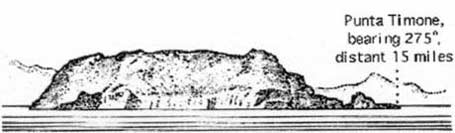
Isola Tavolara, the N extremity of which lies 4.2 miles E of Capo Ceraso, forms the outer SE side of the gulf. It is long, narrow, and almost inaccessible. Punta Cannone, 564m high, stands in the SW part of the island and is the summit. Punta Castellacio, 510m high, stands in the NE part of the island and is prominent. The SE coast, NW coast, and the SW end of the island are steep-to.
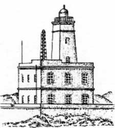
Punta Timone, the NE extremity of the island, is located at the outer end of a small peninsula, 185m high. A light is shown from a tower, 7m high, standing on this point.
Cala del Faro, a cove, lies on the SE side of the peninsula and offers anchorage to small vessels, in depths of 14 to 17m.
 |
|
Isola Tavolara |
Punta del Papa is the E extremity of the island. A disused light structure stands 0.2 mile N of this point. Monte del Papa, 305m high, stands 0.2 mile W of the point and is prominent.
Spalmadore di Terra, a bight, lies at the SW end of Isola Tavolara and offers anchorage, in a depth of 20m, about midway between the entrance points. This berth is exposed to SE winds which send in a heavy sea. Several houses stand at the head of the bight and a conspicuous lime kiln is situated on its E side. A low, narrow, and sandy peninsula extends 0.5 mile SW and forms the NW side of this bight. A shoal area extends up to 0.5 mile NW of this sandy peninsula and Isolotto Verde, Isolotto Spalmatore, and numerous rocks lie on it.
Isolotto Reulino (Isolotto Rosso), 11m high and reddish, lies 0.3 mile S of the S extremity of this sandy peninsula. Isolotto Cana, rocky and grayish, lies 0.7 mile SSE of Isolotto Reulino.
Porto della Taverna indents the coast between Isolotto Reulino and Isolotto Cana. Anchorage can be taken, in a depth of 18m, sand and weed, about 0.5 mile SSW of Isolotto Reulino and in the middle of the entrance to Porto della Taverna. Small vessels, with local knowledge, can anchor, in depths of 9 to 11m, sand, about 0.5 mile farther SSW.
Caution. – Due to the existence of cables, an anchoring and fishing prohibited area lies in Golfo Spurlatta and may best be seen on the chart.
A prohibited area, marked by lighted beacons, surrounds Isola Molarotto and may best be seen on the chart. A nature reserve has been established in the vicinity of Isola Tavolara.
12.21 Isola Molara (40 °52'N, 9°44'E), 158m high, is undulating and partially cultivated. Isola Molarotto, lying 1.7 miles E of the E extremity of Isola Molara, is 51m high, reddish, and conical.
Scogli Cerri (Scogli Tre Fratell), consisting of several above and below-water rocks, lies between 0.5 mile and 1.2 miles SW of Isola Molarotto. The passage between these shoals and Isola Molarotto should not be attempted, but the one between the shoals and Isola Molara can be used.
12.22 Capo Coda Cavallo (40 °50'N, 9°44'E) is reddish and the extremity of a small peninsula, 10m high. A hill of the same name, 103m high, stands 0.7 mile WSW of the cape. Isolotta Proratora, lying close NW of the cape, is also reddish. Punta Sugaraccia, 62m high, is located 0.5 mile W of the cape and is a good landmark.
Cala Coda Cavallo, entered between Punta Sugaraccia and Isolotta Proratora, affords anchorage, in depths of 10 to 14m, sheltered from all winds.
Porto Brandinchi is entered between Isola Rossa (Isola Ruia), located 1.2 miles SW of Capo Coda Cavallo, and Scoglio Testa di Moro, 0.3 mile S. Isola Rossa is a dull reddish color and can be easily identified. The coast between this island and Capo Coda Cavallo is fringed with rocks and should not be approached closer than 0.2 mile. The passage leading between the island and the coast to the N is foul.
Scoglio Testa di Moro, which lies on the outer end of a bank with depths of less than 11m, is triangular in shape and not easily identifiable from a distance, particularly during rough weather. A small promontory, 29m high, stands at the head of Porto Brandinchi and separates two coves which have white sandy beaches. Anchorage is available, in depths of 12 to 14m, less than 0.5 mile W of Isola Rossa. Porto Brandinchi is exposed to SE winds and NE winds cause a heavy surf.
From Porto Brandinchi to Capo Comino, 19 miles SSE, the coast differs greatly in aspect from that farther to the N. Extensive coastal plains, parts of which are marshy, lie between the mountains and the shore, but the coast itself is low, sandy, and noticeably white in places. The land is under cultivation and the farm buildings and scattered villages give it an appearance which contrasts greatly with the destitute and forsaken aspect of most parts of Sardegna.
San Teodoro d’Ovidde, situated 5 miles SSW of Capo Coda Cavallo, can be recognized by its white belfry. From the E, the village is partially hidden by a group of trees. The coast to the N and the point located E of this village should be given a wide berth as they are fringed with dangers.
Punta d’Ottiolo, located 2.5 miles SE of the village, is sharp and rocky. Punta Maggiore, dark and conical, stands 6.5 miles WSW of the point and is 971m high. Isolotto d’Ottiolo, low and inconspicuous, lies 1 mile S of the point and is marked by a light. A submerged reef extends about 0.5 mile E of this islet.
Punta Santa Ana, located 3.5 miles S of Punta d’Ottiolo, can be recognized by a small hill which stands near it. This hill has a long white stripe on its slope, which when seen from the N, has the appearance of a village.
Isolotti dei Pedrami (Scoglio Pedrami), surrounded by several above-water rocks, lies 1.2 miles offshore, 1.7 miles SE of Punta Santa Ana. Punta Pedrami is located 2.4 miles S of Punta Santa Ana and is backed by Monte Lungu, 232m high and cone shaped.
Posada, a village, is situated 2.5 miles SW of Punta Pedrami and stands at the foot of a conspicuous castle which is in ruins at its W end; the houses of the village are gathered on the summit of a cone-shaped hill with steep sides.
12.23 La Caletta (40 °37'N, 9°45'E), the harbor for Siniscola, is easily recognized by Torre San Giovanni, which stands immediately N of it. The harbor, which is used by small craft and coasters, is formed by two breakwaters and is sheltered from all winds. The outer breakwater extends SE from near Torre San Giovanni. There is a berth, 160m long, on the inner side of the outer breakwater. It is used by small vessels up to 4.5m draft.
Punta Santa Lucia, located 2 miles SSE of La Caletta, can be identified by a partly demolished tower. From the N, a group of reddish houses and a long stretch of white sand behind the tower stand out against the background of green vegetation. However, the houses and the stretch of sand are not very conspicuous from the S. A small hill stands 0.3 mile S of the tower and is surmounted by a silo.
12.24 Capo Comino (40 °32'N, 9°50'E), the E extremity of Sardegna, is low, rocky, fringed by reefs, and should be given a wide berth. A light is shown from structure, 20m high, standing on the cape. A disused signal station is situated 0.2 mile WSW of the light.
Isola Ruia (Isola Ruja) lies close inshore on the N side of the cape. It is low, rocky, reddish, and surrounded by rocks. An-chorage, sheltered from SW and NW winds, can be obtained, in a depth of 29m, sand, about 0.7 mile N of this islet. Small vessels, with local knowledge, can obtain shelter from SE winds, closer inshore, in depths of 10m.
Punta Catarina, 1,127m high, stands 14 miles WSW of Capo Comino at the SW end of Monte Alvo de Siniscola, a mountain range. This range shows up white above the dark-colored mountains in front of it and is an excellent landmark. Punta Cupetti, 1,250m high, stands at the NE end of this range.
From Capo Comino to Punta Nera, 8.5 miles SSW, the coast is backed by a series of rocky hills which are mostly covered with vegetation, but show large bare patches of reddish rock in places. Due to dangers fringing this stretch of the coast, vessels should not approach within less than 1 mile.
Punta Ginepro, located 5.8 miles SSW of Capo Comino, is low and fringed with rocks.
Punta Nera (40 °23'N, 9°45'E), located 8.5 miles SSW of Capo Comino, is a low and rounded projection and is darker than the land behind it.
12.25 Golfo di Orosei (40 °14'N, 9°43'E), entered close S of Punta Nera, is bordered by a shorebank which extends 4 miles SW of the N entrance point. This stretch of the coast should not be approached closer than 1 mile due to the alluvial deposits brought down by Fiume Cedrino. The land behind the shorebank is low and marshy, but the rest of the coast of the gulf is mostly high, steep, and inaccessible. A wreck, with a depth of 8m, lies about 1.2 miles offshore, 1.7 miles SSW of Punta Nera.
Orosei, a town, stands 2.5 miles W of Punta Nera. It is situated on the S bank of the Cedrino and is partly visible from seaward. A belfry, with a black cupola, and the facade and dome of a church are prominent. Monte Tuttavista, 805m high, stands 3 miles W of Orosei and is prominent. Anchorage can be taken, in depths of 18 to 30m, fair holding ground, about 1 mile offshore, 1 mile S of Punta Nera.
Cala Gonone, located 7.5 miles SW of Punta Nera, can be easily recognized by a group of houses which stand on the shore and interrupt the uninhabited appearance of this part of the coast. Villa Maria Luisa, light blue with yellow shutters, is the most conspicuous building in this vicinity.
12.26 Capo di Monte Santu (40 °05'N, 9°44'E) is a steep and rugged promontory which rises perpendicularly from the sea. When seen from the N, it appears as a slope with a high terrace. From the E and SE, conspicuous reddish patches show up on its cliffs.
The coast between Capo di Monte Santu and Capo Bellavista is high, rocky, and inaccessible for the first 6 miles, then it becomes low and sandy.
Punta Pedra Longa, located 4 miles SSW of Capo di Monte Santu, is fronted by a detached reddish column which is shaped like a pointed tooth and very conspicuous. From the E, it can be mistaken for the rocky part of Monte Ginnircu from which it projects.
Isola dell’Ogliastra, 47m high, lies 3 miles S of Punta Pedra Longa and is reddish, rocky, and covered with scanty vegetation. Several rocks extend up to 0.2 mile seaward off its NE side. Torre Santa Maria Navarrese stands on a point, 1 mile NW of this islet. The passage leading between the islet and the coast is 0.5 mile wide and has a depth of 8.5m in the fairway.
Anchorage can be taken, in a depth of 15m, sand and weed, about 0.2 mile SSW of Isola dell’Ogliastra or in a depth of 8m, about 200m W of the islet, but these berths are dangerous in SE winds.
Lotzorai, a village, is situated 2 miles W of Isola dell’ Ogliastra and is visible from seaward. A light-colored belfry, with a prominent spire, stands in it.
Gulf di Tortoli is entered between Isola dell’Ogliastra and Capo Bellavista, marked by a light, 2.5 miles S.
Caution. – Winds from the NW and NE quadrants come up suddenly and blow with extreme violence in this vicinity. They may last for 4 or 5 days and are preceded by whitish clouds which cover the peak of Monte Santo.
Winds from the SW quadrant, which also blow with great force, may be forecast by low clouds on the slopes of the mountains around Ogliastro. With these wild winds, the sea rapidly becomes rough and constitutes a danger for vessels in the harbors. In summer, rather weak SE winds prevail and are preceded by a dense mist over all the SE quadrant.
World Port Index No. 39190
12.27 The port of Arbatax lies in the S part of Golfo di Tortoli and on the N side of the promontory of Capo Bellavista. It is the only refuge on the E coast of Sardegna to the S of Olbia.
Depths – Limitations. – The harbor is formed by two breakwaters. The E breakwater extends NW from the N extremity of Capo Bellavista and the W breakwater extends NE from the head of the gulf. The harbor is entered from the NW and has a depth of 12m in its outer part.
The main facilities include West Quay, with 450m of berthing space and depths of 8 to 8.4m alongside; Central Quay, with 100m of berthing and a depth of 5.6m alongside; and South Quay, with 80m of berthing space and a depth of 8.7m alongside. There are facilities for ro-ro vessels and additional berths along the inner side of the E breakwater. Vessels up to 200m in length and 7.6m draft can be accommodated.
Aspect. – The belfry of the cathedral at Tortoli, situated close W of the port, is prominent.
Torre di Arbatax, gray with a red roof, stands at the W side of Arbatax. A conspicuous chimney is situated 0.5 mile W of the tower. Colonia Marina, white with red-roofed buildings, is situated on the beach of the S shore of the harbor.
Pilotage. – Pilotage and berthing services are optional and are available by local people. The port can be contacted on VHF channel 16; the local pilot generally boards about 1 mile NE of the harbor entrance.
Regulations. – Bunkering must be authorized in advance and is carried out only during daylight hours.
Anchorage. – Anchorage is available 0.5 to 0.7 mile N of the light at the head of the E breakwater. The pilot boat leads vessels to anchorage.
12.28 Capo Bellavista (39°56'N, 9°43'E) is a rocky promontory, which due to the low land behind it, appears as a dark-colored island when seen from the N or S. A light is shown from a prominent structure, 19m high, standing on the cape. An auxiliary light is shown from a concrete column.
 |
|
Capo Bellavista Light |
Porto di Frailis, a cove, lies on the S side of the cape and has a depth of 10m in the entrance. Torre San Gemiliano, 42m high, stands on its W entrance point. Anchorage can be taken, sheltered from NW winds, in a depth of 20m, sand, about 0.3 mile SE of the tower.
Between Capo Bellavista and Capo Sferracavallo, 13 miles S, the coast alternates in high rocky stretches and low, sandy, and marshy stretches.
Capo Sferracavallo is overlooked by Punta Cartuceddu, 598m high. Monte Ferru, 875m high, stands 2 miles NW of the cape and is also a good landmark.
Torre San Giovanni di Saralla, 20m high, stands near the coast, 3 miles S of Capo Sferracavallo. A wreck, with a depth of 14m, lies about 0.5 mile S of this tower.
Torre di Murtas stands 7 miles S of Torre San Giovanni di Saralla and several prominent reddish above-water rocks lie close E of it. Cala Murtas, a bight, extends between this tower and Capo San Lorenzo, 3.5 miles S. A white sandy beach lines the shore of the bight. The conspicuous ruins of Castel di Quirra surmount the summit of a conical hill, 296m high, which stands 2.5 miles SW of Torre di Murtas.
Isola di Quirra (Scoglio di Murtas), 12m high and surrounded by smaller rocks, lies 1 mile offshore, 2 miles SSE of Torre di Murtas. From the NNE, this islet appears reddish with a whitish top. A navigable passage leads between the islet and the coast, but it can only be used by vessels with local knowledge.
12.29 Capo San Lorenzo (39°29'N, 9°39'E), 184m high, is dark and rocky. This cape can easily be identified by the dark-colored tower which stands on its summit. A tourist village, consisting of low houses, is situated W of the cape and is visible from the N.
From the cape, the coast, for a distance of 3 miles to the S, is backed close inland by a chain of hills with flattened conical summits. This stretch of the coast is fringed with shoals and should not be approached within 0.5 mile.
Torre Motta (Monte Rosse) stands 2 miles S of the cape and Torre di Porto Corallo, 15m high, stands on a low and rocky point, 1.3 miles farther S.
The coast between Torre di Porto Corallo and Capo Ferrato is low, sandy, and backed by salt water lagoons. It is fringed with shoals and should not be approached within 0.5 mile.
Caution. – It is reported that unexploded ordnance lies within 3 miles of the coast between Torre di Murtas and Torre Monte Rosso.
12.30 Capo Ferrato (39°18'N, 9°38'E), a steep and whitish promontory, rises to Monte Ferru, 299m high. This conical hill stands 1.5 miles inland and is surmounted by a prominent tower. Monte Sette Fratelli, 1,023m high, stands 9 miles W of the cape. Seven rather inconspicuous saw-toothed peaks stands on its flattened summit. A light is shown from a structure, 10m high, standing on the cape.
A rocky shoal, with a least depth of 12.5m, lies about 5 miles SSW of Capo Ferrato.
Between Capo Ferrato and Punta dei Cappuccini, 7 miles S, the coast is mostly low and sandy, but has rocky points in places. Monte Nai and Monte Cannas, two cone-shaped peaks, dominate this stretch of the coast. A prominent road leading to the summit can be seen on the latter mountain.
Monte Turun (Monte Turnu), located 1.5 miles NNW of Punta dei Cappuccini, is a rocky promontory, 56m high. Scoglio di Sant’ Elmo, barely above water and steep-to, lies about 0.2 mile offshore, 0.3 mile E of Monte Turun.
Punta dei Cappuccini rises steeply from the sea and is free from off-lying dangers. Anchorage, during offshore winds, is available, in a depth of 20m, sand, midway between Scoglio di Sant’ Elmo and this point.
Torre di Cala Pira, light-colored and conspicuous, stands 0.7 mile S of Punta dei Cappuccini. Anchorage can be taken, in a depth of 30m, sand, about 0.7 mile SSE of this tower.
Punta Molentis, located 2.5 miles SSW of Torre di Cala Pira, is a small promontory, 7m high. It is fringed with rocks and connected to the mainland by a low sandspit. Anchorage, with local knowledge, can be taken, in a depth of 26m, sand, about midway between Punta Molentis and Isola Serpentara.
12.31 Isola Serpentara (39°08'N, 9°36'E) lies 2.3 miles ENE of Punta Molentis, and Torre di San Luigi surmounts its summit which is 54m high and stands in the N part. This tower is reported to be cylindrical, badly-ruined, and not very prominent. Three rocky islets lie on a shoal bank which extends up to 0.4 mile N of the island. The passage leading between the island and the mainland has a depth of 23m and is free of dangers.
Porto Giunco, a bight, is entered between Punta Molenti and Capo Carbonara, 2.7 miles SSW. Torre Giunco, partly in ruins, stands on the summit of a small promontory, 64m high, 1 mile N of Capo Carbonara. Anchorage can be taken, in a depth of 17m, sand and weed, about 0.7 mile ENE of this tower. However, this berth should not be used during NE or SE winds.
Secca dei Berni, marked by a lighted beacon, lies 1.5 miles SSW of Punta Molentis. This shoal patch has a least depth of 2.4m at its N end.
12.32 Capo Carbonara (39°06'N, 9°31'E), the SE extremity of Sardegna, is the seaward end of a steep peninsula which is covered with low evergreen vegetation and joined to the mainland by a low, sandy isthmus. A light is shown from a structure, 5m high, standing 0.7 mile NNW of the extremity of the cape. A disused signal station, consisting of a house, and Torre Caterina stand on the summit of the peninsula which is 112m high.
 |
|
Isola dei Cavoli from ESE |
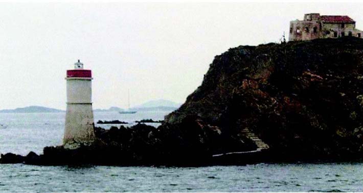
Isola dei Cavoli (39°05'N, 9°32'E), 40m high, lies 0.3 mile SE of Capo Carbonara. It is low, rocky, and partly covered by bushes. A light is shown from a conspicuous structure, 37m high, standing in the NE part of the island.
The island is surrounded by rocks and shoals and should not be closely approached. The passage leading between the island and Capo Carbonara has a least depth of 10.5m in the fairway, but a shoal bank extends up to 0.3 mile NW from the N side of the island. A depth of 15m lies about 1.5 miles S of Isola dei Cavoli Light.
Secca di San Caterina (Secca di Cala Caterina), a rocky patch, lies about 1.5 miles W of Isola dei Cavoli. It has a least depth of 5.1m and is marked by a lighted beacon.
Caution. – Anchoring and fishing are prohibited in the vicinity of a submarine cable which is landed on the NW shore of Isola dei Cavoli.
Golfo di Cagliari
12.33 Golfo di Cagliari (39°10'N, 9°07'E) is entered between Capo Carbonara and Capo di Pula, 25 miles WSW. The two sides of the gulf are mountainous, but a long stretch of sandy shore lies at the head and is broken only by Capo Sant’ Elia. Several extensive saltwater lagoons and areas of marshes lie behind the sandy shore.
The prevailing winds in the gulf are from the W and ENE, and these may increase suddenly to violent storm which can last for 3 days. The W winds gain in velocity as the barometer falls, while the ENE winds increase as the barometer rises.
12.34 East side of Golfo di Cagliari. – Golfo di Carbonara (39°07'N, 9°29'E) is entered between Capo Carbonara and Capo Boi, 4.2 miles WNW. A light is shown at the head of this gulf, 1.5 miles NNW of Capo Carbonara. A prominent white house is situated 0.2 mile NW of this light. A large and conspicuous hotel stands 1.3 miles ENE of Capo Boi. The conspicuous ruins of Fortezza Vecchio are situated on a salient point, 1.5 miles NW of Capo Carbonara. Scoglio Santo Stefano, 18m high and surrounded by rocks, lies about 0.2 mile SW of Fortezza Vecchio.
Capo Boi, the W entrance point of this small gulf, is formed by the termination of a rocky promontory. This promontory is 119m high and its summit is surmounted by Torre di Capo Boi.
Secca de Piscadeddus, with a least depth of 3.7m, lies about 0.5 mile offshore, 1 mile E of the cape.
Monte Maria, 587m high, stands 3 miles NE of Capo Boi and rises gently to a central peak which is easily identified. Anchorage can be taken, in a depth of 20m, sand, about 0.7 mile WNW of Fortezza Vecchio. Smaller vessels can anchor closer inshore, in a depth of 15m.
Quartu Sant’ Elena, a town, is situated 1 mile inland, 13 miles NW of Capo Boi. A white cathedral stands in the town and has a reddish roof, a cupola, and a belfry all of which are prominent.
Capo Sant’ Elia (39°11'N, 9°10'E), located at the head of Golfo di Cagliari, appears as an island when seen from the E. This cape can be easily recognized by its whitish chalk streaks. A light is shown from a prominent tower, with a dwelling, 21m high, standing on the SW side of the cape.
Torre Sant’ Elia is situated on the summit of the cape and Torre del Poetto, partially in ruins, is situated on the E side. Castello Sant’ Ignazio, a small fort, stands 0.5 mile N of the light and The Lazaretto, a large and light-colored building, is situated at the foot of the hill, close W of the fort.
Scoglio Sant Elia, a prominent above-water rock, lies at the extremity of a shoal spit, about 0.2 mile W of the light.
Caution. – Close approach to the coast in the vicinity of Cape Sant’ Elia is prohibited due to the possibility of rock falls.
World Port Index No. 39210
12.35 The port of Cagliari, the largest commercial port of Sardegna, lies at the head of the Golfo di Cagliari, 3 miles NW of Capo Sant’ Elia. The city of Cagliari is the capital of the island.
Port of Cagliari Home Page http://www.porto.cagliari.it
Winds – Weather. – Winds from the NW prevail and generally blow for a considerable length of time. Winds from the SE occur infrequently and winds off the land are more frequent and violent. The winds from the SE raise a sea in the roadstead and a consequent swell results in some parts of the port. A mass of clouds on the mountains is usually an indication of winds from the SE quadrant. The sky with scattered cumuli indicates the probability of winds from the NW.
Tides – Currents. – Tides are negligible, being only 0.3m at springs. However, the water level can be raised by as much as 0.3m by onshore winds.
The currents are weak and mostly influenced by the wind. A current, which sets E, is particularly noticeable with winds from the NW quadrant, and after heavy rains it carries sea weed into the harbor.
Depths – Limitations. – The harbor is protected from the S by Nuovo Molo di Levante, which extends 0.6 mile W and then 0.4 mile SW from the E shore of the promontory. It is also protected from the SW by Nuovo Molo di Ponente, which extends about 1 mile seaward.
The main quays include Calata Sant Agostino, with 278m of total berthing space and a depth of 7.6m alongside; Molo Sabaudo with 652m of total berthing space and depths of 8.1 to 8.5m alongside; Molo Rinascita, with 910m of total berthing space and a depth of 10.9m alongside; and Molo di Levante, with 350m of total berthing space and a depth of 11.1m alongside. There are facilities for container, ro-ro, and bulk vessels.
The harbor also has 817m of total berthing space, with depths of 2.1 to 8.8m alongside for small craft and passenger ferry vessels.
Vessels up to 7.9m draft can be accommodated alongside.
Aspect. – The city is situated on the S slope of a small hill and has a picturesque and imposing appearance. Its buildings, which are arranged in the form of an amphitheater, are dominated by conspicuous towers and cupolas. When the city is approached from the SE, it is hidden by the promontory of Capo Sant’ Elia. The illumination of the city is very conspicuous from seaward and may be visible from up to 20 miles distant.
The following landmarks are conspicuous:
- Torre San Pancrazio, standing in the N and highest part of the city
- Castello San Michele, with four towers and several radio station antennas close above it, standing 1.5 miles NNW of Torre San Pancrazio
- A yellow sanitorium situated at the foot of Monte Urpino, to the E of the city;
- A cathedral, with the dome and steeple in the form of a tower, standing in the city
- Torre dell’ Elefante, reddish with a battlement structure appearing to be composed of two towers, standing in the center of the city
- A convent, which may be recognized by its numerous windows and white cupola, situated in the SE part of the city
- A high -rise building, brown with white horizontal bands, standing in the vicinity of the harbormaster’s office Prominent landmarks in the vicinity of the harbor include a silo and several gantry cranes. A racon is situated at the light structure standing on the head of Nuovo Molo de Levante.
Pilotage. – Pilotage is compulsory for vessels of over 500 grt. Pilots can be contacted on VHF channel 9 or 16 and generally board about 1 mile outside the harbor entrance near the lighted beacon.
Regulations. – A Traffic Separation Scheme is established in the approaches to Cagliari. The scheme consists of two pairs of inbound and outbound lanes separated by a broad separation zone. Each pair of lanes has its own narrow separation zone. The separation zone between the pairs of lanes is marked at its N end by a lighted buoy. The lanes E of the separation zone are for use in approaching the old port. The lanes to the W of the separation zone are designed for use in approaching the new harbor facilities of Nuovo Porto Industriale (Porto Canale). A common precautionary zone lies N of the pairs of lanes between the two harbor entrances.
A Vessel Traffic Service has been established in Cagliari Roads. Three convergence points have been established to permit local authorities to conduct radar tracking and authorize vessel movement in the area, as follows:
- Point P – For vessels bound for the commercial port
- Point Y – For vessels bound for Porto Industriale
- Point Q – For vessels enroute to the Sarroch Oil Terminal
All points are charted. Vessels closing these points must report to the Operations Center or pilots on VHF channel 14 or 16.
Anchorage. – Anchorage can be taken in three separate designated areas, as follows:
- Anchorage Area Bravo – A trapezoidal-shaped area centered 1.7 miles SSW of the light at the head of the Nuovo Molo di Levante. Its NE and SE sides border the outbound lane of the TSS for the new construction harbor. It is adjacent to Anchorage Area Delta.
- Anchorage Area Delta – A quadrilateral-shaped area centered 1.5 miles SW of the same light. Its NE side borders the outbound lane of the TSS for the new industrial port.
- Anchorage Area Foxtrot – Located on the E side of the TSS for the old harbor of Cagliari. It is also a quadrilateral area centered 1.0 mile from the same light. It borders the inbound lane of the TSS for the old port.
- Anchorage Area Golf 1 – Centered 4.5 miles SSE of Nuovo Molo di Levante Lght.
Caution. – The lighted aids are reported to be difficult to distinguish due to the numerous bright neon lights of the city.
Several submarine cables lie in the approaches to the port and may best be seen on the chart.
Ferry traffic in the harbor is heavy.
A Marine Nature Reserve, the limits of which are shown on the chart, has been established on the W side of the gulf between Punta Zavorra (39°03'N, 9°03'E) and Capo Saint Elia. Fishing is restricted within the area. For details, consult local authorities.
Works are in progress (2007) to establish a buoyed fairway in the port approaches. The work area is centered 3.75 miles S of Nuovo Molo di Levante Light and consists of a 2-mile stretch oriented NNW-SSE.
12.36 West side of Golfo di Cagliari. – Villa Marongiu (39°12'N, 9°04'E), a very conspicuous building, is situated 1.7 miles WNW of the head of the outer breakwater at Cagliari and can be recognized by its red color. Torre Su Loi, 9m high, stands 5 miles SSW of the villa and is also conspicuous. Monte Luis, 177m high, stands 2 miles SSW of the tower and is conical with a rounded summit. A prominent chimney stands 2 miles S of the tower.
ENICHEM Pier (Pontile SIL) extends 1 mile SE from a point on the shore, 2.7 miles SW of Villa Marongiu. Vessels up to 6m draft can be handled alongside.
Regulations. – A Traffic Separation Scheme is established in the approaches to the ENICHEM Pier facility. It consists of a NW inbound traffic lane, a southeast bound departure lane, and a narrow separation zone. The entrance is 2.4 miles SE of the head of Pontile ENICHEM Sud.
Caution. – A new harbor, Nuovo Porto Industriale, lying close NE of Villa Marongiu, remains under construction (2000) and is protected by two breakwaters which extend up to 1 mile seaward from the shore in this vicinity. A lighted buoy is moored near the entrance to the new facility.
12.37 Sarroch Oil Terminal (Porto Foxi) (39°05'N, 9°02'E) (World Port Index No. 39215), a refinery with associated flares and tanks, is situated 9 miles SW of Cagliari and stretches for about 1.5 miles along the coast. This installation is served from seaward by Pontile Saras No. 1 and Pontile Saras No. 2.
Depths – Limitations. – Pontile Saras No. 1 extends ENE from the coast, 1.7 miles NNW of Punta Zavorra (39°04'N, 9°03'E). It is illuminated by bright neon lights and is very visible from seaward.
The pierhead extends 0.2 mile SE from the E extremity of the main pier. A turning area, lying NE of this pierhead, and an approach channel are dredged (1980) to a depth of 22.8m and are marked by lighted buoys. A turning area, lying close SW of this pierhead, is dredged (1980) to a depth of 18.8m and is marked by a lighted buoy. An outer approach lighted buoy is moored about 2.6 miles SE of the pierhead.
Tankers up to 380,000 dwt and 20.7m draft can be accommodated at the berth on the NE side of this pierhead.
Two berthing arms extend NW from the N side of Pontile Saras No. 1, and three berthing arms extend SE from the S side. The outer berthing arms on each side of the pier can accommodate tankers up to 270m in length with drafts of 11.6 to 12.8m, but a shoal patch, with a depth of 9.7m, lies close off the head of the NW arm. The inner arm on the NW side and the center arm on the SE side of the pier can accommodate tankers up to 200m in length with drafts of 7.9 to 11m, but a shoal patch, with a depth of 10.2m, lies close W of the head of the SE arm. The inshore berthing arm on the SE side is designed to handle coastal tankers up to 5,000 grt.
Pontile Saras No. 2, also known as Pontile Saras Chimica, extends 0.6 mile E from the shore, 1 mile NNW of Pontile Saras No. 1. An inner berth, suitable for small tankers, extends 230m SE from its midpoint.
A main outer berth, formed by dolphins, is situated at the head. A lighted range, indicated on the chart, assists vessels approaching the pierhead. The outer berth can handle tankers up to 212m in length and 9.2m draft.
Pilotage. – Pilotage is compulsory for vessels over 500 tons. Pilots can be contacted on VHF channel 14 or 16 and board in the vicinity of Anchor Berths G1, G2, G3, or G4, according to the size of the vessel.
Regulations. – A Traffic Separation Scheme is established in the approaches to the terminal. The scheme consists of a NW inbound lane, a SE outbound lane, and a narrow separation zone. The inbound lane is marked on the N by a line of lighted buoys marking the entrance channel. The S limit of the inbound lane is the separation zone and is marked by a line of lighted buoys along the center of the separation zone. The S limit of the outbound lane is the boundary of Anchorage Area Alfa. A lighted safe water buoy, designated Q, marks the entrance to the inbound lane.
Anchorage. – The following designated anchorage berths are situated in the vicinity of the terminal:
- Anchor Berth G1 lies 2.3 miles NE of Punta Zavorra and should be used by vessels with drafts greater than 12.8m.
- Anchor Berth G2 lies 1 mile NNE of Punta Zavorra and should be used by vessels with drafts less than 12.8m.
- Anchor Berth G3 lies 2.5 miles N of Punta Zavorra and should be used by vessels of less than 5,000 tons.
- Anchor Berth G4 lies 2.5 miles E of Punta Zavorra and should be used by large vessels of 250,000 grt.
There are three designated anchorage areas in the vicinity of the terminal, as follows:
- Anchorage Area Alfa – Located E of Punta Zavorra. It contains two anchor berths; Anchor Berth G2 is in the NW part while Anchor Berth G4 is in the E part. Its NE limit borders the outbound TSS lane for the terminal.
- Anchorage Area Charlie – A triangular-shaped area centered 3.4 miles NNE of Punta Zavorra. It contains Anchor Berth G3. Its NE side borders the outbound TSS lane for the ENICHEM Pier.
- Anchorage Area Echo – A quadrilateral area centered 2.3 miles NE of Punta Zavorra. It contains Anchor Berth G1.
Caution. – A restricted area, the limits of which are shown on the chart, lies in the vicinity of the terminal piers. Passage is prohibited in this area except by vessels using the terminal and by craft in the harbor service.
12.38 Punta Zavorra (39°04'N, 9°03'E), located 1.8 miles S of the oil terminal, is dominated by several hills which are covered with vegetation. Sarroch is situated near the top of a small hill, 1.5 miles WNW of the point. A large yellow building stands in the NE part of this village and is very prominent. Torre dei Diavolo stands at the top of a rocky precipice, 1 mile SSW of the point.
Capo di Pula (38°59'N, 9°01'E), the W entrance point of Golfo de Cagliari, is the rocky extremity of a low and sandy peninsula. It is dark-colored and 35m high. A light is shown from a structure, 16m high, standing on the cape.
The peninsula is joined to the mainland by a low isthmus, which is dominated by the church of Sant Efisio. Isolotto Coltellazzo lies close E of the cape and is dark in color.
Isolotto San Macario lies about 0.4 mile offshore, 1.2 miles NNE of the cape. A conspicuous tower stands in its N part and it is steep-to on the E side.
Punta Sa Cresia, 864m high, stands 6 miles NW of the cape. Its gentle sloping sides constitute an excellent landmark in this vicinity.
Golfo di Cagliari to Porto Ponte Romano
12.39 Capo Spartivento (38°53'N, 8°51'E) is located 10 miles SW of Capo di Pula. The coast between consists mostly of very light-colored sandy beaches. Because of underwater rocks, the shore in this vicinity should not be approached closer than 1 mile. Behind the beaches, the land is mostly low but is backed by mountains.
Torre di Cala d’Ostia, 7m high, stands 3.2 miles SW of Capo di Pula and is prominent from seaward. Torre de Chia, 44m high, stands 5 miles farther SW and dominates a small, rocky promontory.
Isolotto Su Giudeu, low and blackish, lies close inshore, 1.2 miles SW of Torre de Chia. On the shore facing this islet can be seen several conspicuous sand dunes. They are very light-colored and from the E, appear as a large white patch.
Capo Spartivento is steep, rocky, and is bordered close inshore by several islets and rocks. Rocky patches lie up to 0.5 mile seaward of the cape and should be avoided. A light is shown from structure, 19m high, standing on the cape. A white house stands close to the light and a disused signal station stands 0.5 mile N of it.
Porto di Malfatano is entered between Isolotti Ferraglione, lying 1 mile WNW of Capo Spartivento, and Capo Malfatano, 1 mile W. The latter cape is the extremity of a steep-sided peninsula, 67m high, which is surmounted by Torre Malfatano. Isola Tuaredda, 31m high with an above-water rock close SW, lies near the head of this inlet. Anchorage can be taken, in a depth of 15m, weed and rock, about 0.2 mile from the shore, in the outer part of the inlet.
12.40 Golfo di Teulada (38°53'N, 8°43'E) is entered between Capo Malfatano and Capo Teulada, 7.5 miles W. Porto di Teulada, a cove, lies at its head. The E shore of the gulf is hilly and barren and should not be closely approached. Torre di Piscinni, 12m high and truncated, dominates a small rocky point, 1.5 miles NW of Capo Malfatano. Porto di Teulada offers shelter during NE and NW winds. Its E shore is fairly steep-to, but a rocky patch, with a depth of 7.5m, lies about 0.3 mile ENE of Punta Niedda, its W entrance point. Torre Budello, 23m high, stands on a point on the W side of Porto di Teulada, near its head. Punta Planedda, 350m high, stands 1.5 miles E of this tower and is surmounted by a conspicuous white building.
Anchorage can be taken, in a depth of 16m, sand and weed, about 0.2 mile SE of Torre Budello. This berth is sheltered from NE and SW winds.
Isolotta Rossa (Isola Rossa), lying 0.5 mile S of Punta Niedda, is 54m high, reddish, and stands out against the coast. From the SE, this islet appears saddle-shaped, but from the SW, only one hillock is visible.
Capo Teulada (38°52'N, 8°39'E), 223m high, rises steeply from the sea at the outer end of a hilly peninsula. This peninsula decreases in height towards the mainland to which it is joined by a low, sandy isthmus.
Cala Brigantina, located 1.5 miles NE of the cape, is open to the SE. It is separated from Porto Scudo, which is also open SE, by a steep promontory, 165m high. Torre di Porto Scudo stands on the SE slope of this promontory.
Caution. – An anchoring and fishing prohibited area lies in the vicinity of Capo Teulada and may best be seen on the chart.
An area of unexploded ordnance lies 1.5 miles WNW of Capo Mulfatano.
12.41 Golfo di Palmas (39°00'N, 8°30'E) is entered between Capo Teulada and Capo Sperone, 11.5 miles NW. It offers good anchorage with the best holding ground being on its E side. Although the gulf is open to the S, the seas raised by winds from that direction are considerably decreased by the time they reach the inner roadstead anchorages. The only off-lying dangers are Secca di Cala Piombo and Secca della Vacca.
On either side of the gulf, the coasts are hilly and extensive salt water lagoons lie near the head.
Cala Piombo, entered close NW of Capo Teulada, is free from dangers and its shores can be approached closely. Its head is bordered by a shorebank and numerous sand dunes. Torre di Cala Piombo stands on the summit of a hill, 193m high, which stands on the N side of this cove.
Secca di Cala Piombo, with a least depth of 1.3m, lies about 0.7 mile WNW of the N entrance point of Cala Piombo. The passage leading between this shoal and the mainland is deep in the fairway.
Punta Menga (38°57'N, 8°35'E), 31m high, is covered with low vegetation and shows up against the whitish dunes behind it. A small house stands on the summit of this point. The shore of Porto Pino, entered SE of the point, is generally sandy with many dunes surrounded by pine bushes.
The coast between Punta Menga and Punta di Porto Botte, 3.5 miles NNW, is rocky and backed by low hills which are covered with vegetation. Porto Botte, entered N of Punta di Porto Botte, has sandy shores backed by low marshes and salt ponds. A pier is situated 0.7 mile E of the N entrance point. It is connected with the railroad system and is a shipping point for charcoal. A warehouse, with a red roof, stands close to a group of white houses in this vicinity. There are also large heaps of charcoal nearby, which are sometimes prominent from seaward. Anchorage, with local knowledge, within this bay is available, in a depth of 10m, sand, SW of the warehouse.
The head of Golfo di Palmas consists of a low and sandy isthmus which connects Isola di Sant’ Antioco to the mainland.
Porto Ponte Romano (39°03'N, 8°28'E)
World Port Index No. 39220
12.42 Porto Ponte Romano (Sant Antioco) is the deep-water harbor for the town of Sant’ Antioco, which is situated on the W side of the head of the gulf.
Winds – Weather. – The prevailing wind in winter is from the NW (Maestrale) and is sometimes rather violent. In other seasons, the winds alternate. Winds from the SE (Sirocco) sometimes brings haze.
Tides – Currents. – Tides are almost negligible, being only 0.3m at springs.
Winds from the NW may lower the water level in the harbor and winds from the SE may raise it. The currents in the approaches are negligible.
Depths – Limitations. – The harbor is approached through a channel, 80m wide. This channel leads E of a detached breakwater and has a depth of 7.5m. The coal pier provides 365m of berthing space on its W side, 320m on its E side, and 222m at its head.; there are depths of 7 to 8m alongside. Banchinna della Sanita extends 150m ENE from the root of the coal pier and has depths up to 8m alongside. Vessels up to 7m draft can be accommodated.
Aspect. – At night, the port is lighted by powerful lights on high columns which are visible for a great distance.
Conspicuous landmarks include the harbormaster’s office building at the base of the pier, a high crane at the coal quay, and a reddish building standing 2 miles NNE of the base of the pier.
The entrance fairway is marked by lighted buoys. A light is shown from a tower, with a dwelling, 22m high, standing at the E side of the harbor.
Pilotage. – Pilotage is compulsory for all vessels of over 500 grt. Pilots can be contacted on VHF channel 12 and generally board about 0.5 mile SE of the outer fairway lighted buoys.
Anchorage. – The entire area of water in the N part of the gulf offers anchorage with a bottom of sand and weed, good holding ground. Vessels should anchor, in a depth of 9m, close SE of the outer end of the entrance channel or, in depths of 14 to 18m, about 3 miles S of the harbor.
Six anchorage areas, S1 to S6, are located in Golfo di Palmas. Coal lightering operations are carried out in S3 (from October 1 through May 31) and in S4 (from June 1 through September 30).
12.43 Punta Cannai (38°58'N, 8°27'E), a low and rocky point, is located 1.6 miles NE of Capo Sperone. It is surmounted by Torre Canai, 29m high, which is gray and very conspicuous from seaward.
The coast for the first 3 miles to the SW of Porto Ponte Romano is low and is bordered by a sandy shore backed by a marshy strip. Along most of the remainder of the W side of the gulf, hills extend to the shore and end mostly in cliffs, 9 to 24m high. Three small coves lie along this stretch of shore and there are short segments of sandy beach at their heads.
Secca della Vacca, with a depth of 4.2m, lies about 1 mile SSW of Punta Cannai and is marked by a beacon.
Capo Sperone (38°57'N, 8°25'E), the S extremity of Isola di Sant’ Antioco, is low and rocky. This cape is dominated by a gray building, with a turret, which stands 0.7 mile N of its seaward extremity. Monte Arbus, 230m high, stands 1 mile ENE of the cape and is the highest of three prominent hills in this vicinity. A beacon is situated on its summit.
Isolotta la Vacca, 95m high, lies 2 miles SE of Capo Sperone and is fringed with numerous above and below-water rocks. Il Vitello, the highest of these above-water rocks, lies close off the N end of the islet.
Isolotta del Toro (38°52'N, 8°25'E), 112m high, lies 5.5 miles S of Capo Sperone. This islet is conical and steep-to. A light is shown from a structure, 6m high, standing on the summit of the islet. A detached shoal, with a least depth of 11.6m, lies about 0.2 mile NW of the islet.
Banco Pomata (Secca Pomata), a detached rocky patch, lies about 2.7 miles WSW of Capo Sperone and has a least depth of 13m. During W gales, the sea breaks heavily over this patch and it should be given a wide berth.
Isola di Sant’ Antioco
12.44 Monte Perdas de Fogu (39°02'N, 8°26'E), 271m high, is the summit of Isola di Sant’ Antioco. Isolotto Mangiabarca, marked by a light, lies close offshore, 8 miles NNW of Capo Sperone. The W coast of the island between the cape and the islet is rocky, indented in places, and is fringed by a shore bank.
The NW coast of the island between Isolotto Mangiabarca and Punta di Manca, 2 miles NNE, is steep and rocky, but not greatly elevated. The conspicuous buildings and chimneys of the tunny fisheries at Spiaggia Grande are situated in the vicinity of Punta Maggiore which is located close NE of the Isolotto Mangiabarca.
Secca della Saline, a shoal area with several rocks awash, lies about 0.2 mile offshore, 1 mile SW of Punta di Manca.
Calasetta (39°06'N, 8°22'E) is situated on the N extremity of Isola di Sant’ Antioco. This town is dominated by a conspicuous tower, 29m high, which stands close W of it. The white cupola of the church, visible only from the N, is also prominent. A pier and a mole front the NE side of the town. The pier has a depth of 4m alongside a spur on its S side. Anchorage can be taken, in depths of 11 to 13m, sand and weed, about 1.2 miles NW of the town.
The N coast of Isola di Sant’ Antioco between Calasetta and Punta Dritta, 2.5 miles E, is low and marshy. Scocca (Scrocca Manu), 148m high, stands midway along this section of the coast and is surmounted by a beacon.
Sant’ Antioco, situated on the NE side of the island, is laid out in the form of an amphitheater on the slope of a hill. An ancient fort dominates the town and the church in also prominent.
Caution. – An anchoring and fishing prohibited area, which may best be seen on the chart, extends between the NW side of Isola di Sant’ Antioco and the SE side of Isola di San Piero.
Isola di San Pietro
12.45 Isola di San Pietro (39°09'N, 8°17'E) is separated from Isola di Sant’ Antioco and the mainland coast of Sardegna by Canale di San Pietro. The N and central portions of the island are rugged and hilly, but the S part is rather flat and more extensively cultivated. Guardia dei Mori, 215m high, is the summit of the island. It stands in the N part and is surmounted by a prominent building.
The S coast of the island is fringed with reefs. Punta delle Colonne, the SE extremity, takes its name from a group of conspicuous columnar rocks standing on a rocky area which extends up to 0.2 mile S of the point.
12.46 Capo Sandalo (39°09'N, 8°13'E), the W extremity of the island, is rugged and fronted by a small islet. A light is shown from a prominent structure, 30m high, standing on the cape. A radiobeacon is situated at the light.
Isolotto del Corno (Isolotto del Gallo), 16m high, lies 0.8 mile W of the cape and is steep-to.
La Punta, the NE extremity of Isola di San Pietro, is the extremity of a level promontory, 20m high. Several buildings and a tall chimney stand at a tunny fishery on this promontory.
Isola Piana, 19m high, lies 0.5 mile NE of La Punta. A light is shown from a structure, 8m high, standing on the N side of the island. This island is rocky, covered with vegetation, and the buildings and a tall chimney of a tunny fishery are situated on its E side. Isolotto dei Ratti, 6m high, lies close S of Isola Piana and is covered with vegetation.
The E coast of Isola di San Pietro is low, sandy, and fringed with numerous shoals. An extensive flat extends E from this coast and connects it with the coast of Sardegna.
Caution. – Tunny nets, which are generally marked, may extend as much as 3 miles N of Isola di San Pietro.
Punta Grossa is located 1.2 miles S of La Punta. A group of warehouses, no longer in use, are situated close N of the point and are conspicuous from seaward.
12.47 Carloforte (39°08'N, 8°19'E) (World Port Index No. 39250), a small harbor, lies on the E side of Isola di San Pietra and fronts the only town on the island. It is sheltered by two breakwaters and mostly used by ferries and fishing boats.
All winds cause surf in the harbor, especially winds from the N and SE. Winds from the NE and SE quadrants also cause heavy seas in the harbor.
There is a depth of 5.4m alongside the main quay. Vessels up to 3,000 dwt and 4.6m draft can be accommodated.
Several shoals lie in the approach and two narrow channels lead to the harbor entrance. Both are marked by lighted buoys and indicated by range beacons, some lighted, which may best be seen on the chart.
Prominent landmarks in this vicinity include Torre San Vittorio, standing close SE of the town; the steeple of the cathedral in the town; and a large reddish building standing close NW of the town.
Pilotage is not compulsory for the port, but must be used for passage through Canale di San Pietro. Pilots for the canal are provided by Porto di Sant Antioco. The port can be contacted on VHF channel 11 or 16.
Vessels must contact the port authorities on VHF channel 16 prior to entering or leaving the port. Departing vessels have the right-of-way over vessels entering the port. There is a speed limit of 3 knots in the harbor.
Vessels with drafts up to 4m may obtain anchorage about 0.8 mile E of the cathedral belfry. This berth is on the S range line.
Caution. – An outfall pipeline extends 1 mile E from a point on the coast, close N of Carloforte.
A submarine cable, which may best be seen on the chart, extends WNW from a point on the coast, close N of Carloforte. A least depth of 4.7m lies between the breakwater heads. A fishing prohibited area, best seen on the chart, is centered on the anchorage in position 39°10.6'N, 8°20.0'E
12.48 Numerous shoal areas obstruct Canale di San Pietro and restrict passage to vessels with drafts of less than 4.6m. The S part of the passage is deep and clear. The safest route through the center portion of the passage is in the vicinity of several buoys which are moored about 1 mile off Carloforte. Passage just E of these buoys leads over a bank in a least depth of 5m. Caution and careful navigation are necessary in this area. The N part of the passage has several offshore banks with wide areas of open water between them and the shores.
Anchorage in the S part of Canale di San Pietro is preferable to that in the N part, because of its less difficult approach. It is exposed to SW winds, but these are neither frequent nor violent. Anchorage, sheltered from NW winds, can be taken, in depths 11 to 13m, sand and weed, about 1.5 miles SE of Torre San Vittorio.
Anchorage can be taken, in a depth of 12m, sand and weed, in the N part of Canale di San Pietro, about 1 mile SE of Isola Piana.
Pilotage is compulsory for vessels transiting the Canale di San Pietro and those heading to or coming from Porto Vesme.
World Port Index No. 39260
12.49 The port of Porto Vesme lies 4.5 miles NE of Carloforte and is mostly used for the shipping of bulk minerals and coal.
Winds – Weather. – The predominant winds are from the NW, SSE, and SSW. During the winter, NW winds may produce a strong undertow in the port.
Tides – Currents. – The tidal range is generally about 0.3m, although from December to April it may be as much as 0.6m.
In general, the tidal currents are negligible, but may become appreciable during strong winds.
Depths – Limitations. – The harbor, which is protected by breakwaters, is approached through a channel, 200m wide. The fairway of this channel is dredged to a depth of 14m. The entrance between the breakwater heads is 134m wide.
The main facilities include Banchina Commerciale, an ore quay, which has 280m of berthing space, with a depth of 8.2m alongside, and whose W side is reserved for vessels up to 32,500 dwt with a maximum length of 200m; Pontile Euroallumina, a bulk ore terminal, which has 400m of berthing space with a depth of 13m alongside; and Pontile Samin, 40m long, with a depth of 8.5m alongside. This berth is used for sulfuric acid and can handle vessels with a maximum length of 100m and a maximum draft of 9m.
It is reported that vessels up to 92,000 dwt and 12m draft can be accommodated in the harbor.
Aspect. – Scoglio La Ghingetta, lying 1 mile NW of the harbor entrance, is surrounded by rocks. A light is shown from a tower, 10m high, standing on this rocky shoal.
Several shoal patches, with depths of 3 to 7m, lie about 1.6 miles WNW of the light and are marked by a lighted buoy.
Portoscuso, a small craft harbor, lies close NW of Porto Vesme and is protected by breakwaters. Torre Portoscuso, a large structure, stands close W of a village, 0.2 mile NW of the harbor.
The coal conveyor loading system and two chimneys of an electric plant, which are situated at Porto Vesme, are conspicuous from seaward. The entrance channel is marked by lighted buoys.
Pilotage. – Pilotage is compulsory for vessels over 500 grt. Vessels approaching from the N usually embark the pilot about 2 miles N of Isola Piana. Vessels approaching from the S and all vessels with a draft of less than 5.2m embark the pilot about 1 mile N of Calasetta. In inclement weather from the NW, vessels arriving from the N will be directed to head to the entrance of South Channel or to the Gulf of Palmas to board the pilot. The pilots and harbor can be contacted on VHF channel 12. Pilots are provided from Porto di Sant’ Antioco.
Anchorage. – Anchorage for vessels with drafts not exceeding 6m is available about 0.4 mile E of Scoglio La Ghinghetta. Anchorage, sheltered from all but NW winds, can be obtained in Anchorage Papa, in a depth of 13m, sand and weed, good holding ground, about 1.2 miles SW of Porto Vesme.
Other anchorage berths have been established in the approaches to Porto Vesme. Zone P1, Zone P2, and Zone P5 each have a radius of 0.3 mile and are for vessels with a maximum draft of 8m. Zone P3 and Zone P4 each have a radius of 0.2 mile and are for vessels with a maximum draft of 5.2m.
Directions. – From the NW, large vessels are advised to approach the port by passing between Isola dei Meli and Secca Martin in depths of about 30m. Smaller vessels may pass between Isola Piana and Secca Grande in depths of about 15m, but currents setting NNE towards Secca Grande are sometimes experienced.
Caution. – Entry into port is not recommended with strong SE winds, which increase the current setting on the breakwater and make maneuvering difficult in the very restricted waters.
A prohibited entrance area, with a radius of 300m, surrounds Scoglio La Ghinghetta. The entrance fairway is subject to silting.
Canale di San Pietro to Porto di Oristano
12.50 Capo Altano (39°14'N, 8°22'E), located 2.5 miles NW of Porte Vesme, is high and rocky. Isola dei Meli, 11m high, lies 0.5 mile W of the cape and is surrounded by rocks and foul ground.
Caution. – Tunny nets, which are generally marked, may extend as much as 3 miles W of Capo Altano.
12.51 From Capo Altano to Porto Paglia, 3.5 miles NW, the coast is high and rocky. At Porto Paglia, a small inlet, the buildings of a tunny-processing plant are conspicuous. A low reddish tower stands close W of the buildings and is prominent from seaward.
Fontana a Mare, situated 1.5 miles NNE of Porto Paglia, can be recognized by a conspicuous white chimney dominating a group of ruined houses. A white pipeline descends down the side of a hill from the chimney. A stretch of sandy beach extends between Porto Paglia and Fontana a Mare. At Porto Nebida, situated 1 mile N of Fontana a Mare, a four-story building stands at the base of a small wharf and is prominent from seaward.
Scoglio Pan di Zucchero (39°20'N, 8°24'E), 132m high, lies close offshore. When seen from the SW, this rock blends in with the coastal background and is not easy to identify.
Porto Flavia, a small inlet with steep shores, lies close NE of Scoglio Pan di Zucchero. An ore-loading machine, situated in an opening in the cliff, loads ore directly into holds of vessels via a chute. Vessels usually anchor, in a depth of 9m, close to the loading facility and moor to bollards on the shore. In addition, there are several mooring buoys in the vicinity. The berth is sheltered from N winds, but loading operations may be effected during the prevailing NW winds.
Torre di Cala Domestica, 40m high, stands 2.5 miles NNW of Porto Flavia and is prominent.
12.52 Capo Pecora (39°27'N, 8°23'E), 18m high, is a small projection which is joined to the coast by a low stretch of land. It is dominated by Punta del Guardianu, 478m high, which stands 1.2 miles inland. An above-water rock lies close off the W extremity of this cape. The conspicuous peak of Monte Arcuentu, 785m high, stands 12 miles NE of the cape.
The coast between Capo Pecora and Capo della Frasca (Capo Frasca), 19 miles NNE, is steep and rugged. At the center of this stretch, a large isolated building stands at Porto Tremolia.
Porto Palma, a small inlet, is entered 3 miles N of Porto Tremolia and has a sandy beach at its head. Several buildings and a tall chimney of a tunny-fisheries plant are situated along this beach.
Torre di Flumentorgiu, 61m high, stands on a small point, 1 mile NNW of Porto Palma. It is conspicuous and very visible from seaward.
Capo Frasca (39°46'N, 8°27'E) is the N extremity of Piana di Santadi, a plateau, which rises perpendicularly from the sea and is covered with vegetation. A light is shown from a structure, 8m high, standing on the cape.
Caution. – An anchoring and fishing prohibited area, the limits of which are shown on the chart, lies in the vicinity of Capo Frasca.
12.53 Golfo di Oristano (39°49'N, 8°30'E) is entered between Capo della Frasca and Capo di San Marco, 5.5 miles NNW. The gulf has low, sandy, and gently sloping shores. In places, there are several whitish sand dunes, with patches of vegetation, backed by extensive lagoons and marshes.
Conspicuous landmarks in the approach to this gulf include Monte Sa Trebinalada, 795m high, with two peaks, standing miles E of Capo Frasca; Monte Urtigu, 1,050m high, with gently sloping sides, standing 19 miles NNE of Capo San Marco; and Torre San Giovanni, 50m high and surmounted by two small turrets standing on a hill, 1 mile N of Capo di San Marco.
A prominent bell tower stands in the town of Oristano, which is situated 7.5 miles ENE of Capo di San Marco.
Torre Grande (Gran Torre), standing 4.7 miles NE of Capo di San Marco, is a large tower, 15m high, surrounded by houses. A light is shown from this tower.
Pontile Merci, situated 0.9 mile SE of Torre Grande, projects 180m SW from the shore. Its head is rectangular and has a depth of 6.9m alongside.
Pontile Perlite, situated close SE of Pontile Merci, projects 135m WSW from the shore. It has a T-head, 37m long, with a depth of 6.7m alongside.
Pontile SIPSA, situated close SE of Pontile Perlite, projects 180m WSW from the shore. The head is fitted with pipelines for crude oil and has depths of 7 to 8m alongside.
Porto di Oristano (39°52'N, 8°33'E)
World Port Index No. 39261
12.54 Porto di Oristano lies 3 miles SE of Torre Grande and is entered through a dredged channel leading SE from a deep area which extends NE into Golfo di Oristano.
Depths – Limitations. – The harbor entrance is protected by a mole and approached by a channel, 200m wide, which has a dredged depth of 13m (1982).
The harbor consists of an outer basin and an inner basin, both of which have a depth of 12m. The main quays include Banchina Sottoflutto, with 306m of berthing space and a depth of 10.5m alongside; Molo Sottoflutto, with 120m of berthing space and a depth of 9.5m alongside; Banchina Est, with 407m of berthing space and a depth of 10.5m alongside; Banchina Nord, with 500m of berthing space and a depth of 11m alongside; and Banchina Martini, with 250m of berthing space and a depth of 11m alongside.
Vessels up to 60,000 dwt, 300m in length, and 11.7m draft can be accommodated.
Aspect. – An outer lighted buoy is moored about 1.2 miles SSW of Torre Grande and marks the approach. A lighted range indicates the entrance channel.
Pilotage. – Pilotage is compulsory. Pilots can be contacted on VHF channel 12 and board 2 miles NW of the port. Tugs are available from Porto Torres, but 48 hours advance notice must be given.
Anchorage. – Small vessels can obtain anchorage, in a depth of 6m, about 0.6 mile offshore, SSW of Torre Grande. Two designated anchor berths are available, with limits as shown on the chart. Berth C is located 1 mile SE of Capo di San Marco. Berth D is NE of Berth C and centered 2.2 miles E of Capo di San Marco.
Caution. – Depths within Porto di Oristano are subject to change. Mariners are advised to contact the port authority for the latest information.
Porto di Oristano to Isola Asinara
12.55 Capo di San Marco (39°52'N, 8°26'E), 56m high, is formed by a small and rocky promontory which is joined to the mainland by a low and narrow strip of land. A light is shown from a prominent structure, 15m high, standing on the cape.
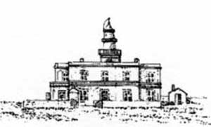 |
|
Capo di San Marco Light bearing N |
Torre Vecchia, a low tower, is situated 0.5 mile NE of the light.
Caution. – Unexploded ordnance is reported (1994) to lie close SE of Capo di San Marco.
A prohibited area, best seen on the chart, encircles Capo di San Marco.
Lighted superbuoys, best seen on the chart, lie up to 40 miles W and SW of Capo di San Marco. These buoys are anchored to the bottom by nylon cables and are a hazard to navigation and to fishing.
12.56 Capo Mannu (40 °02'N, 8°23'E) is located 11 miles NNW of Capo di San Marco. The coast between is backed by a range of low hills covered with scrub in its S part and is low and marshy in its N part. Torre Sevo, standing 2.8 miles NW of Capo di San Marco, is very visible from seaward.
Il Catalano, a dark-colored rock, lies on a shoal area, about 7.5 miles W of Capo di San Marco. It is 11m high and is surmounted by a disused light structure. A detached rocky patch, with a depth of 12m, lies about 1.2 miles SSW of this rock and a dangerous wreck lies in this vicinity.
Rocky shoals, with depths 2.5m and 8m, lie about 0.7 mile NNE and 2.5 miles NNE, respectively, of Il Catalano.
Isolotto Mal di Ventre (39°59'N, 8°18'E), 18m high, is flat, rocky, and fringed by shoals. Rocky shoals extend up to 1 mile NE of the island and a detached rocky area, awash, lies about 1 mile SW of the island. A light is shown from a structure, 4m high, standing on the summit of the island. Anchorage is available, in a depth of 16m, about 0.5 mile SE of the island and sheltered from NW winds.
Caution. – A prohibited area, best seen on the chart, extends from the NE extremity to the SW extremity enclosing the entire W part of the island.
12.57 Capo Mannu, 48m high and precipitous, is joined to the mainland by a marshy isthmus. When seen from the N or S, this cape appears to consist of two flat islets. A light is shown from a structure, 11m high, standing on the cape. Torre Mora and Torre Mannu stand close S and 0.7 mile NE, respectively, of the light.
Cala Saline, entered S of Capo Mannu, offers shelter to vessels from winds from the NE and SE. Local knowledge is essential.
Isola de sa Tounaria (Isolotto Peloso), 12m high, lies close offshore, 1.7 miles NE of Capo Mannu.
The coast between Capo Mannu and Capo Marargiu, 18 miles N, is rugged and somewhat high. Monte Urtigu dominates the first section of this stretch of the coast.
Torre Foghe, a conspicuous tower, stands near the mouth of the Fiume Mannu, 9.2 miles NE of Capo Mannu. The town and cathedral of Cuglieri are situated 4.5 miles E of this tower and are plainly visible from seaward.
Rocks extend up to 0.5 mile offshore, 2 miles N of Torre Foghe.
Torre Columbargia, 33m high, stands on a reddish hill, 1.2 miles N of Torre Foghe. The town of Tresnuraghes is situated 3 miles ENE of this tower and can easily be recognized by its cathedral dome which is fronted by two spires.
Isola Rossa (40 °17'N, 8°28'E), 15m high, lies close off the S entrance point of Fiume Temi to which it is joined by a dike. A large and conspicuous tower stands on the summit of the island.
A small breakwater extends SSE from the S extremity of this island and a pier, with a depth of 4m at its head, extends from the E side of the island. Anchorage can be taken, in a depth of 16m, about 0.2 mile NW of the island, but the berth is exposed.
12.58 Bosa Marina (40 °16'N, 8°32'E) is situated close NE of Isola Rossa and on the S bank of Fiume Temo. Several conspicuous resort buildings stand 1 mile S of the town. A quay, 115m long, fronts the town and has a depth of 3m alongside. There is an extensive marina and small craft harbor in this vicinity.
Torre Argentiera stands 2.5 miles N of Isola Rossa and is visible from seaward. However, a conspicuous steep-sided hill, scored with vertical furrows, stands close E of the tower and is a better landmark.
Capo Marargiu (40 °20'N, 8°23'E) is high, bordered by rocks, and distinctive due to its greenish color. A shoal patch, with a depth of 5m, lies about 0.5 mile SW of the cape.
Torre Badde Iana stands 6.5 miles N of the cape and is white and prominent.
Punta Poglina, located 4 miles NNW of Torre Badde Iana, is low and surmounted by Torre Poglina, partially in ruins.
Rada d’Alghero (40 °34'N, 8°15'E) is entered between the town of Alghero, situated 13 miles N of Capo Marargiu, and Capo Galera, 3 miles WNW. The E shore of this bay is low and sandy, and the W shore is hilly and rocky. An undulating coastal plain, partly under cultivation, lies immediately inland of the head of this bay.
Isolotto della Maddalena, marked by a light, lies on the shore bank, 0.9 mile NW of Alghero. It is 4m high and rocky. Because of its reddish color, this islet shows up against the light sandy background of the shore. Depths of less than 5.5m extend SW from this islet.
Conspicuous landmarks in this vicinity include Monte Doglia, 437m high and conical, standing 3.5 miles N of Capo Galera; a yellow villa standing on Capo Galera; Torre Lazzaretto, standing 0.5 mile N of Capo Galera; and a belfry standing 1.2 miles N of Alghero.
This bay is open to winds from the SW which may last as long as 8 days. When the summit of Monte Doglia is enveloped in dense clouds, winds from the S or SW can be expected. A dense fog over the coast to the S of Alghero is a sign of winds from the W or NW.
Anchorage is available, in a depth of 20m, sand and weed, good holding ground, about 0.7 mile W of Isolotto della Maddalena. Anchorage is also available, in a depth of 14m, sand and weed, about 0.2 mile E of Torre Lazzaretto.
Alghero (40 °34'N, 8°19'E) (World Port Index No. 39280), a small harbor, is sheltered by two breakwaters. The town stands on a small rocky promontory and is surrounded by medieval walls. The harbor is accessible to small vessels up to 70m in length and 4m draft. Pilotage is not compulsory, but is available. The pilot may be contacted on VHF channel 11 or 16.
Fertilia, a small town, is situated 2.5 miles NE of Capo Galera. It has a prominent church spire and is fronted by a small and shallow harbor.
12.59 Punta del Giglio (40 °34'N, 8°12'E) is located 2 miles W of Capo Galera and the coast between is high and rocky. Punta del Giglio rises to a height of 108m, 0.2 mile inland, and is surmounted by a tower. Punta del Rumani, 169m high, stands near the coast, about midway along this stretch.
Porto Conte, entered close W of Punta del Giglio, offers shelter from all winds. Monte Timidone, 361m high, stands on the W side of this inlet and dominates the whole of this area. With strong N winds, it is advisable to keep close to the NW shore of this inlet and in the lee of Monte Timidone. When this hill is obscured by clouds, strong NW winds can be expected and may last for up to 5 days.
Torre Nuova stands on a point located 1.5 miles N of Punta del Giglio. This point is marked by a light and several hotels and other prominent buildings are situated in its vicinity. Anchorage can be taken, in depths of 6 to 20m, good holding ground, within this inlet.
12.60 Capo Caccia (40 °34'N, 8°10'E), the W entrance point of Porto Conte, is an imposing dark-colored promontory with an almost perpendicular rock face. A light is shown from a structure, 24m high, standing on the cape.
Caution. – A prohibited anchorage area extends up to 0.3 mile seaward around Capo Caccia.
The coast from Capo Caccia to Punta delle Gessiere, 4 miles N, is high and inaccessible. Isolotto Foradada, 182m high and pierced by a hole, lies 0.7 mile NW of the cape and is conspicuous. Isola Piana lies 2.7 miles NNW of the cape. It is 107m high and conspicuous. Torre Pegna stands on the brink of a cliff, 0.7 mile SSE of the islet.
Torre di Bantine Sale, 20m high and partly demolished, stands on the S entrance point of Porto Ferro, 4.2 miles NE of Punta delle Gessiere. Torre Bianca, 64m high and conspicuous, dominates a small conical promontory covered with brush on the N entrance point of this bay.
Capo dell’ Argentiera (40 °44'N, 8°08'E), 221m high, can be easily recognized. Miniera dell’ Argentiera stands close E of the cape. A prominent church and the conspicuous equipment of the continually active mines are situated in this village.
From Capo dell’ Argentiera to Capo del Falcone, 14 miles N, the coast is high, rocky, and inaccessible. It has a whitish color for about 3 miles to the SSW of Capo del Falcone.
Capo Mannu, located 4 miles NNE of Capo dell’ Argentiera, is formed by a dark spur-shaped promontory. Isola dei Porti, lying 6 miles NNE of Capo Mannu, appears conical from the SW, but from the NW it is difficult to distinguish from the coast.
Punta Scoglietti, located 2.5 miles SSW of Capo del Falcone, is low and rocky. When seen from the S, this point appears to be whitish. It should not be approached closer than 0.5 mile because of the fringing rocks and shoals.
12.61 Capo del Falcone (40 °58'N, 8°12'E) is formed by the N termination of a small peninsula. The summit of this peninsula, 189m high, stands 1 mile S of its seaward extremity and is surmounted by Torre del Falcone, a conspicuous tower.
Isola Piana, 23m high, lies close NE of the cape and divides the canal leading between Sardegna and Isola Asinara into two passages. A conspicuous dark tower stands on the NE side of this islet. Passagio della Pelosa, the S passage, is available only to small craft with local knowledge. Passagio dei Fornelli, the N passage, has a depth of 3m in the fairway and is available only to small vessels with local knowledge during good weather. An overhead cable, with a height of 25m, spans the W entrance of Passagio dei Fornelli and is supported by three pylons.
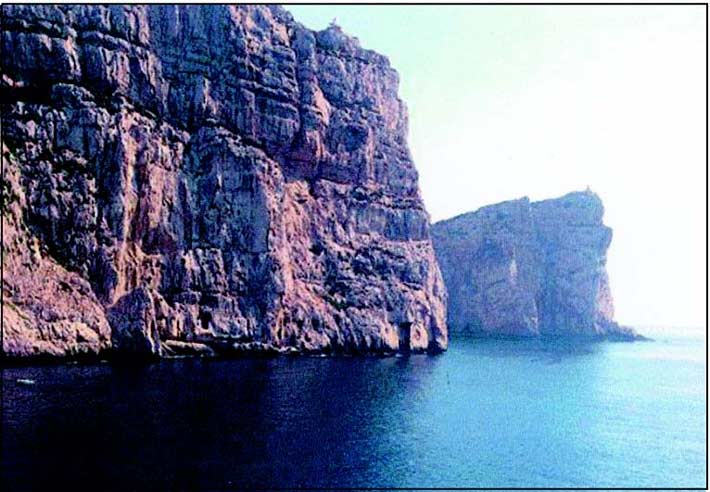 |
|
Capo Caccia |
Isola Asinara
12.62 Isola Asinara (41°04'N, 8°16'E) consists of four principal parts, all high, which are connected by low isthmuses. The principal elevations of the island, from S to N, are Monte Maestra Fornelli, 265m high ; Monte Tumbarino, 241m high ; Monte Ruda, 215m high ; and Monte Scomunica, 408m high.
Punta della Scorno (Punta Caprara) (41°07'N, 8°19'E), the N extremity of the island, is fringed with shoals which extend up to 0.2 mile N of it. A light is shown from a prominent structure, 35m high, standing on the point.
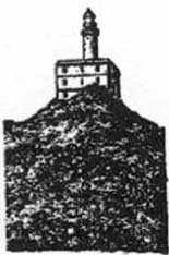 |
|
Punta della Scorno (Punta Caprara) Light |
The W coast of the island is inaccessible and barren. The E coast is partly rocky, partly sandy, and fringed with rocks, except along the NE part which is generally steep-to. The buildings of a penal colony are situated on the N side of Cala d’Oliva, which is entered 2.5 miles SSE of Punta Caprara.
Punta Trabuccato is located 4.3 miles SSE of Punta della Scorno. This point is the extremity of a small peninsula which is connected to Isola Asinara by a low isthmus. Torre Trabuccato stands on the summit of this low peninsula.
Rada della Reale, entered SW of Punta Trabuccato, has high and rugged shores. Three groups of buildings of a quarantine station stand on the N shore of this inlet. Two masonry piers are situated near the W group of these buildings. The larger one, 75m long and T-shaped, has a depth of 5m close off its head.
Scogli Neri, a group of drying rocks, extends up to 1.3 miles SE from the vicinity of the quarantine station and is marked by a lighted beacon. Anchorage is available on either side of this group, in a depth of 10m, sand and weed. Regulations state that these anchorages be used only in emergencies. Winds from the E and NE cause a heavy swell in this bight.
Caution. – The island and waters surrounding the coastline are known as Asinara National Park.
A restricted area, the limits of which are shown on the chart, lies in the vicinity of Isola Asinara. Landing is prohibited, except for persons engaged in rescue or surveillance activities or those with specific permission from park authorities.
12.63 Golfo dell’ Asinara (41°00'N, 8°30'E), entered E of Isola Asinara, offers good anchorage, sheltered from winds from the NW, SW, and SE quadrants.
Between Punta Negra, located 1.8 miles SE of Capo del Falcone, and Porto Torres, 9 miles SE, the shores of Golfo dell’ Asinara are low, sandy, and backed by ponds. From Porto Torres to Punta Tramontana, 11.3 miles ENE, the shore consists of a series of sand dunes with a scattering of vegetation. The remainder of the coast is composed of alternate high rocky tracts and low sandy sections. In the background, the undulating terrain rises gradually towards the higher elevations of the interior of Sardegna.
Winds from the NW, frequently very stormy, prevail in this gulf. Winds from the NE, which are infrequent, usually raise a rough sea in the gulf. If the coast of Sardegna is plainly visible from the offing, generally NE or SE winds are to be expected. When Monte Scomunica, standing near the N end of Isola Asinara, is covered with clouds, generally strong NW or SW winds are to be expected. There are no well-defined currents in the gulf and those which have been encountered are mainly surface currents influenced by the wind.
Stintino (39°56'N, 8°14'E), a small town, is situated 1 mile S of Punta Negra and has several prominent white houses. Two conspicuous chimneys of a tunny fisheries plant stand 1 mile S of the town. Also prominent at this side of the gulf are Monte Elva, 112m high, and Monte Alvaro, 342m high, which stand 4.5 miles W and 4.5 miles SW, respectively of Porto Torres. Anchorage can be taken, in a depth of 29m, sand, good holding ground, about 0.7 mile E of Stintino.
Porto Torres (40 °50'N, 8°24'E)
World Port Index No. 39310
12.64 Porto Torres lies at the head of Golfo dell’ Asinara and consists of a new harbor and an old harbor.
Winds – Weather. – A violent NW wind, which is common through the winter season, may create a heavy sea and considerable surf in the approaches to the port.
Tides – Currents. – The tide is negligible, rising only 0.3m at springs.
Depths – Limitations. – The old harbor, lying at the E side of the port, is protected by two breakwaters which form an entrance, 270m wide, facing NE. This harbor is divided into two basins. Avamporto is the outer basin and Porto Interno is the inner basin.
A part of the E side of the W breakwater is used for berthing tankers with drafts up to 8.2m.
A quay, 450m long, is situated on the SW side of the E breakwater and has depths of 8.2 to 9.1m alongside its outer end, and depths of 6.1 to 8.5m alongside its inner end.
The entrance to the inner basin leads between two moles and is 80m wide. This basin has 740m of quayage, with depths of 5.5 to 6.5m alongside. Vessels up to 150m in length and 8m draft can be accommodated in the old harbor.
The new harbor, which includes an oil terminal, lies at the W side of the port and is protected by a breakwater which extends about 0.6 mile NNE, 0.5 mile ENE, and then 1 mile E. It has facilities for container, ro-ro, bulk, and tanker vessels.
Pontile di Levante, at the E side of the new harbor, extends 0.5 mile N from the shore. It has two berths for tankers at the outer end, with depths of 12.7 to 14.5m alongside, and two berths for dry cargo vessels at the inner end with depths of 12m alongside.
Pontile ANIC No. 1 extends 0.6 mile N from the shore, 0.3 mile W of Pontile di Levante. It has three berths with depths of 9 to 16m alongside. Berthing is done during daylight hours only; unberthing is allowed up to 2359 local time.
Pontile ANIC No. 2 extends 0.5 mile N from the shore, 0.7 mile W of Pontile ANIC No. 1. There are three berths, with depths alongside of 4 to 9m.
Aspect. – The town is situated on rather flat terrain and is without any conspicuous heights when seen from seaward. The most conspicuous landmark is the chimney of the cement works which stands 0.8 mile WSW of the root of the W breakwater. This chimney is reported to be clearly visible because of its outline against the sky. Also prominent from seaward are the Colonia Marina, a pink building, standing 0.5 mile E of the town; several green tanks situated to the W of the town; and the two loading gantries at the harbor.
Vessels of unlimited size with drafts up to 14.5m can be accommodated.
A light is shown from a prominent structure, 20m high, standing 0.2 mile S of the old harbor. A light with racon is situated at the head of the W breakwater at the old harbor.
Pilotage. – Pilotage is compulsory for vessels over 500 tons. Pilots can be contacted on VHF channel 12 or 16 and generally board about 1 mile from the breakwater. Large tankers are boarded up to 3 miles from the breakwater.
Caution. – A submarine power cable lies in the entrance to the old harbor and may best be seen on the chart.
The navigation lights at the harbor are reported to be sometimes difficult to distinguish against the bright lights of the industrial area.
Several submarine cables, which may best be seen on the chart, extend N from the shore of the gulf, close E of the port.
12.65 Punta Tramontana (40 °53'N, 8°38'E), the E entrance point of Golfo dell’ Asinara, can be easily recognized by a conspicuous tank standing on it. The coast between this point and Porto Torres is moderately high and steep, with a succession of sand dunes in the E part.
Castelsardo, a town, stands on a small conical promontory, 4 miles NE of Punta Tramontana. An ancient fortified citadel, surmounted by the tall antenna of a television relay station, stands on the summit of the promontory which is 114m high. From the W, the belfry of the cathedral can be seen at a lower level and appears similar to a lighthouse. Torre Fragiano, partly ruined, stands close W of the town.
Secca di Castelsardo, a detached rocky patch with a depth of 11m, lies about 5.5 miles N of Castelsardo. The sea breaks on this patch during strong N winds. Secca di Punta Spinosa, with a depth of 9m, lies about 1 mile W of Castelsardo.
San Pietro a Mare is situated SW of the mouth of Fiume Coghinas, 4 miles E of Castelsardo. This village stands behind sand dunes and a conspicuous chimney can be seen close S of it.
Fiume Coghinas is the second largest river in Sardegna, but its mouth cannot be easily identified from seaward. The sea in the vicinity of the mouth of this river becomes turbid only when the river is swollen.
Isola Rossa, lying 9 miles NE of Castelsardo, is 27m high, barren, reddish, and surrounded by rocks. A prominent tower stands on a point, 23m high, located close E of this island. A shoal, with a depth of 7.9m, lies about 0.5 mile S of the island.
Punta di li Francesi (Punta Vignola), located 11 miles NE of Isola Rossa, is 28m high and rocky. A prominent tower, partly in ruins, stands 0.5 mile SE of this point. A shoal, with a depth of 9.4m, lies about 1.5 miles ENE of the tower.
Capo di Monte Russu, located 3.5 miles ENE of Punta di li Francesi, is a rugged and reddish promontory, 89m high, which is easily recognized. From the W, it stands out from the surrounding land and large patches of light-colored sand can be seen on its shores. An islet lies 0.2 mile N of this cape.
Detached rocky patches, with depths of 6.5m and 7.5m, lie about 1 mile W and 1.5 miles SW of the light. A patch, with a depth of 7.5m, lies about 0.7 mile SSW of the SW extremity of the cape. The sea breaks heavily on the shoals lying W of the cape with rough NW seas.
12.66 Capo Testa (41°14'N, 9°08'E), the SW entrance point of the Strait of Bonifacio, is a prominent and rugged projection which is connected to the mainland by a low, narrow, and sandy isthmus. An inconspicuous pillar stands on its summit which is 127m high. A light is shown from a structure, 33m high, standing near the NW end of the peninsula. A disused signal station is situated close W of the light.
La Colba, a cove entered on the SE side of the cape, offers excellent shelter from winds from the NE quadrant. Anchorage can be taken in Baia Santa Reparata, which lies close E of Capo Testa, by small vessels. The best berth, in a depth of 16m, sand, lies about 200m from the E shore and SE of the W entrance point.
Between Capo Testa and Punta Falcone, 3.5 miles E, the S side of the Strait of Bonifacio is high, rocky, and fringed with rocks and shoals. Porto Longonsardo, a narrow creek, lies 2.5 miles NE of Capo Testa. A light is shown from a structure, 7m high, standing 0.5 mile SW of the E entrance point of this creek. A village is situated on the W entrance point. A quay, with a depth of 5m alongside its outer end, projects from the W side of the creek and is used by fishing vessels and ferries.
The Strait of Bonifacio is described fully beginning in paragraph 11.16.