ITALY – THE GULF OF VENICE – FIUME PO DELTA TO PUNTA DEL TAGLIAMENTO SECTOR 19
Plan. – This sector describes the Italian shore of the Gulf of Venice from Port di Volano in the S part of Fiume Po delta to Punta del Tagliamento. The descriptive sequence is N then NE.
General Remarks
19.1 Regulations. – Tanker vessels of 1,600 grt and over entering or leaving Italian ports and carrying, or with uncleaned tanks which last carried, petroleum, gas, or chemical products should report to a shore station before entering Italian territorial waters off Italian ports. For further details, see Pub. 140, Sailing Directions (Planning Guide) North Atlantic Ocean, Baltic Sea, North Sea, and the Mediterranean Sea.
Caution. – Numerous offshore oil and gas installations and associated pipelines and service craft may be encountered off the coast described in this sector.
Porto di Volano to Laguna Veneta
19.2 Porto di Volano (44°49'N, 12°16'E) lies at the mouth of Fiume Po di Volano. Its mouth, which is entered between two low and sandy spits, is hard to identify, but is marked by a few houses and a tower. A large forest extends to the N of the tower. This area is a tourist resort and several holiday complexes stand along the shore to the S.
Fiume Po (44°55'N, 12°25'E) discharges into the NW Adriatic through a vast delta with eight major branches, each having numerous mouths. Identification of any part of the delta is usually difficult since all the intervening land is low, flat, and marshy.
Caution. – Vessels should not approach the delta closer than 5 miles, nor within a depth of less than 29m because of uncertain changes in depths. The soil brought down by the river and deposited into the sea has extended the delta 15 miles E of the natural coastline and it is continually extending farther E.
The yellow color of the river water discolors the sea for a considerable distance and indicates, in clear weather, proximity to the delta. However, large areas of mist spread over the delta area during a great part of the year and contribute an additional hazard to close approach.
19.3 Sacca di Goro (44°50'N, 12°18'E), obstructed by shoals, is suitable only for small craft. Anchorage can be taken, in a depth of 8m in the entrance of the bay, about 4 miles SE of Porto di Volano.
The village of Goro stands 1 mile inland from the head of the bay and the village of Gorino stands 1 mile inland from its NE side. The campanile situated in the middle of the latter village is prominent from seaward. A channel leads N to the village of Goro and is marked by two lighted beacons. Local knowledge is advised. The port of Goro monitors VHF channel 16.
Fiume Po di Goro empties into the sea close E of the E part of Sacca di Goro. A light is shown from a structure, 24m high, standing on the SW side of the mouth. Fiume Po della Gnocca (Donzella) empties into the sea through two mouths, close NE of the mouth of the Fiume Po di Goro.
Rada di Goro, lying S of Sacco di Goro, affords good shelter from all winds except those between S and E which make this roadstead dangerous. The best anchorage, in a depth of 8m, lies about 3.5 miles SW of Po di Goro Light. The bottom is mud and clay and affords good holding ground everywhere.
19.4 Punta della Maestra (44°58'N, 12°32'E), the E part of the delta of Fiume Po, is an ill defined low and marshy point which consists of many islets. Trees standing near this point are visible from about 5 miles seaward. Po della Pila, the E branch of Fiume Po Grande, flows out on the N side of the point. A conspicuous chimney, 250m high, stands near a white structure, 2 miles WSW of the point.
A light is shown from a prominent structure, 45m high, standing on the N bank of the middle river mouth at Punta della Maestra. A racon is situated at the light.
A lighted beacon is moored about 2.5 miles E of Punta della Maestra and marks the coastal bank.
 |
|
Punta della Maestra Light |
19.5 Fiume Po di Levante (45°03'N, 12°22'E), navigable only by small craft, discharges through a narrow and constricted mouth, 9 miles NW of Punta della Maestra. The low and weathered houses and the campanile of Porto Levante, a small town, are visible near a marsh, 1 mile S of the river entrance. The port monitors VHF channel 14. Buoys, which are moved to conform to the channel changes, mark the entrance. Pilots are provided from Chioggia. A light is shown from a prominent water tower, 52m high, standing 0.7 mile W of the river mouth.
A roadstead anchorage, for unloading vessels into lighters, lies, in a depth of 11m, about 2.3 miles E of the entrance to the river. Vessels up to 24,000 grt, with a maximum draft of 7.8m when fully loaded, can be accommodated, provided that winds do not exceed 25 knots and wave heights do not exceed 1.2m. It is under the control of the harbormaster at Porto di Chioggia.
Caution. – A submarine pipeline extends 1 mile NE from a point on the shore, 0.5 mile SE of the entrance to Fiume Po di Levante. Its seaward end is marked by a lighted beacon.
A prohibited area, which may best be seen on the chart, lies 5 miles NE of the entrance to Fiume Po di Levante and is marked by a lighted buoy.
Work is in progress (2007) to construct a new LNG terminal off Porto Levante. Mariners should proceed with extreme caution in the vicinity of the work areas.
19.6 Porto Caleri (45°12'N, 12°20'E), situated 1.5 miles NW of Porto Levante and reached through a small lagoon opening, can be identified by a conspicuous grove of trees situated close NW of it. A prominent tank stands 2.5 miles N of Porto Caleri.
The coast between Punta della Maestra and Porto Caleri has few landmarks.
Porto Fossone, at the mouth of Fiume Adige, lies 4.2 miles N of Porto Caleri and Porto di Brondolo, at the mouth of Fiume Brenta, lies 1.3 miles farther N. These rivers are suitable only for small craft as the mouths are obstructed by shallow shoals. The coast between the mouth of Fiume Brenta and Porto di Chioggia, is composed of dunes of fine sand.
Between Punta della Maestra and Punta del Tagliamento, the coast forms a large bight and consists of a low and sandy shore intersected by marshes.
19.7 Laguna Veneta (45°20'N, 12°20'E), the largest of the lagoon basins along this coast, is bordered on the S side by Fiume Brenta, lying 5.5 miles N of Porto Caleri. The N boundary of this lagoon is formed by Fiume Sile (45°29'N, 12°35'E). The lagoon forms a basin which is separated from the sea by a long and narrow strip of land. This strip, which forms a natural sea wall, is reinforced by artificial walls called Murazzi. In the vicinity of Venezia, this strip of land is named Litorale di Lido. The city of Venezia is built upon a small archipelago of 122 islets and occupies the NW part of the lagoon.
There are three main channels leading to the facilities within Laguna Veneta. The S channel leads to Porto di Chioggia; the middle channel leads to Porto di Malamocco and is connected by canal to Porto Marghera; and the N channel leads to Porto di Lido and is connected by canal to Porto di Venezia.
Caution. – A Traffic Separation Scheme (TSS), which may best be seen on the chart, lies in the approaches to Laguna Veneta and is centered about 9 miles NE of the mouth of Fiume Brenta. This TSS consists of inbound and outbound traffic lanes leading to Porto di Chioggia, Porto di Malamocco, Porto di Lido, and a traffic roundabout.
An anchoring and fishing prohibited area, which may best be seen on the chart, lies in the outer approaches to Laguna Veneta. It is centered on a wreck, with a least depth of 14.5m, which has explosive material scattered in the vicinity.
A lighted oceanographic platform is situated in the outer approaches to Laguna Veneta. It stands 10 miles NE of the entrance to Porto di Chioggia and anchoring and fishing are prohibited in its vicinity.
Several prohibited areas, which may best be seen on the chart, lie in the inner part of the approaches to Laguna Veneta. They are situated about 2.5 miles offshore, between the entrances to Porto di Chioggia and Porto di Malamocco, and are marked by lighted buoys.
Depths in the vicinity of Laguna Veneta are liable to change and the authorities should be consulted as necessary.
Porto di Chioggia
19.8 Porto di Chioggia (45°14'N, 12°18'E), which consists of the Avamporto and Porto Interno, lies W of Lido di Sottomarina, on which is constructed the murazzi protecting the town of Chioggia and the inland lagoon.
The Avamporto lies at the intersection of Canale di Caroman and Canale Perognola, and leads N to Porto di Malamocco and Porto di Lido. Porto Interno consists of Bacino di Vigo, which lies N of the town of Chioggia and is protected by a breakwater.
Porto di Chioggia Home Page http://www.portodichioggia.it/
Winds – Weather. – Winds from the NE are frequent in winter and sometimes last for more than one week. Winds from the SE usually bring rain and are most frequent in the autumn.
Tides – Currents. – The normal rise of tide is small, being 0.3 to 0.7m. However, the water level may rise by up to 1.2m during strong SE winds. The highest high tides occur in October, November, and December; the lowest low tides occur in January and February.
Currents are strong and are mostly influenced by rain, runoff, and winds. With strong winds from the NE and SE, the current between the breakwaters can attain a rate up to 4 knots.
Depths – Limitations. – There is a depth of 8.4m in the entrance. The main facilities include Canal Lombardo Esterno Quay, 650m long, with a depth of 6.3m alongside; Banchina Marittima Quay, 460m long, with a depth of 4.8m alongside; and Canal Lombardo Interno Quay, 120m long, with a depth of 4.7m alongside. There are facilities for general cargo, ro-ro, and bulk vessels. Vessels up 10,000 dwt, 150m in length, and 6.1m draft can be accommodated.
Mooring buoys are situated in Avamporto and may be used by vessels up to 220m in length and 8.3m draft.
Aspect. – The two objects usually sighted first from seaward are the conspicuous campanile standing at Pellestrina, situated 2 miles N of the entrance, and the tall reddish -colored campanile of the cathedral standing at the S end of Chioggia. On nearer approach, vessels will be able to see the two prominent forts which are situated near the inner ends of the breakwater. A light is shown from the fort which stands on the S side of the entrance. The entrance channel is marked by lighted beacons and lighted buoys.
Pilotage. – Pilotage is compulsory for vessels over 500 grt. Pilots can be contacted on VHF channel 16 and board about 1.5 miles E of the entrance.
Regulations. – Vessels should send an ETA at least 24 hours in advance.
Anchorage. – Small cargo vessels can obtain anchorage in the vicinity of position 45°14'N, 12°23'E, clear of the buoyed shellfish beds. Larger vessels can find anchorage in the vicinity of position 45°21'N, 12°25'E and position 45°22'N, 12°27'E
There is an anchorage for vessels, unloading into lighters, in depths of 12m to 15m, about 1 mile SE of the entrance to the port. This anchorage is under the control of the harbormaster.
An offshore designated anchorage area, which may best be seen on the chart, lies centered 6.5 miles SE of the port entrance.
Caution. – A wreck, with a depth of 16m, lies about 6.7 miles ESE of the port entrance.
The heads of the breakwaters are fronted by submerged rocks.
Submarine cables lie within the harbor channels and are marked by notice boards on the shore. Anchorage is prohibited in these areas.
Works are in progress (2006) between the Canale Esterno outer breakwaters.
Works are in progress (2007) in the area around the ports of Chioggia, Malamocco, and Lido; tidal flow control equipment is being constructed.
Porto di Malamocco (45°20'N, 12°19'E)
World Port Index No. 40750
19.9 Porto di Malamocco is one of the most important of the lagoon ports. The entrance to this port lies 6.3 miles N of the entrance to Porto di Chioggia and is the S of the two main entrances leading to Porto di Venezia. It is a sub port of Venice.
Tides – Currents. – The current between the breakwaters sometimes exceeds a rate of 5 knots. The tidal currents in the vicinity of Forte San Pietro are very strong. Strong eddies occur in this vicinity and there frequently is a strong set to the N side of the channel.
Depths – Limitations. – The entrance channel, known as Canale San Leonardo, has a dredged depth of 14m. It continues WNW for 3 miles from the entrance and leads to the oil terminal at Porto San Leonardo. This channel then leads N to connect with Canale Litoraneo, which has a dredged depth of 12m and leads into Porto Marghera. Special regulations are in force within the channels leading between Porto di Malamocco and Porto Marghera. Large vessels proceeding to Porto Marghera should enter by Canale San Leonardo. Small vessels can proceed via Porto di Lido, but the canal only has a dredged depth of 9.1m.
Porto Marghera has 8,392m of total berthing space with depths of 4 to 13m alongside. There are facilities for tanker, bulk, ro-ro, reefer, gas, container, and general cargo vessels.
The San Leonardo Oil Terminal is situated on the W side of Canale Litoraneo and consists of a jetty with two berths. It can accommodate tankers up to 130,000 dwt, 300m in length, and 13.7m draft.
Aspect. – Prominent landmarks include the slender and pointed campanile standing at San Antonio, 3.4 miles SSW of the entrance; a conspicuous church situated at Volta, 1.2 miles SSW of the entrance; and the campanile standing at Malamocco, 2.4 miles NNE of the entrance. The conspicuous belfry of San Marco, situated in Venezia, can be seen to rise above the city and all others in the lagoon.
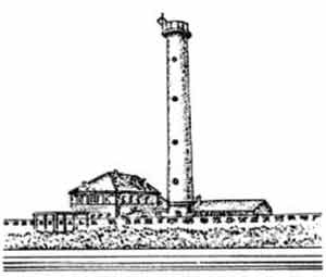
 |
|
Campanile di Caorle, bearing 005°, 1.6 miles |
A burn-off flare at the Marghera refinery is also visible from seaward and is situated in an industrial area, 9 miles NW of the port entrance.
From closer inshore, the prominent belfry standing on Isola Poveglia, 0.6 mile NW of Malamocco, can be identified.
Forte Rocchetta Light is shown from a prominent structure, 23m high, standing on the N side of the entrance, 1.4 miles WNW of the N breakwater head. A mushroom-shaped pilot station tower stands close N of the light.
A racon is situated at the light structure standing on the head of the N breakwater. The entrance channel is marked by articulated lighted beacons. A tower stands 0.7 mile WNW of the light and forms a range which indicates the entrance channel and may best be seen on the chart.
Pilotage. – Pilotage is compulsory. Pilots can be contacted on VHF channel 12 or 13 and board about 2 miles ESE of the N breakwater head.
Requests for pilot services should be made at least 2 hours in advance.
Regulations. – Vessels must contact the pilot station before anchoring.
Vessels should send an ETA and maximum draft at least 24 hours in advance.
Within 2 miles of the port entrance, all other vessels are to give way to vessels which are entering or leaving the port.
Vessels must not pass in the entrance channel; vessels leaving have precedence.
Vessels are not to exceed a speed of 6 knots in Canale Litoraneo.
Anchorage. – There are five designated anchorage areas lying NE of the entrance to Porto di Malamocco. These areas, which have depths of 10 to 18m and may best be seen on the chart, are, as follows:
- Anchorage Area No. 1, centered 1 mile NE of the N breakwater head, is for the use of general cargo vessels of less than 5,000 dwt
- Anchorage Area No. 2, lying close E of Area No. 1, is for the use of tankers or vessels carrying dangerous substances less than 20,000 dwt.
- Anchorage Area No. 3, lying close E of Anchorage Area No. 2, is for the use of tankers or vessels carrying dangerous substances of 20,000 dwt and over.
- Anchorage Area No. 4, lying close N of Anchorage Area No. 3, is for the use of lightering tankers.
- Anchorage Area No. 5, lying close N of Anchorage Area No. 2, is for the use of cargo vessels of 5,000 dwt and over.
Caution. – With strong NE winds and a very strong tidal
current, entry into the port is very dangerous. A dangerous wreck lies about 4.5 miles ENE of the port entrance. A submarine cable lies adjacent to the N side of the entrance channel and anchoring in this vicinity is prohibited.Submarine cables lie across the channel within the harbor and are marked by notice boards on the shore. Anchorage is prohibited in their vicinity.
A submarine pipeline extends 2 miles ESE from a point on the shore, 2 miles NNE of the port entrance. Anchoring and fishing are prohibited in its vicinity.
Shoals and foul ground lie adjacent to the sides of the entrance channel which is subject to silting.
A prohibited area marking an area of works in progress (2006) lies in the entrance channel to Porti di Malamocco and to the S and E of the S entrance breakwater. Mariners must remain at least 50m clear of the area.
Works are in progress (2007) in the area around the ports of Chioggia, Malamocco, and Lido; tidal flow control equipment is being constructed.
Porto di Lido (45°25'N, 12°26'E)
World Port Index No. 40760
19.10 Porto di Lido (Porto di Venezia), the N of the two entrances leading to Porto di Venezia, lies 7 miles NNE of the entrance to Porto di Malamocco and is protected by two breakwaters.
Porto di Venezia Home Page http://www.port.venice.it/
Tides – Currents. – The rates of the tidal currents are variable and may sometimes reach 3 knots. Strong SE winds, at springs, sometimes cause an extraordinary rise of the tide which may flood the quays.
A 36-hour tidal height forecast can be accessed from the Comune di Venezia web page, as follows:
Comune di Venezia – Tidal Height Forecast http://www.comune.venezia.it/maree/en_previsione.asp
Depths – Limitations. – The access channel to Porto di Lido is dredged to a depth of 11m. Canale di San Nicolo leads SW from the entrance to Santa Elena, the E suburb of the city of Venezia. Its SE side is formed by San Nicolo di Lido and its NW side by Le Vignole, a group of three islands. Forte San Andrea, situated on the SE end of this group, is very conspicuous.
Arsenale, a naval installation, is situated at the head of Canale delle Navi, which leads 1.8 miles NW from the W side of Canale di San Nicolo.
Canale di San Marco is entered from the W end of Canale di San Nicolo, S of Santa Elena. It leads NW and W along the S side of the city and connects with Canale della Giudecca in the vicinity of Punta della Salute. Canale di San Marco is quayed as far W as the famed Piazza San Marco, at the N entrance point of Canale Grande. Mooring buoy berths are also situated in this canal and used by large naval, passenger, and cruise vessels.
Canale Orfano, entered from Canale di San Marco SW of Santa Elena, leads to Porto di Malamocco through a network of canals.
Canale della Giudecca, a continuation of Canale di San Marco, leads W to Porto Marittima (Porto Commerciale), the commercial cargo facility at the W side of the city. A turning basin lying SW of Porto Marittima has a depth of 10.4m.
Port Marittima, the commercial harbor for Porto di Venezia, has 3,597m of total berthing space with depths of 8 to 10m alongside. There are facilities for general cargo, passenger, bulk, ro-ro, and container vessels. There are also numerous small craft harbors and marinas within the canal complex.
Aspect. – The buildings of the city of Venezia, situated 3.5 miles W of the port entrance, are mostly obscured, but the belfry of San Marco rises above the city and serves as a good landmark from seaward. The belfry is large and is surmounted by a greenish -colored spire. Also conspicuous is the large Hotel Excelsior, surmounted by two cupolas, which stands near the beach, 2 miles SSW of the port entrance.
A light is shown from a tower, 35m high, standing 3.8 miles NW of the port entrance. This light forms part of a lighted range which indicates the entrance channel and may best be seen on the chart.
A prominent disused signal station stands on the N extremity of San Nicolo di Lido, 2.1 miles WNW of the head of the N breakwater.
A light is shown from a conspicuous structure, 25m high, standing on the head of the N breakwater. A racon is situated at this light.
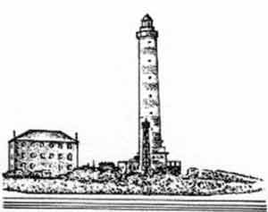 |
|
Piave Vecchia Light |
The entrance channel is marked by lighted buoys; an outer approach lighted buoy is moored about 2.3 miles SE of the head of the N breakwater.
Pilotage. – Pilotage is compulsory for vessels over 500 gross tons. Pilots can be contacted on VHF channel 13.
The pilot boards 2.3 miles SE of the N breakwater head.
Regulations. – Entry regulations for Porto di Lido and Venezia are the same as those for Porto di Malamocco. For further information, see paragraph 19.9.
Vessels carrying inflammable or dangerous cargos bound for Porto Marghera are required to enter through Porto di Malamocco not Porto di Lido.
Vessels should send an ETA and maximum draught 48 hours in advance and contact the pilot at least 2 hours in advance of arrival.
Venice Harbor Control, call sign Venice Pilot, monitors VHF channel 12.
Anchorage. – Two designated anchorage areas, which may best be seen on the chart, lie E of the port entrance. Anchorage Area No. 1 lies centered 2 miles E of the head of the N breakwater and is for the use of cargo vessels of less than 5,000 dwt. Anchorage Area No. 2, lying close E of Area No. 1, is for the use of cargo vessels of 5,000 dwt and over.
There is insufficient swinging room for large vessels to anchor within the port.
Caution. – The entrance to Porto di Lido is subject to silting.
A submarine pipeline extends 2.2 miles S from a point on the shore, 3 miles ENE of the port entrance. The seaward end of this pipeline is marked by a lighted buoy; anchoring is prohibited in its vicinity.
Prohibited areas, marked by lighted buoys, beacons, and piles containing works in progress (2006), lie within Porto di Lido, Canale di San Nicolo, and Canale di Treporti.
Works are in progress (2007) in the area around the ports of Chioggia, Malamocco, and Lido; tidal flow control equipment is being constructed.
Numerous ferries ply within the port and the canals.
Porto di Lido to Punta del Tagliamento
19.11 Porto di Piave Vecchia (45°29'N, 12°35'E) lies at the mouth of Fiume Sile, 7.3 miles ENE of the entrance to Porto di Lido. This small boat harbor is entered between rubble breakwaters and is blocked by shoals. A light is shown from a prominent structure, 48m high, standing near the river mouth. A prominent water tower stands 2.5 miles W of the light.
Caution. – A marine farm, best seen on the chart, is located 1.7 miles S of Porto di Piave Vecchia. It is marked by a lighted buoy.
19.12 The coast between this river mouth and Punta del Tagliamento is backed by two lagoons, Laguna Veneta and Laguna di Caorle. Inland waterways connect these lagoons with Venezia and other ports.
Porto di Cortellazzo lies at the mouth of Fiume Piave, 7 miles ENE of Porto di Piave Vecchia. This river is only navigable by small and light-draft craft with drafts of less than 2.5m. The houses of the village stand near the river mouth and are visible between the tall trees. Three submerged concrete columns, about 50m apart, lie 600m S of the river mouth. This river sometimes deposits a very white-colored and milky substance into the sea which, when seen from a distance, appears as a white and sandy stretch of beach.
19.13 Porto Santa Margherita di Caorle (45°35'N, 12°52'E) lies at the mouth of Fiume Livenza and can only be entered by small boats with drafts of less than 2m. Two jetties form the entrance to the river mouth. Caorle, a conspicuous small town, is situated 1 mile NE of the mouth and is protected by a stone seawall. A prominent campanile stands in this town and another campanile surmounts a prominent church which stands on a point, close NE. A light is shown from the church. A submerged mole extends 0.3 mile SE from a point on the shore, 0.2 mile N of Caorle Light. Its outer end is marked by a red barrel-shaped marker.
Vessels can anchor, in a depth of 12m, mud and sand, about 2 miles offshore, anywhere between the mouth of Fiume Piave and Caorle.
Caution. – A circular area, with a radius of 0.2 mile, where anchoring, stopping, fishing, and all underwater activities are prohibited, lies centered on position 45°3.6'N, 12°52.9'E This is the site of an historic wreck.
Several stranded wrecks lie along this stretch of coast.
19.14 Porto di Falconera lies 1.3 miles ENE of Caorle and consists of the lower reach of Fiume Lemene and Canale Nicessolo. It provides access to Laguna di Caorle, but is obstructed by sand banks and is frequented only by small craft.
Porto di Baseleghe, an inlet at the mouth of Canale dei Lovi, lies 3 miles E of Porto di Falconera and is almost completely obstructed by shoals. It is used only by small craft with local knowledge. A prominent red frame house stands on the shore at the W side of the inlet. The coast between this inlet and Punta del Tagliamento is low and wooded.
Punta del Tagliamento (45°38'N, 13°06'E), located 5 miles E of Porto di Baseleghe, is marked by a light and is fully described in paragraph 20.2.
Caution. – An anchoring and fishing prohibited area, which may best be seen on the chart, lies 11.5 miles S of Punta del Tagliamento.
A circular area, with a radius of 0.2 mile, where anchoring, stopping, fishing, and all underwater activities are prohibited, lies centered on position 45°33.2'N, 13°11.1'E.