SPAIN – CABO DE PALOS TO CABO CERBERE
SECTOR 3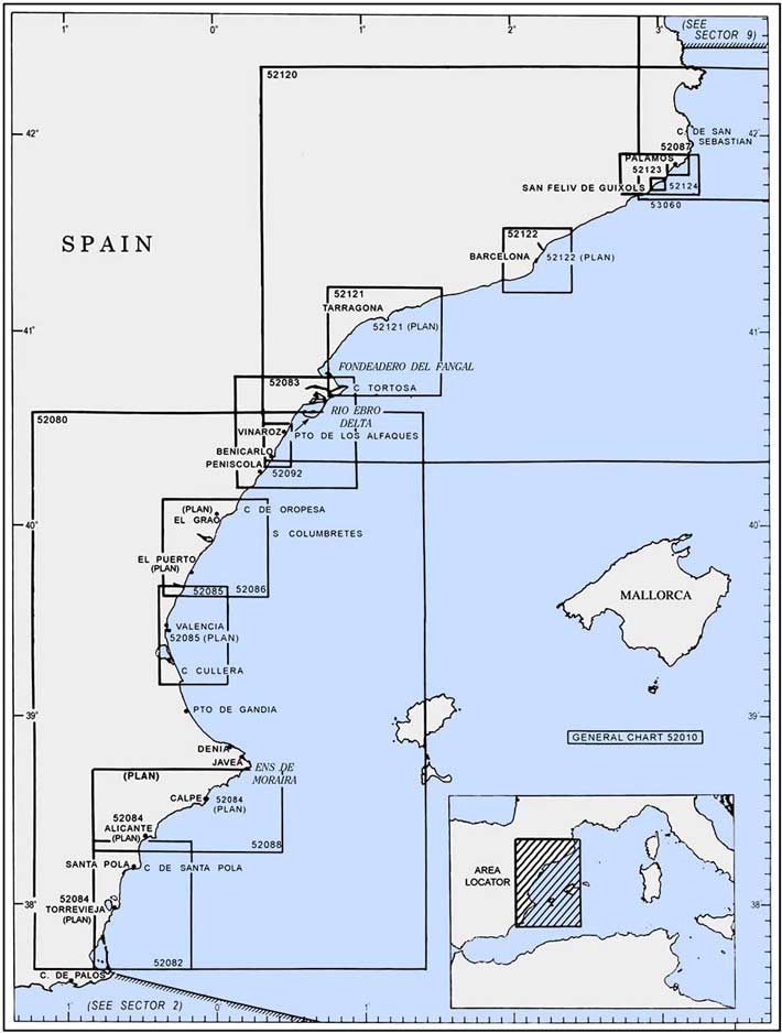
Plan. – This sector describes the E coast of Spain from Cabo de Palos (37°38'N, 0 °41'W) to Cabo Cerbere (42°26'N, 3°11'E), at the border of France; the descriptive sequence is from SW to NE.
General Remarks
3.1 Large stretches of the coast within this sector have been transformed into built-up areas. Many villages, which are situated along the shore, are tourist resorts and are comprised of large prominent buildings and chalets.
Tides – Currents. – Off Cabo de Palos, the E current sets NE. Between this cape and Cabo de San Antonio, the current divides; one branch sets ESE and flows S of Islas Baleares and the other continues NE into Golfo de Valencia.
During E winds, vessels crossing Golfo de Valencia, especially from the N to S, should exercise caution to avoid being set inshore by the current which sometimes attains a rate of 3 knots.
Caution. – Numerous oil field installations, including uncharted drilling platforms, may be encountered along this coast.
Several submarine well heads and obstructions lie off this stretch of coast and may best be seen on the chart. Winds from the NE frequently raise a heavy sea in the vicinity of Islas Columbretes. Submarines frequently exercise off this stretch of coast.
Off-lying Islands and Dangers
3.2 Islas Baleares (38°38'N, 0 °23'E), consisting of four principal islands and several small islets, lie off this section of the coast. Ibiza, the SW island of the group, lies 48 miles ENE of Cabo de San Antonio (38°48'N, 0 °12'E). They are fully described in Sector 4.
A bank, with a least depth of 46m, lies 31 miles E of Cabo de Palos.
Islas Columbretes (39°54'N, 0 °41'E) consists of a small archipelago of volcanic islets and shoals. Columbrete Grande, the NE islet, lies 28 miles ESE of Cabo de Oropesa (40 °05'N, 0 °09'E). The archipelago consists of four groups and one off-lying sunken rock, with deep channels between them. The islets are, in most places, steep-to and generally inaccessible.
Vessels are advised to give this archipelago a wide berth.
Columbrete Grande, the largest islet of the archipelago, is in the form of a crescent and attains heights of 65m and 45m, respectively, at its N and S ends. Its low central part is formed of lava and rock. Three smaller islets lie close E of this large islet.
Monte Colibri Light is shown from a tower with a dwelling, 20m high, standing on the summit near the N end of the islet. A racon is situated at the light.
Lights are also shown from the N and SE extremities of the islet.
Placer de la Barra Alta, a small and rocky shoal, lies about 8 miles SW of the light on Columbrete Grande and has a least depth of 9.3m.
Islote El Bergantin, lying 2.5 miles S of Columbrete Grande, is formed by a conspicuous columnar rock, 32m high. At a distance it appears like a square-rigged vessel under sail. Several dangers lie within 0.5 mile of this rock, except off its W side which is clear and steep-to.
Islote La Horadada lies 1.5 miles N of El Bergantin. This islet is 55m high and several dangers lie within 0.3 mile of it.
La Ferrera (Islote Malaspina), 44m high, lies 1 mile N of La Horadada and is saddle-shaped. Several dangers lie within 0.3 mile of this islet.
Caution. – A marine reserve area, within which fishing and anchoring are prohibited, surrounds the Islas Columbretes and may best be seen on the chart.
A rock, about 400m in length and 100m wide, lies 200m S of La Ferrera. It is covered by a minimum depth of 1.8m and extends in a N to S direction.
Afortunada Oil Complex (40 °42'N, 1°20'E), located 22 miles E of Cabo Tortosa, is described in paragraph 3.31.
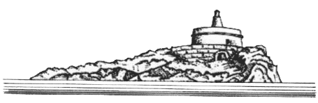
3.3 Cabo de Palos (37°38'N, 0 °41'W) is the seaward extremity of a small peninsula which is joined to the mainland by a narrow isthmus. It is fringed with small rocky islets and is indented. A light is shown from a prominent tower with a dwelling, 51m high, standing on the cape. A racon is situated at the light.
A marine reserve area lies 1.2 miles N of Cabo de Palos; anchoring and fishing are prohibited in this vicinity.
La Barra, a village, is situated on the isthmus and contains numerous prominent resort chalets and buildings.
A submarine cable extends 0.6 mile ESE from the cape to a wave recorder which is marked by a buoy. It was reported (1993) that this buoy was missing. Anchoring and fishing are prohibited in the vicinity of the cable.
 |
Cabo de Palos Light from NE |
El Vivero, a resort, extends along this stretch of coast up to 1 mile NW of the cape and is fronted by a yacht harbor. Several high -rise blocks of flats and hotels stand in the vicinity of the N end of the resort and are conspicuous from seaward.
Regulations. – A Traffic Separation Scheme (TSS) has been established E of Cabo de Palos. The scheme consists of Traffic Lanes, a Separation Zone, and an Inshore Traffic Zone.
Las Hormigas (37°39'N, 0 °39'W), formed by a chain of islets and rocky shoals, extends up to 3 miles NE of Cabo de Palos.
Islas Hormiga, the largest islet of this chain, lies 2.3 miles NE of the cape and is 13m high. A light is shown from a tower with a dwelling, 9m high, standing on the SW extremity of this islet. Bajo de Fuera, the outermost danger of the chain, lies about 0.7 mile NE of Islas Hormiga and has a least depth of 3.8m.
Caution. – Although the channels lying between Las Hormigas are frequently used, they are not recommended for vessels without local knowledge. Vessels rounding the cape are advised to stay clear of the coast and the dangers in this vicinity.
A marine reserve surrounds the islands and is marked by lighted buoys. It should be avoided.
 |
Islas Hormiga Light |
3.4 Punta de Calnegre (37°40'N, 0 °43'W), a rocky point partly covered with sand, is located 2.3 miles NW of Cabo de Palos. A rocky hillock, 43m high, stands close W of it. Two marine farms, best seen on the chart, are located E of the point.
Isla Grosa (37°44'N, 0 °42'W), 95m high, lies 1.5 miles offshore, 3.7 miles NNE of Punta de Calnegre. This island is high, steep-sided, and flat-topped. A light is shown from a structure standing on the summit. Anchorage, sheltered from E winds, can be obtained by vessels with local knowledge, in a depth of 8.2m, weed, about 0.4 mile W of the island.
Islote El Farallon is located 0.4 mile E of the NE extremity of Isla Grosa. This islet is 22m high and has a sharp pointed summit. La Laja, a small rocky patch, lies about 0.3 mile NE of this islet and has a least depth of 1.3m.
Punta del Estacio (37°45'N, 0 °43'W) is located 7 miles NNW of Cabo de Palos. It is formed by the low and rocky SE extremity of a small peninsular which projects from the coast. A light is shown from a tower, 29m high, standing on the point. A coast guard hut and several other buildings are situated near the light tower. An extensive yacht harbor, protected by a breakwater, is situated close W of this point at the main entrance to Mar Menor.
Mar Menor, a large salt water lagoon, is enclosed by the coastal barrier which extends NNW from Cabo de Palos. Several small yacht harbors are situated within this lagoon.
Cerro del Cabezo Gordo (37°48'N, 0 °54'W), 312m high, is an isolated and conspicuous hill. When seen from NE, it has some resemblance to Isla Grosa and care should be taken, especially in misty weather, to avoid mistaking this hill for the island.
San Pedro del Pinatar (37°49'N, 0 °45'W), a village, is situated 5 miles NNW of Punta del Estacio. An L-shaped mole fronts the village and forms a small harbor. The inner side of the mole is quayed. It provides 137m of berthing space with a depth of at least 4.9m, and 168m of berthing space with depths of 2.7 to 4.6m alongside.
Several prominent buildings associated with the growth in the tourist trade have been constructed in the vicinity of the village. A conspicuous windmill is reported (1993) to stand 1.5 miles S of the harbor.
Torre de la Horadada stands on a rocky headland, 2.7 miles N of San Pedro del Pinatar. A refuge harbor for small craft, protected by a breakwater, is situated close SW of this tower. Two fish havens marked by lighted buoys, best seen on the chart, are found 2 miles E of the breakwater.
Cabo Roig (37°54'N, 0 °43'W) is a conspicuous reddish headland surmounted by a tower and a coast guard hut. A yacht marina is situated close W of this cape.
Punta Prima (Punta Delgada) is located 2 miles NNE of Cabo Roig. Several small coves lie between these points.
3.5 Torrevieja (37°58'N, 0 °41'W) (World Port Index No. 38435), a small port, lies 2 miles NNE of Punta Prima and is protected by breakwaters. The entrance is 250m wide and has a depth of 11m. The main quays have 350m of berthing space with a depth of 9.5m alongside, and 266m of berthing space with a depth of 8m alongside. Vessels up to 180m in length and 9m draft have been accommodated. An extensive yacht marina is situated in the N part of the harbor. Pilotage is compulsory. Pilots can be contacted on VHF channel 12 or 16 and board 0.6 mile S of the entrance. Anchorage can be obtained, in depths of 12 to 14m, about 0.5 mile SE of the head of the breakwater and is best seen on the chart. An anchorage for vessels carrying hazardous materials is located further seaward as shown on the chart Several mooring buoys are situated within the harbor.
Cabo Cervera (38°00'N, 0 °39'W), located 2.3 miles NE of Torrevieja, is low and surmounted by a the ruins of a tower.
An aeronautical light is shown from a prominent radio tower standing 0.7 mile inland, 4.2 miles NNW of Cabo Cervera.
The prominent town of Guardamar del Segura is situated at the foot of a hill, 5 miles N of Cabo Cervera. The hill is surmounted by the ruins of a castle. An obstruction area, within which fishing is prohibited, lies 2 miles E of the town and may best be seen on the chart.
Sierra de Callosa (38°07'N, 0 °54'W), rising to a height of over 570m about 12 miles WNW of Guardamar, is rugged, dark in color, and easy to identify from seaward.
3.6 Bahia de Santa Pola (38°07'N, 0 °37'W) lies between Torre de Pinet, situated 4.5 miles N of Guardamar, and Cabo de Santa Pola, 6 miles ENE. It affords good shelter from winds SW through NE, but care is necessary and local knowledge is advised for entering.
 |
Sierra de Callosa bearing 331°, distant 30 miles |
Several fish havens lie in the bay and depths of less than 9m extend up to as far as 1.2 miles from shore. Fondeadero de Tamarit, in the NW part of the bay, affords anchorage, in depths of 5 to 6m, weed, but local knowledge is required.
Santa Pola (38°11'N, 0 °34'W), a town, stands on the N shore of the bay and is fronted by a small harbor which is protected by breakwaters. A prominent two-story customs house stands on outer breakwater. A small commercial quay has depths of 2.8 to 5m alongside and is used by coasters. Anchorage may be taken, in depths of 6 to 7m, weed, about 0.2 mile S of the entrance. Larger vessels may anchor, in depths of 12 to 14m, farther SE.
Isla de Tabarca (38°10'N, 0 °28'W), lying 3 miles SSE of Cabo de Santa Pola, is low and level. Bajo del Oeste, a rock, lies about 0.5 mile WNW of the W end of the island and has a least depth of 4.2m.
Freu de Tabarca, the channel leading between the island and Cabo de Santa Pola, should not be attempted by vessels with deep drafts or by vessels without local knowledge.
The N and S sides of Isla de Tabarca are fronted by rocks. A light is shown from a tower, 11m high, standing near the E end of the island.
Caution. – A submarine water pipeline extends ESE between the Cabo de Santa Pola and Isla de Tabarca. Anchoring and fishing are prohibited in the vicinity of this pipeline.
Islote de la Nao, an islet, is located 0.3 mile ESE of the E end of the island. Bajo de la Nao, a rock with a least depth of 3.7m, lies about 0.8 mile ESE of this islet and is marked by a lighted buoy.
A stranded wreck lies 0.7 mile ESE of the breakwater to Santo Pola. The wreck is marked by a lighted buoy.
A marine reserve area surrounds the waters in the vicinity of Isla de Tabarca. Its limits are marked by lighted buoys and may best be seen on the chart.
3.7 Cabo de Santo Pola (38°13'N, 0 °30'W) is moderately high and of a reddish color. From the N or S, it first appears as a flat projection ending in a steep slope. On nearer approach, the level ground at the foot of the slope comes into view. A light is shown from a metal structure surmounting a tower, 15m high, standing on the crest of the slope.
Bahia de Alicante (38°20'N, 0 °28'W) lies between Cabo de Santa Pola and Cabo de las Huerta, 10 miles NE. This bay is easily identified by the mountains and hills in its vicinity. Its shores may be safely approached to within about 1 mile.
A submarine pipeline (gas) lies 5 miles N of Cabo de Santa Pola and is marked by a lighted buoy at its seaward extremity. Several gas storage tanks stand near the shore of the bay, W of this terminal. It is reported (1994) that vessels up to 140m in length and 8.5m draft can be handled here.
A yacht harbor, protected by breakwaters, is situated in the NE part of the bay at Albufereta, 2 miles W of the cape.
World Port Index No. 38440
3.8 The port of Alicante lies in the NW part of Bahia de Alicante, 4 miles WSW of Cabo de las Huerta. It is protected by Dique de Abrigo de Levante, a breakwater, which extends 0.4 mile SSE and then 0.8 mile SW.
Port of Alicante Home Page http://www.puertoalicante.com
Tides – Currents. – The tides at the port are negligible.
Depths – Limitations. – The port consists of an inner harbor and an outer harbor. The approach channel is dredged to a depth of 14.5m. A yacht marina is situated on the N side of the inner harbor.
There is 1,437m of total main berthing space, with depths of 3.6 to 8.1m alongside, within the inner harbor. There is additional berthing space, with depths of 6.8 to 11m alongside, within the outer harbor as shown in the table below.
| Alicante – Berthing Information | |||
|---|---|---|---|
| Berth | Length | Depth | Remarks |
| Muelle 12 | 296m | 8.0m | General cargo |
| Muelle 11 | 360m | 11.0m | Tanker and containers |
| Muelle 10 | 203m | 6.0 -8.7m | General cargo |
| Muelle 9 | 103m | 8.7m | General cargo |
| Muelle 7 | 240m | 8.7m | Fishing vessels |
There is 970m of additional space at Muelle 14, with depths of 8 to 12.5m alongside, on the inner side of Dique de Abrigo de Levante, the main breakwater.
In addition, there is a new quay, Muelle 17, which extends SW on reclaimed land, from the outer harbor. It has a berth, 306m long, with a depth of 14.5m alongside.
There are facilities for passenger, general cargo, bulk, ro-ro, tanker, container, and fishing vessels. Vessels up to 243m in length and 14.3m draft can be accommodated.
Aspect. – The port may be easily identified by the prominent mountains and hills in its vicinity. Sierra de Fontcalent, 446m high, stands 5 miles W of the harbor. Sierra de Jijona, 1,230m high, stands 10.5 miles NNE of Sierra de Fontcalent.
Castillo de Santa Barbara surmounts a conspicuous hill, 179m high, which stands in the NE part of the city, 0.3 mile N of the root of the main breakwater. Cerro de San Julian, 1 mile NE of Castillo de Santa Barbara, attains a height of 181m.
An aeronautical light is shown at an airport, 4.5 miles SW of the harbor entrance.
Pilotage. – Pilotage is compulsory for vessels over 500 grt. Pilots may be contacted on VHF channel 14 or 20 and board vessels about 1 mile S of the harbor entrance.
Anchorage. – Anchorage may be taken, in a depth of 16m, good holding ground, about 0.5 mile off the outer breakwater. In winter, with strong NW winds, vessels may drag if anchored too far offshore.
3.9 Cabo de las Huerta (38°21'N, 0 °24'W), located 4 miles ENE of Alicante, terminates in a low point. A hill rises close NW of the cape and is a prominent whitish color. A reef, with a depth of less than 5m over its seaward end, extends up to 0.3 mile E of the cape. A light is shown from a tower, 8m high, standing on the cape. During NW winds, anchorage can be obtained off Playa de las Huertas, which extends as far as 3.5 miles N of the cape.
Villajoyosa (38°30'N, 0 °14'W), a small harbor, is situated 13 miles NE of Cabo de las Huerta. It is protected by breakwaters and is mostly used by fishing boats. A yacht marina is situated within this harbor.
Cabezo del Tosal (38°31'N, 0 °10'W), a small promontory, is located 2.8 miles ENE of Villajoyosa. It is conspicuous, whitish in color, and surmounted by a coast guard station.
Ensenada de Benidorm lies between Cabezo del Tosal and Punta de la Escaleta, 3 miles E. This bay affords shelter from NW and NE winds.
Islote de Benidorm (38°30'N, 0 °48'W) lies 2 miles SW of Punta de la Escaleta. It is cliffy, barren, and reddish. A flat, whitish, and rocky shoal, with a least depth of 5.8m, extends 200m in a NNE to SSW direction and should be given a wide berth by deep draft vessels. This shoal lies 0.2 mile S of this island. A light is shown from a tower, 4m high, standing on the island.
Benidorm (38°32'N, 0 °08'W) (World Port Index No. 38437), a resort town, is situated at the head of Ensenada de Benidorm. It has numerous tall buildings and surrounds a rocky point, which is surmounted by a conspicuous church with a blue dome. Anchorage, during offshore winds, can be obtained, in depths of 20 to 26m, muddy sand and weed, about 0.4 mile SW of the church.
Caution. – The head of a small mole, which fronts the town, should be given a wide berth due to submerged foundations. Considerable silting has also taken place in its vicinity.
Tunny nets are laid out annually in the E part of Ensenada de Benidorm. A fishing prohibited area, the limits of which are shown on the chart, lies centered 1 mile NNE of Islote de Benidorm.
3.10 Sierra Helada (38°33'N, 0 °05'W), a range of hills, extends 3 miles NE of Punta de la Escaleta. When seen from the SW or NE, it presents a steep slope on the seaward side and a gradual decline on the inland side.
Islote Mediana (Isla Mitjana) lies close inshore, 1.5 miles NE of Punta de la Escaleta. It usually cannot be distinguished against the cliffs, except from a short distance.
Punta del Albir (38°34'N, 0 °03'W) is located 2 miles NE of Islote Mediana. A light is shown from a tower with a dwelling, 8m high, standing on the point.
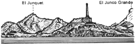
Puig Campana, the most conspicuous mountain along this part of the coast, rises to a height of 1,436m, 7 miles WNW of Punta del Albir. When seen from the SSE, this mountain can easily be identified by Cuchillada de Roldan, a large and deep ravine lying between its summit and another peak, 1,366m high, standing 0.5 mile SW.
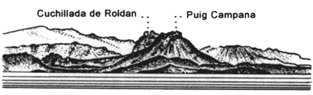 |
Cuchillada de Roldan bearing 347°, distant 12 miles |
3.11 Altea (38°36'N, 0 °03'W), a town, is situated 2 miles N of Punta del Albir. It is marked by a prominent church with high blue and white cupolas. A small harbor, which includes a yacht marina, is situated 0.5 mile SSW of the town and is protected by breakwaters. Anchorage can be obtained, in depths of 16 to 20m, mud, 0.5 mile E of the harbor entrance.
A dangerous wreck lies about 0.4 mile SSE of the harbor entrance.
Islote de Altea lies 0.2 mile offshore, 2.5 miles NE of the harbor. A reef extends between this islet and the mainland. A small yacht harbor, protected by a breakwater, is situated 1 mile NE of the islet.
A dangerous wreck lies about 0.7 mile S of the islet. Numerous fish havens, best seen on the chart, are located in the Ensenada de Altea.
Ensenada de Calpe is entered between Cabo Toix, whose summit is topped by a television relay tower, located 5 miles NE of Punta del Albir, and Punta Ifach, 2.5 miles ENE. A small craft harbor, protected by breakwaters, is situated close NW of Punta Ifach.
Punta Ifach is formed by the E extremity of Monte Ifach, a peninsula, which somewhat resembles the Rock of Gibraltar. Its seaward sides are formed by high, reddish cliffs and the land to the NW of it is very low. When seen from the SW or NE, it appears as an island.
During good weather, anchorage can be obtained, in a depth of 12m, sand and weed, within Ensenada de Calpe, about 0.3 mile offshore. During W or SW winds, anchorage can also be obtained, in a depth of 26m, sand and mud, off Playa de la Fosa, about 0.6 mile N of Punta Ifach.
Caution. – A dangerous wreck lies 0.5 mile from land in the center of the bay in front of Ensenada de Calpe.
Punta de Las Basetas, located 1.2 miles N of Punta Ifach, is surmounted by a large tower.
3.12 Cabo Blanco (38°40'N, 0 °07'E), located 3 miles NE of Punta Ifach, slopes steeply down to the sea. The high land standing above this cape is surmounted by a tower.
Ensenada de Morayra lies between Cabo Blanco and Cabo Morayra, 1.7 miles ENE. A yacht harbor, protected by breakwaters, is situated close W of Cabo Morayra. This bay affords shelter from W, N, and E winds. Vessels may anchor, in a depth of 16m, sand or mud, about 0.5 mile WNW of Cabo Morayra.
Monte Isabela, 442m high, stands 3 miles NNE of Cabo Morayra. This hill is conical in shape and easy to identify.
Several marine farms have been established within the bays lying NE and W of Punta Ifach. These farms are protected by artificial reefs and fishing is prohibited in their vicinity. Vessels anchoring in the bays should have local knowledge.
Cabo de la Nao (38°44'N, 0 °14'E), located 5 miles NE of Cabo Morayra, is fairly steep-to. A large rock lies at its foot, near a cave. A light is shown from a tower with a dwelling, 20m high, standing on the cape. A radiobeacon is situated at the light.
Isla del Descubridor, 57m high, lies close offshore, 1 mile WSW of the cape. The narrow channel lying between this island and the mainland cannot be used.
Cabo Negro, located 1 mile N of Cabo de la Nao, is sheer cut and fronted by rocks. Isla del Portichol, 68m high, lies close offshore, 0.7 mile N of this cape.
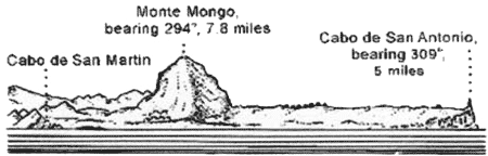
Cabo de San Martin, located 1.2 miles N of Cabo Negro, has a steep-sided hillock standing at its extremity.
Javea (38°48'N, 0 °11'E), a small harbor, is situated within a bay, 2.4 miles NNW of Cabo de San Martin. It is protected by two breakwaters and is used by small craft and yachts. Anchorage can be obtained, in depths of 14 to 20m, sand, E of the harbor.
Caution. – Submarine cables extend E from a point on the shore lying close S of Javea.
 |
Ensenada de Javea |
3.13 Cabo de San Antonio (38°40'N, 0 °12'E), located 0.7 mile ENE of Javea, is formed by a high and level promontory which falls steeply towards the sea. A light is shown from a tower with a dwelling, 17m high, standing on the E extremity of the cape.
A signal station is situated near the light and a hermitage stands close SSW of it. Several windmills stand on a ridge, 1.2 miles W of the cape.
Monte Mongo (38°48'N, 0 °08'E), 752m high, has a conical peak surmounted by a castle. This hill is conspicuous and from a distance appears as an island. During E or NE winds, it generally becomes obscured by clouds.
Ibiza (38°55'N, 1°20'W), the nearest island of the Islas Baleares, lies 48 miles ENE of Cabo de San Antonio and is described in paragraph 4.6.
3.14 Denia (38°50'N, 0 °07'E), a small port, lies 4.7 miles WNW of Cabo de San Antonio and is protected by two breakwaters.
Depths – Limitations. – The entrance channel is dredged to a depth of 5m. The main quay is 208m long and has a depth of 5.5m alongside. Vessels up to 100m in length and 5m draft can be accommodated. The port is mostly used by pleasure craft, yacht, and vehicular ferries.
Aspect. – Castillo de Denia stands on a hill near the NW end of the harbor. The prominent spire of the church and the square-topped belfry of another church stand close SE and SW, respectively, of the castle. Several high -rise buildings are situated in the vicinity of the town and are conspicuous from seaward.
A lighted range indicates the entrance channel.
Pilotage. – Pilotage is compulsory for vessels over 50 grt. Pilots can be contacted on VHF channel 16 and board in position 38°52'N, 8°53'E Vessels should send their ETA at least 6 hours in advance and request a pilot from Gandia.
Anchorage. – Vessels up to 91m in length may anchor within the harbor. Larger vessels may anchor, in depths of 12 to 18m, in the roadstead, or in a depth of 26m, mud, about 0.8 mile NE of the N breakwater.
Caution. – Bajo La Androna, a shoal with a least depth of 3.4m, lies close N of the head of the S breakwater and projects into the entrance channel.
An outfall pipeline extends from the shore on the NW side of the harbor. Its seaward end is marked by a buoy.
3.15 Algar de la Almadraba (38°55'N, 0 °02'E), centered about 6 miles NW of Denia, is an extensive area of foul ground which lies off this stretch of coast. This area has depths of 25 to 36m and heavy seas are raised over it by onshore winds.
Oliva (38°55'N, 0 °07'W), a conspicuous town, stands at the foot of a small hill, 12 miles NW of Denia. Two small piers, with depths of 3m alongside, extend from the coast adjacent to this town.
Torre de Piles stands near the beach, 2 miles N of Oliva. Several prominent buildings are situated near this tower. It was reported (1990) that the tower was not visible from seaward.
World Port Index No. 38460
3.16 Gandia, a small port, lies at the mouth of the Rio San Nicolas, 20 miles NW of Cabo de San Antonio. It is protected by two breakwaters.
Depths – Limitations. – The entrance to the harbor is about 100m wide, with a depth of 9m. An extensive yacht marina is situated in the N part of the harbor.
Information concerning the main commercial facilities are given in the accompanying table.
| Gandia – Berthing Information | |||
|---|---|---|---|
| Berth | Length | Depth | Remarks |
Muelle Sur |
150m | 6.0m | General cargo |
Muelle Norte |
125m | 5.5m | General cargo |
Muelle Frutero |
300m | 5.5m | General cargo |
Muelle Serpis |
300m | 9-10m | General cargo. Ro-ro vessels. |
Muelle Sur extension |
150m | 6.5m | General cargo |
Moto-Veleros |
174m | 4.5m | Fishing vessels |
There are facilities for general cargo, bulk, and ro-ro vessels. Vessels up to 107m in length and 5.5m have been accommodated.
Aspect. – El Mitjanet, a rocky patch, with a least depth of 5.6m, lies about 0.5 mile N of the harbor entrance. It extends parallel with the coast and about 0.4 mile offshore.
The town of Gandia is situated on the N bank of the Rio Serpis in the middle of a cultivated plain, 1.5 miles SW of the harbor.
Pilotage. – Pilotage is compulsory as local knowledge is essential due to shifting shoals near the entrance. Pilots board about 0.5 mile off the harbor entrance and can be contacted on VHF channel 16.
Anchorage. – Anchorage can be obtained, in a depth of 20m, 1.2 miles ENE of the head of the N breakwater. Due to El Mitjanet, extreme care should be taken.
Caution. – Fish havens front the port to the E and NE as best seen on the chart.
A dangerous wreck lies 4.5 miles NNE of the N breakwater light at Puerto de Gandia.
3.17 La Vinyeta (39°04'N, 0 °11'W), an area of rocky patches, extends between Gandia and the Rio Jucar, 10 miles NNW. It lies up to 1 mile offshore and has depths of 10 to 20m.
From Gandia to Valencia, the coast is low and sandy, with the exception of Cabo Cullera, and generally may be approached to within 1 mile.
Torre La Vall and Torre de Jucar stand 6.2 and 9.7 miles NW, respectively, of Gandia. Several buildings are situated in the vicinity of these towers. It is reported (1990) that these towers are not visible from seaward.
El Moro, marked by a beacon, is a small above-water rock which lies about 0.6 mile NNE of the mouth of the Rio Jucar. During offshore winds, anchorage may be taken, in a depth of 6m, about 0.3 mile N or S of El Moro.
The Rio Jucar is shallow and its mouth encumbered by a bar. Two jetties extend 0.2 mile seaward from the mouth of the river.
Monte de las Zorras (39°10'N, 0 °15'W), 222m high, is prominent and stands just S of Sierra de Cullora, a range, which rises steeply from the plains.
Cabo Cullera (39°11'N, 0 °13'W) rises steeply from the sea and is the E extremity of Sierra de Cullera. A light is shown from a tower, 16m high, standing on the cape.
A small yacht harbor, protected by breakwaters, is situated 0.5 mile SW of the cape.
Santos de Sucia Hermitage stands 2.5 miles inland, 5.7 miles NW of Cabo Cullera. It is situated on a prominent hill, 38m high, in the middle of the coastal plain and is conspicuous.
Casa del Rey, where several prominent buildings stand, is located 4 miles NW of Cabo Cullera. Penas del Moro, a rocky and shallow reef, extends up to 0.3 mile offshore, about 0.5 N of Casa del Rey.
El Perello, a small yacht harbor, is situated 6 miles NNW of Cabo Cullera and protected by breakwaters.
La Albufera de Valencia (39°20'N, 0 °21'W), a shallow lake, lies just inland behind the coastal sand banks. Caserio El Saler, a small village, is situated at its N end. A small, square tower stands in the village and is visible from seaward.
Caution. – Dangerous wrecks lie 1 mile NE of Cabo Cullera and 2 miles E of Gola del Perello.
World Port Index No. 38480
3.18 The port of Valencia lies 17 miles NNW of Cabo Cullera and is protected by breakwaters. It is backed by a prominent city which stands on a plain, 2 miles inland.
Port of Valencia Home Page http://www.valenciaport.com
Depths – Limitations. – The Rio Turia, which formerly flowed through the N part of the city, was diverted and now enters the sea 1.4 miles WSW of the harbor entrance. An extensive marina, protected by rubble breakwaters, lies close N of this new river mouth. A small craft harbor, consisting of two basins, is situated 0.4 mile N of the marina.
Muelle de Levante extends 0.9 mile SSE from the shore at the N side of the port. Dique de Norte extends about 0.5 mile E from the SE end of Muelle de Levante. Dique del Este extends 0.6 mile S from the E end of Dique de Norte. The harbor entrance, 600m wide, lies between the S end of Dique de Este and a rubble breakwater, which is part of the Muelle Darsena Sur to the SW.
The entrance fairway is 500m wide and dredged to a depth of 16m.
The main berthing facilities are described in the accompany table titled Valencia – Berthing Information.
The port has facilities for ro-ro, container, general cargo, bulk, passenger, and tanker vessels. Vessels of up to 65,000 dwt, 290m in length, and 13.2m draft have been accommodated within the harbor.
Aspect. – Islas Columbretes (39°54'N, 0 °41'E), previously described in paragraph 3.2, lie in the outer approach to the port and form a good landmark.
A lighted buoy is moored about 0.4 mile S of the head of Dique del Este. A light is shown from a prominent tower, 22m high, standing on the E end of Dique de Norte.
|
|||||||||||||||||||||||||||||||||||||||||||||||||
An aeronautical radiobeacon is situated 2 miles W of the harbor entrance.
Pilotage. – Pilotage is compulsory. Pilots can be contacted on VHF channel 11, 12, 14, or 16 and board about 1.5 miles SE of Nuevo Dique del Este.
Anchorage. – Vessels may anchor off the harbor entrance in the charted area, but must keep the approach clear. Good holding ground is found, in a depth of 18m, about 1 mile SE of the light.
An anchorage area for vessels carrying dangerous cargo is located about 2.5 miles SE of the head of the breakwater and is best seen on the chart.
Caution. – The harbor and entrance channel are subject to silting.
Winds from the NE usually cause a heavy swell to set WSW across the entrance of the harbor.
Due to the existence of submarine cables, a prohibited anchoring and trawling area, the limits of which are shown on the chart, extends up to 13 miles seaward from a point on the shore lying close N of the harbor.
Outfall pipelines extend ESE from the mouth of the Rio Turia; they extend up to 2 miles seaward. It is reported (1997) that extensive works are being carried out within the harbor.
3.19 Torre de Puig (39°35'N, 0 °17'W) stands 7.5 miles N of Valencia. A coast guard station is situated close to this tower. A prominent convent stands on the slope of a hill, 1.5 miles WNW of the tower.
From Valencia to Sagunto, the coast is formed by a sandy beach backed by an almost continuous line of villages. Puerto de Alboraya and Puerto de Farnais are small craft harbors which are situated 3 miles and 6 miles N, respectively, of Valencia.
Algar de Albuixech, Algar del Puig, and Algar de Murviedro are areas of rock and weed, with depths of 15 to 20m, which lie off this stretch of coast.
Grao de Murviedro, where a number of warehouses are situated, is located 4 miles NNE of Torre de Puig and fronted by a reef. Anchorage, with local knowledge, can be obtained, in depths of 10 to 12m, sand, off Grao de Murviedro.
World Port Index No. 38490
3.20 The small port of Sagunto (Puerto de Sagunto) lies 12 miles NNE of Valencia and is privately owned. It consists of a harbor basin, which is protected by a breakwater, and an outer ore terminal. It has been reported (1994) that extensive reclamation is in progress on the outer boundary of the Escollera de Levante.
Depths – Limitations. – Escollera de Levante, the main breakwater, extends 0.6 mile SSE from the N side of the harbor basin.
The main facilities include Muelle Norte, 570m long, with a depth of 9.8m alongside; Muelle Centro, 660m long, with a depth of 11.2m alongside; and Muelle Sur, 580m long, with a depth of 9.8m alongside. There are facilities for ro-ro and bulk vessels.
Pantalan, the ore terminal, consists of a pier, with a loading platform at its head, which extends 0.8 mile ESE from near the root of the main breakwater. The platform berth can accommodate vessels up to 90,000 dwt and a draft of 14m.
The entrance channel, about 100m wide at its narrowest, is dredged to 9.5m and is marked by lighted buoys.
Aspect. – The port area is easily recognized from offshore by the existence of several industrial installations.
Pilotage. – Pilotage is compulsory. Pilots can be contacted on VHF channel 12 or 16 and generally board vessels about 1 mile SE of the harbor entrance.
Anchorage. – Anchorage may be taken, in depths of 20m or more, good holding ground, E to SE of the ore pier.
A designated dangerous cargo anchorage lies about 5 miles S of Cabo Canet.
Caution. – A shoal area, with a least depth of 1.6m, extends W from the W side of the breakwater and lies adjacent to the entrance channel.
An isolated patch, with a depth of 4.5m, lies about 0.2 mile S of the head of the breakwater.
Winds from the N or E may be strong enough to cause a troublesome swell in the harbor entrance and prevent entry or exit.
3.21 Cabo Canet (39°40'N, 0 °12'W), low and sandy, is located 1 mile NNE of Sagunto. A light is shown from a prominent tower, 30m high, standing 0.2 mile inland of the cape.
A small yacht harbor is situated close N of the cape. Sierra de Almenara, 186m high, stands inland, 5 miles N of the cape. This hill is crowned by a castle and a tower which can be seen from seaward.
A marine farm, marked by lighted buoys, lies close NE of the ore loading platform at Sagunto.
An outfall, marked by a buoy, lies 1 mile N of Cabo Canet. Fish havens front the coast between Cabo Canet and Bajo Punta La Llosa and are best seen on the chart.
Bajo Punta La Llosa, with a least depth of 5.5m, lies 1.5 miles offshore, about 4.5 miles NNE of Cabo Canet.
Pico Espadan, 1,105m high, stands 13 miles inland, 16 miles NNW of Cabo Canet. This mountain is the most conspicuous distant landmark along this stretch of coast.
3.22 Burriana (39°53'N, 0 °03'W) (World Port Index No. 38495), a small port, lies 13 miles NE of Cabo Canet and is protected by breakwaters.
Depths – Limitations. – The harbor entrance has a depth of 6m.
The main facilities include Transversal Quay, 180m long, with a depth of 5.5m alongside, and Levante Quay, 400m long, with a depth of 5m alongside. Vessels up to 150m in length and 5.2m draft can be accommodated.
Aspect. – The prominent town of Burriana stands on the S bank of the Rio Bechi, 1.5 miles N of the harbor.
Pilotage. – Pilots are available and generally board vessels about 1 mile from the harbor entrance. The port can be contacted on VHF channel 16.
Anchorage. – Vessels can anchor, in a depth of 10m, about 0.2 mile S of the head of the E breakwater. Caution. – A sandy shoal, with a depth of 3.3m, lies about 0.5 mile SW of the head of the E breakwater.
Stony patches, with depths of 2.7m and 3m, lie about 0.6 mile NE and 0.9 mile NNE, respectively, of the head of the E breakwater.
Several wrecks and a triangular fish haven lie in the approach to the harbor and may best be seen on the chart.
3.23 Puerto de Castellon Oil Terminal (39°56'N, 0 °03'E) is situated offshore, 7 miles NE of Burriana. It consists of an offshore sea berth, formed by mooring buoys, lying at the seaward end of a submarine pipeline, which extends 2.5 miles ESE from the shore. In addition, a berthing platform is situated along this pipeline, 1.2 miles from the shore.
Port of Castellon Home Page http://www.portcastello.com
Depths – Limitations. – Vessels of unlimited length, with drafts up to about 12.5m, can be accommodated at the berthing platform. Vessels of unlimited length, with drafts up to 19.8m, can be accommodated at the sea berth.
Aspect. – The sea berth is marked by a lighted buoy moored about 0.5 mile E of it. In addition, two lighted buoys are moored about 0.5 mile N of the seaward end of the pipeline.
Pilotage. – Pilotage is compulsory. Vessels should send an ETA 72 hours and 24 hours in advance.
Pilots can be contacted on VHF channel 13 or 16 and board, as follows:
- Sea berths – near Outer Lighted Buoy.
- Platform – about 0.5 mile NE of the platform. If possible, vessels should maintain a continuous listening watch on VHF channel 13.
Anchorage. – Vessels may anchor, in a depth of about 30m, seaward of Outer Lighted Buoy. The holding ground is reported to be good.
Caution. – Navigation is prohibited between the outer approach lighted buoy and the berthing platform, except for vessels berthing. Small craft may pass between the berthing platform and the shore, but must not anchor or fish in the vicinity of the pipeline.
3.24 El Grao (Puerto de Castellon) (39°58'N, 0 °01'E) (World Port Index No. 38500), a small port, lies 8 miles NNE of Burriana and is protected by breakwaters.
Depths – Limitations. – A basin, with a depth of 4.1m, lies on the SW side of the harbor and is used by fishing vessels. In addition, a yacht marina is situated within the harbor.
There are depths of 6.8 to 8m alongside the quays in the commercial basin. Vessels up to 201m in length and 9.9m draft have been accommodated in the outer harbor.
Aspect. – The prominent town of Castellon de la Plana stands in the middle of a plain, 2.5 miles WNW of the harbor, and is visible from seaward.
A light is shown from a structure, 27m high, standing on the head of the E breakwater.
A conspicuous flare is emitted from a chimney, 75m high, which stands 1.7 miles SW of the harbor entrance. The buildings, tanks, and chimneys of an oil refinery and a heating plant, which are situated in the vicinity of the flare, are prominent from seaward.
Pilotage. – Pilotage is compulsory. Pilots may be contacted on VHF channel 12 or 16 and board close off the breakwaters.
Anchorage. – Anchorage can be obtained, in depths of 11 to 13m, fair holding ground, E of the head of E breakwater. This anchorage is completely exposed and vessels are advised to put to sea on the approach of bad weather.
3.25 Torre de Benicasim (40 °03'N, 0 °04'E) stands on the coast, 5 miles NNE of El Grao. The prominent town of Benicasim stands at the foot of a hill, 1 mile NW of this tower.
Olla de Benicasim, a roadstead, lies off Torre de Benicasim. Anchorage can be obtained, in depths of 7 to 11m, between 0.6 mile and 1 mile offshore.
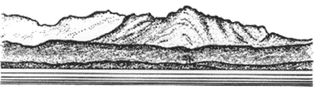
Cabo de Oropesa (40 °05'N, 0 °09'E), located 9 miles NE of El Grao, is the low termination of Los Colls, a range of mountains with three conspicuous peaks. A light is shown from a tower with a dwelling, 13m high, standing on the cape. An old watch tower stands close to the light.
Caution. – Several marine farm areas, the limits of which are shown on the chart, lie offshore between Cabo de Oropesa and Peniscola.
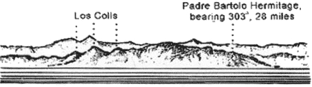 |
Los Colls from SE |
Several wrecks and obstructions lie E to SE of Benicasim from 2 to 3 miles off the coast.
3.26 Torre de Almadun (40 °19'N, 0 °22'E), standing 17 miles NE of Cabo de Oropesa, is conspicuous.
Peniscola (40 °21'N, 0 °24'E), located 3 miles NE of Torre de Almadun, is a small and rocky fortified peninsula. It is 64m high and the summit is surmounted by a large, ancient, and conspicuous castle. Peniscola Light is shown from a tower with a dwelling, 11m high, standing on the SE wall of the castle.
Small vessels can anchor, in a depth of 6m, close N of the peninsula. This berth is sheltered from SW winds, but is exposed to E winds.
Puerto de Peniscola, a small craft harbor, lies SW of the peninsula and is protected by a breakwater.
Puerto de Benicarlo, a small harbor, lies 4.6 miles NE of Puerto de Peniscola. It is protected by breakwaters, but is subject to silting. Anchorage, exposed to onshore winds, can be obtained, in depths of 5 to 12m, about 0.7 mile E of the harbor. The harbor is used by pleasure craft, fishing vessels, and small coasters.
3.27 Vinaroz (40 °28'N, 0 °29'E) (World Port Index No. 38510), a small port, lies 3.5 miles NE of Puerto de Benicarlo and is protected by breakwaters.
Winds – Weather. – The harbor provides shelter against all winds except those from between the S and SW. However, even when these winds blow hard and frequently, it is not dangerous to anchor because the bottom has very good holding ground.
Depths – Limitations. – There are depths of 3.5 to 7m alongside the quays within the harbor. The entrance fairway is 200m wide and is dredged to a depth of 7m. The harbor is used by pleasure craft, fishing vessels, and coasters.
Pilotage. – Pilotage is compulsory for vessels over 50 tons. Anchorage. – Vessels can anchor, in depths of 10 to 11m, close E of E breakwater.
3.28 Pena de Bel (40 °37'N, 0 °10'E), 1,004m high, stands 16 miles WNW of Vinaroz and is a good distant landmark.
Casa de Sol del Riu, a prominent building with a tower, stands on the S side of the mouth of the Rio Cenia, 4 miles NE of Vinaroz.
Las Casas de Alcanar, a small harbor, lies 6 miles NE of Vinaroz. It is protected by breakwaters and is used by yachts and fishing craft.
Sierra de Montsia dominates this stretch of coast and possesses several prominent peaks. Pare Pascual, 764m high, stands 9 miles NNE of Vinaroz and is one of these prominent peaks.
Cargadero de Alcanar (40 °40'N, 0 °40'E), a small harbor, lies 1.5 miles NE of Las Casas de Alcanar. It is protected by breakwaters and has facilities for the loading of cement. An entrance channel, marked at its outer end by lighted buoys, leads NW from offshore and is dredged to a depth of 12m. Pilotage is compulsory. Pilots can be contacted by VHF and are available from San Carlos de la Rapita. Vessels up to 40,000 grt and 10.1m draft have been accommodated.
Caution. – Several marine farm areas, the limits of which are shown on the chart, lie offshore between Vinaroz and the channel leading to Cargadero de Alcanar.
3.29 Alfaques de Tortosa (40 °40'N, 0 °40'E), the delta of the Rio Ebro, commences close NE of Cargadero de Alcanar and is gradually extending seaward on its SE and NE sides. The alluvium first forms shoals and islets which become connected to the land and form small harbors; subsequently, lagoons or salt pans are finally formed. Puerto de los Alfaques, lying on the S side of the delta, and Fondeadero del Fangal, lying on the N side, are examples of such harbors.
The Rio Ebro is one of the largest rivers in Spain, but due to the shallow bar and numerous shifting shoals at the mouth, it can only be entered by vessels of light draft. Local knowledge is essential.
Puerto de Los Alfaques (40 °37'N, 0 °36'E), a deep bight, is formed by a low and sandy peninsula which extends SW from the delta of the Rio Ebro. It has a maximum depth of 6.5m and is entered between Punta de la Senieta, located 2.5 miles NNE of Cargadero de Alcanar, and Punta Corballera, 2.2 miles SSE.
Anchorage may be taken anywhere in this bight with fair to good holding ground over a mud bottom. Strong squalls sometimes cause a difficult sea in the shallow waters and may cause dragging. Sustained strong winds from the E through SSW may raise the water level and those from other directions may lower it. There are no discernible tides within the bight and the depths are continuously decreasing due to silting. A pier is situated in the SE part of the bight and extends 0.9 mile N from the S shore.
3.30 San Carlos de la Rapita (40 °37'N, 0 °36'E), a small port, lies in the NW corner of Puerto de Los Alfaques and is protected by breakwaters.
Depths – Limitations. – The entrance is 90m wide. A yacht basin is situated on the W side of the harbor. The commercial quays have 565m of total berthing space with depths of 4 to 6m alongside. In addition, there are facilities for fishing vessels. Vessels up to 5.4m draft have been accommodated.
Aspect. – A light is shown from a tower with a dwelling, 7m high, standing on Punta de la Senieta, 0.7 mile SSW of the harbor. A light is shown from a metal tower, 9m high, standing on Punta Corballera.
The harbor fronts the N part of the town. A prominent church stands in the SW part of the town. Cerro de la Guardiola, 116m high, stands at the NW end of the town and is surmounted by a tower.
Pilotage. – Pilotage is compulsory. Pilots may be contacted on VHF channel 11, 12, 14, or 16 and board close outside the breakwaters. Vessels should send an ETA at least 24 hours in advance.
 |
San Carlos de La Rapita Light |
Anchorage. – Sheltered anchorage may be found about 1.5 miles SE of the harbor.
3.31 Punta de la Bana (40 °34'N, 0 °40'E) is located on the S side of the sandy peninsular, 2.9 miles E of Punta Corballera. A light is shown from a tower, 26m high, standing on the point. An old and disused light tower stands close NE of the light.
Isla de Buda, located 12 miles NE of Punta de la Bana, is very low and at times submerged in places. It was formerly separated from the rest of the delta by the S mouth of the Rio Ebro, which has since silted up.
Cabo Tortosa (40 °43'N, 0 °54'E), located 15 miles NE of Punta de la Bana, is the S entrance point of the principal mouth of the Rio Ebro. It should not be approached within 2 miles and special caution should be taken at night and in thick weather.
It is reported that winds from the NE give rise to a current which sets into the bight lying N of the cape. A light is shown from a tower, 21m high, standing on the N bank at the mouth of the river. A light with racon is shown from a framework tower situated on a platform, 18m high, standing 2 miles E of the cape. Golfo de San Jorge lies between Cabo de Tortosa and Cabo de Salou, 23 miles NE.
Afortunada Oil Complex (40 °42'N, 1°20'E) lies 22 miles E of Cabo Tortosa and consists of a production platform with several lighted buoys and wells in its vicinity. Another platform stands 12 miles NNW of the main complex and a submarine pipeline extends about 25 miles in a N direction from the main complex to the shore.
3.32 Punta del Fango (40 °40'N, 0 °40'E), located 6 miles NW of Cabo Tortosa, is formed by the W end of a low peninsula. A light is shown from a tower, 18m high, standing 1.5 miles E of the point.
Golfo de la Ampolla lies between Punta del Fango and Cabo Roig, 2 miles NW. The latter cape is 6m high and may be identified by a reddish scar on it. La Ampolla, a resort village, is situated 1 mile SW of Cabo Roig and is fronted by a small harbor which is used by fishing craft and protected by a breakwater.
Anchorage can be obtained, in a depth of 6m, mud and sand, SW of Cabo Roig.
Caution. – Punta de Fango is reported to be extending seaward.
Numerous fish farms and havens have been established within the 25m depth contour line along this stretch of coast.
Modules for the construction of artificial reefs have been laid in the SW part of the gulf. The reefs lie within the areas centered approximately 3 miles N, 4.7 miles NW, and 10.2 miles NW from Cabo de Tortosa Light. Mariners are advised to avoid these areas.
3.33 Cabo de San Jorge (40 °55'N, 0 °50'E) is located 8 miles NE of La Ampolla. This cape may be easily identified by the ruined fort which surmounts its summit.
Cala de la Ametlla, a small cove, lies 2.5 miles SW of the cape and is used by fishing craft.
Los Frailes, formed by three conspicuous peaks, stands 3 miles NW of Cabo de San Jorge and attains a height of 470m. La Mamelleta, 713m high, stands 1.7 miles NE of Los Frailes.
The conspicuous buildings of two nuclear power stations stand on the coast between 1 and 1.5 miles NE of Cabo de San Jorge. Two lighted buoys are moored about 0.3 mile offshore and mark the water intake facilities.
Punta de Riu Llastres is located 6.5 miles NE of Cabo de San Jorge and a small yacht harbor is situated on its S side.
Puerto de Cambrils, a small yacht harbor, lies 5 miles W of Cabo de Salou and is protected by breakwaters.
Cabo de Salou (41°03'N, 1°10'E), yellowish in places, is formed by the S extremity of a rocky promontory. From a distance it appears as an island because of the low land close N of it. A light is shown from a tower, 11m high, standing on the cape. A radiobeacon is situated at the light.
A tower, 120m high, stands close NE of the light and two prominent tall buildings are situated on the point.
Rada de Salou, which extends 4 miles W of the cape, affords anchorage, sheltered from winds from the NW through N to E. The roadstead has depths of 10 to 12m, good holding ground, sand and weed, about 0.3 mile offshore. Small vessels can anchor closer inshore. At all times, especially in winter, vessels should be prepared to put to sea on any indication of a S wind. The village of Salou is situated 3.2 miles E of Puerto de Cambrils and is fronted by a small craft harbor. A prominent high -rise building stands in the vicinity of the village.
Punta de Rincon is located 0.7 mile NE of Cabo de Salou. The coast between is high and rocky. Playa del Rincon de Salou, a sandy beach, extends 0.5 mile NE from this point. Anchorage, sheltered from NW winds, can be obtained, in depths of 7 to 10m, fine sand, about 0.3 mile this beach.
World Port Index No. 38540
3.34 Tarragona lies 3 miles NE of Cabo de Salou. The port is protected by a breakwater and includes an offshore oil terminal.
Port of Tarragona Home Page http://www.porttarragona.es
Winds – Weather. – The port affords excellent protection from E winds, but does not provide shelter from W winds. Winds from the W and particularly the NW blow strongly in winter. Winds from the SW sometimes blow directly into the entrance of the port, raising a heavy sea. The water level in the harbor may rise or fall as much as 0.9m, depending on the prevailing wind.
Depths – Limitations. – The breakwater, which extends 2 miles SW from the shore fronting the city, is formed by the seaward sides of Muelle de Levante, Muelle de Aragon, Muelle Navarra, the Rompeolas breakwater, and Dique Levante.
The entrance fairway, which leads adjacent to Dique Levante, has a dredged depth of 21m.
Muelle Cataluna was designed to handle vessels up to 150,000 dwt and 300m in length.
|
||||||||||||||||||||||||||||||||||
There are facilities for general cargo, passenger, ro-ro, container, bulk, natural gas, and tanker vessels. A new fishing pier is under construction in the W part of the Darsena Interior. Vessels up to 280m in length and 18m draft have been accommodated within the harbor.
Asesa oil pier extends 0.5 mile SE from a point on the shore, 1.1 mile NNW of the head of the breakwater. It has three berths and can accommodate vessels up to 50,000 dwt.
Repsol oil pier extends 0.7 mile SE from a point on the shore 1.1 mile WNW of the head of the breakwater. It has five berths and can accommodate vessels up to 100,000 dwt.
An offshore oil terminal, consisting of an SBM, is situated 1 mile S of the head of the breakwater. The buoy has a floating oil containment boom that is affected by the currents when not in use by vessels moored to the SBM. A submarine pipeline extends NW from this terminal to the head of the Repsol oil pier. This terminal is capable of handling vessels up to 335,000 dwt, unlimited length, and 40m draft. Tankers of 161,600 dwt, 352m in length, and 22.4m draft have been accommodated.
Aspect. – The city of Tarragona stands at the foot of and on the side of a hill, 110m high, that slopes steeply to the sea, close NE of the harbor. The prominent cathedral and several other large buildings stand near the summit of the hill which is surmounted by the remains of old fortifications. Several conspicuous silos stand at the N end of Muelle de Castilla and at the W end of Muelle de Reus.
An oil refinery, conspicuous at night, is situated near the root of the oil pier. A prominent chimney, 65m high, stands 0.3 mile NE of the root of this pier.
Pilotage. – Pilotage is compulsory. Pilots can be contacted on VHF channel 12 or 14 and generally board about 0.2 mile SE of the head of the breakwater. Vessels intending to anchor should contact the pilot station in order to agree on a position.
Regulations. – A Vessel Traffic Service is in operation at Tarragona. Vessels should make pre-entry reports 1 hour prior to arrival at the Tarragona port limits. At least 9 miles before arrival at the breakwater, vessels should report name, flag, call sign, port of registration, draft, gross tonnage, last port of call, cargo, and identification. Vessels carrying dangerous goods should make the pre-arrival report at least 2 hours prior to arrival at the port limits.
Anchorage. – Anchorage can be obtained, with offshore winds, in depths of 16 to 26m, mud or sand, within a designated area lying S of the breakwater. Care should be taken to avoid three rocky patches, covered with sand, which lie close S of the breakwater. These patches may best be seen on the chart and are named Banco del Sagrista, Los Carbunclos, and Piedras del Pastor.
Large vessels can anchor, in depths of 35 to 37m, about 1.5 miles ESE of the head of the breakwater. This berth is reported to have good holding ground, but has a heavy ground swell in winter.
Caution. – Caution is necessary when entering because of strong eddies existing off the mole heads. Entry should not be attempted if a heavy sea is running.
Due to the existence of submarine pipelines, anchorage prohibited areas, the limits of which are shown on the chart, lie within the approaches to the port.
It is reported that considerable development is being carried out within the port. A new passenger terminal is being developed in the area of the Muelle de Lerida.
A submarine pipeline extends 25 miles in a S direction from the vicinity of the harbor to an extensive offshore oil complex.
For further information on off-lying islands and dangers, see paragraph 3.2.
3.35 Cabo Gros (41°08'N, 1°24'E) is located 7 miles ENE of Tarragona. The coast between is hilly with areas of sandy beach separated by rocky points.
Punta de la Mora, located 2.3 miles W of Cabo Gros, is surmounted by a prominent tower with a dwelling attached.
Torredembarra Light is located S of the village of Torredembarra on Cabo Gros. It is a white octagonal tower with a copper colored dome.
A sandy beach extends between Cabo Gros and Villanueva y Geltru, 16 miles ENE. During strong onshore winds, the sea breaks some distance offshore over the rocky bottom along this stretch. Numerous small fishing villages and yacht harbors are situated along this part of the coast, which is backed inland by several high mountains.
A prominent power station, with a conspicuous chimney, is situated 3.7 miles W of Villanueva y Geltru.
Villanueva y Geltru (41°13'N, 1°44'E), a small town, stands on the W bank near the mouth of Torrente de Estany.
Several conspicuous tall churches and factory chimneys are visible from seaward.
A small harbor, protected by breakwaters, fronts the town and is used by pleasure craft, fishing boats, and small coasters. During offshore winds, anchorage may be taken, in depths of 7 to 11m, sand, close off the harbor entrance.
A light is shown from a structure, 21m high, standing close NE of the harbor. El Montanazo, an isolated shoal with a depth of 15m, lies about 3 miles SSE of the light.
Sitges (41°14'N, 1°48'E), a small village, is situated 3.7 miles ENE of Villanueva y Geltru A conspicuous church stands on a rocky point fronting this village; a yacht harbor stands 0.7 mile E of it. Anchorage, sheltered from NW winds, can be obtained, in depths of 10 to 12m, sand, off the village.
It is reported that several high -rise buildings and hotels stand along the coast in this vicinity.
Vallcarca (41°14'N, 1°52'E), a privately-maintained small port, lies 2.5 miles E of Sitges and is protected by an L-shaped breakwater. A main berth, 100m long, has a depth of 6m alongside and is used by coasters.
Cement factories, with smoke constantly rising from them, are situated close to the harbor and are conspicuous.
Puerto de Garraf, a small craft harbor, is situated 2 miles ENE of Vallcarca. It is protected by breakwaters, but is subject to silting. Yacht marinas front the coast at Vallbona and Ginesta, which lie 1 mile and 3 miles ENE, respectively, of Puerto Garraf.
Playa de Vallbona extends 9.5 miles ENE from a point on the shore, located 2.5 miles E of Garraf, to the mouth of the Rio Llobregat. This beach is free from off-lying dangers, but should be given a wide berth, as the sea breaks heavily on it and there is an appreciable set towards it.
An outfall pipeline extends 1 mile SSE from a point on the shore, lying 0.9 mile SW of the river mouth.
The Rio Llobregrat (41°20'N, 2°09'E) enters the sea 1 mile SSW of the entrance to the port of Barcelona. A light is shown from a structure, 31m high, standing 0.4 mile NNE of the mouth of the river. A radiobeacon is situated at the light.
A lighted buoy is moored about 0.8 mile SSE of the light and marks the coastal bank.
Caution. – Vessels rounding the bend near the mouth of the Rio Llobregat should give the coast a berth of at least 2 miles. The lighted buoy, which marks the coastal bank, is reported to be often missing or out of position.
World Port Index No. 38550
3.36 The port of Barcelona lies 45 miles ENE of Tarragona and is protected by an extensive outer breakwater. It is reported to be the largest and best equipped port on the Mediterranean coast of Spain.
Port of Barcelona Home Page http://www.apb.es
Winds – Weather
From January to May, the prevailing winds are between the W and N. Although strong at times, they generally blow from the land and do not raise a sea. Winds from the S and W predominate in summer, blowing during the day and ceasing after sunset. From September to January, strong winds and gales from the N through E to S are prevalent, causing heavy seas at the harbor entrance and sending a swell into the outer basin.
In winter, winds from between the NE and SE are accompanied by rain, and if strong, send in a heavy sea. Gales from the S, though not frequent, cause much damage in the roadstead and harbor; but both are somewhat sheltered, should the wind be WSW. During the winter, the wind is likely to change its direction very suddenly. This causes a cross swell and is very dangerous for small craft.
Tides – Currents
Strong SE winds cause variable currents in the harbor entrance. During good summer weather, variable currents, which affect maneuvering and cause variations of the water level, may be experienced within the harbor.
Onshore winds may increase the water level by 0.9m; offshore winds decrease it by 0.3m.
Depths – Limitations
|
||||||||||||||||||||||||||||||||||||||||
Dique del Este, the outer breakwater, extends 2.5 miles SSW from abreast the city.
The main port facilities are described in the accompanying table.
In addition, there are six oil berths, with depths of 8.4 to 12m alongside, which can handle tankers up to 60,000 dwt.
The port has facilities for general cargo, container, ro-ro, bulk, tanker, natural gas, cruise passenger, and fishing vessels. Vessels of up to 293m in length and 13.7m draft have been accommodated.
There are also extensive repair facilities within the port, including a drydock which can handle vessels up to 50,000 dwt.
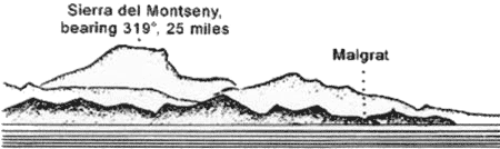 |
Sierra de Montseny from SE |
 |
Approach to Barcelona from S
Aspect |
Aspect
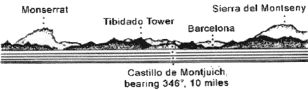
Approaching from the SW, Montana de Monserrat, with its bare conical peaks, forms an unmistakable distant landmark. This range rises 24 miles NW of the mouth of the Rio Llobregat. Pico de San Jeronimo, 1,235m high, is the highest peak and has a prominent monastery situated on its E slope.
Approaching from the E, Sierra del Montseny, standing 30 miles NNE of the mouth of the Rio Llobregat, forms a conspicuous landmark. The E rocky summit of this range attains a height of 1,707m and is covered with snow almost the whole year.
Castillo de Montjuich, situated 2.7 miles NNE of the mouth of the Rio Llobregat, stands on the summit of a hill, 207m high. The seaward side of this hill is faced with reddish cliffs. A light is shown from a structure, 13m high, standing on the SE side of the hill, close S of the castle. It is obscured N of a bearing of 240 °°.
Tibidabo, 519m high, is the highest peak of a mountain range which rises 3 miles NW of the city. A temple, with a large statue, a tall tower, and a television antennae stand on the summit of this peak. A hotel and the semi-spherical dome of an astronomical observatory are situated on its S slope.
Two conspicuous framework masts, 115m and 80m high, stand, respectively on Muelle de Barcelona and Muelle de Nuevo.
The high ground behind Castillo de Montjuich gives a good radar return, but the breakwater lights tend to get lost in the city lights, and by day are difficult to discern between the port buildings.
Pilotage
Pilotage is compulsory. Vessels should send a request for pilotage 24 hours prior to arrival.
Pilots board at the N or S entrance fairway at positions as shown on the chart.
Regulations
Vessels should contact Barcelona Traffic Coordinator on VHF channel 10 and Barcelona Pilots on VHF channel 14 one hour prior to arrival at the N or S lighted buoys. Vessels should then monitor VHF channel 10 until 2 miles from the appropriate buoy; VHF channel 14 should then be monitored for instructions.
A speed limit of 4 knots is in force within the port.
Anchorage
The roadstead is sheltered only from offshore winds and is dangerous in winter. Anchorage can be obtained by deep-draft vessels, in a depth of 40m, about 1 mile SE of the breakwater head. Small vessels may anchor closer inshore.
The East Anchorage lies to the E of the harbor, as shown on the chart. The smaller South Anchorage is to the S of the harbor, as shown on the chart.
Caution
Due to the existence of several submarine cables and a submarine gas pipeline, a prohibited anchoring and fishing area, the limits of which are shown on the chart, lies in the vicinity of the port.
Caution is necessary when approaching from the S. Vessels should keep to the E of the lighted buoy marking the coastal bank.
It is reported that extensive development is being carried out within the port. Work is in progress (2004) to extend the harbor SSW.
A bridge, with vertical clearance of 20m, connects Muelle de Levante with Muelle de Poniente
Work has commenced on two new sea walls. Additional work on a new quay is due to start within a year. The long-term plan is to double port capacity by 2011.
3.37 The Rio Besos (41°25'N, 2°14'E), lying 3.2 miles NE of the root of the breakwater at Barcelona, is frequently dry. However, when flowing during freshets, it discolors the sea in the vicinity of the mouth for a considerable distance.
A large power station is situated at the mouth of the Rio Besos and is fronted by a pier, 95m long. Torre de Besos, a tall and reddish tower, stands 1.2 miles SW of the river mouth.
It is reported (1994) that an extensive yacht harbor, protected by breakwaters, has been constructed 1.2 miles SW of Torre de Besos.
Several small jetties and a submarine pipeline, associated with a former offshore oil berth, extend seaward from the shore in the vicinity of the river mouth.
Badalona, a small town, is situated 1.5 miles NNE of the Rio Besos and is backed by hills. Vessels bound for the CAMPSA Terminal have pilot services available. The pilot may be called on VHF channel 12, 14, or 20.
Playa de Mongat extends between the NE end of Badalona and Masnou, 2.5 miles NE. A hill, 69m high, stands on this beach and is surmounted by a prominent ancient castle. Open anchorage can be obtained, in a depth of 7m, about 0.3 mile off Playa de Mongat.
Caution. – An obstruction area and fish haven, the limits of which are shown on the chart, lies 2.5 miles ENE of Badalona.
3.38 El Masnou (41°29'N, 2°19'E), a small town, is situated 2.5 mile NE of Badalona and is fronted by a yacht harbor. Turo de Mona, 175m high, stands 0.7 mile inland of the town and is prominent.
Los Colls, with depths of 6 to 9m, is a sandy bank which lies parallel to and between 0.3 mile and 0.6 mile off the coast on the NE side of the town. With offshore winds, anchorage can be obtained, in a depth of 18m, about 0.5 mile offshore in the vicinity of the town. Local knowledge is required.
Premia de Mar (41°29'N, 2°21'E), a small resort town, is situated 1.5 miles ENE of Masnou and is fronted by a small harbor. During offshore winds, open anchorage can be obtained, in depths of 7 to 10m, about 0.3 mile off the town.
San Juan de Vilasar, a village, stands 1.5 miles ENE of Premia. The coast between is fringed by a rocky bank. Anchorage, sheltered from winds between the NW and NE, can be obtained, in a depth of 7m, about 200m off San Juan de Vilasar.
Vessels should avoid anchoring off the coast between San Juan de Vilasar and the mouth of the Riera de Argentona, 1.5 miles NE.
A conical hill, 308m high, stands 2 miles N of San Juan de Vilasar and is surmounted by a prominent ruined castle. A prominent cross stands on the summit of a smaller hill standing close S of the castle. A conspicuous building, surmounted by a parabolic antenna, stands close NE of San Juan de Vilasar.
Caution. – Due to the existence of several submarine cables, a prohibited anchoring and fishing area, the limits of which are shown on the chart, extends seaward in the vicinity of San Juan de Vilasar.
3.39 Riera de Argentona (41°31'N, 2°25'E) flows into the sea 1.5 miles NE of San Juan de Vilasar. This river can be identified from seaward by the width of its valley and the gap in the hills through which it flows.
Mataro, an industrial town, is situated 1.5 miles NE of the mouth of the river. Anchorage, sheltered from SW winds by several rocky shoals, can be taken, in depths of 9 to 10m, sand, about 0.4 mile off the town. However, this roadstead is completely exposed to winds from the NE. A conspicuous building stands close SE of the town.
El Balis, a small yacht harbor, lies 3.2 miles NE of Mataro and is protected by breakwaters. El Vell, a stony bank with a depth of 16m, lies about 1.7 miles SSE of the harbor.
Caldetas (41°34'N, 2°32'E), a small town, is situated 4 miles NE of the mouth of Riera de Argentona. With offshore winds, anchorage can be obtained off this town according to draft.
Arenys de Mar, another small town, is situated 1 mile NE of Caldetas and fronted by a small craft harbor protected by breakwaters. Small vessels can anchor, in a depth of 6m, off this town. Caution should be exercised by large vessels when anchoring in the roadstead because several rocky banks, with a covering of sand, lie within 1.5 miles of the coast in this vicinity.
The town of Caldetas is backed by mountains and dominated by a hill, which is surmounted by the ruins of a tower.
The town of Canet de Mar is situated 1 mile NE of Arenys de Mar. A tall cross, visible from all directions, stands on a hill, 1.2 miles inland of the town. The village of San Pol is situated 1.7 miles ENE of Canet de Mar. It stands at the bottom of a hill which is surmounted by a prominent church. A foul area, within which fishing is prohibited, lies about 1 mile offshore between Canet de Mar and San Pol. Calella Light is shown from a tower with a dwelling, 10m high, standing 1 mile ENE of San Pol.
The town of Calella is situated 5.5 miles NE of Arenys de Mar. With winds between the NW and NNE, anchorage can be obtained, in depths of 6 to 8m, fine sand, about 0.5 mile off the beach fronting the town.
The town of Malgrat is situated 4 miles ENE of Calella. A concrete block, dangerous to navigation, lies about 0.2 mile S of the town. Temporary anchorage can be obtained, in a depth of 8m, muddy sand, about 0.4 mile off the town.
Banco de Santa Susana, despite its proximity to the coast, has been the scene of many disasters to coastal vessels. It lies about 0.5 mile offshore, 2 miles SW of Malgrat. There are general depths of 5 to 8m, sand, on this shoal bank, but because of its shifting nature, lesser depths may be found; a depth of less than 1.8m was reported at one time. The bank is very steep-to on its seaward side and the sea breaks heavily over it with fresh onshore winds. Great caution should be exercised when in this vicinity.
The Rio Tordera (41°39'N, 2°47'E) flows into the sea 1.5 miles ENE of Malgrat. It never dries and discharges a very large quantity of water after heavy rains. The sediment brought down by this river continues to extend the point located on the E side of its mouth, which should be given a wide berth.
3.40 Blanes (41°40'N, 2°48'E) (World Port Index No. 38560), a small port, lies 1.8 miles NE of the mouth of the Rio Tordera and is backed by a prominent town. The harbor is protected by a breakwater and has depths of 4.5 to 7m alongside the quays. It is reported to be no longer used by commercial shipping and accommodates only fishing craft and yachts.
A conspicuous castle surmounts a hill, 168m high, which stands close NNE of the town. A prominent convent stands on a point lying close ENE of the town.
During the summer, with winds between the W and NE, anchorage can be obtained, in depths of 13 to 15m, sand, close off the harbor or off the coast between the harbor and the mouth of the Rio Tordera. This anchorage is not safe in winter.
The town of Lloret de Mar is situated 3 miles NE of Blanes. Anchorage can be obtained, in a depth of 7m, about 0.2 mile off the town.
Cabo de Tossa (41°43'N, 2°56'E), located 3.5 miles ENE of Lloret de Mar, is the extremity of a small and steep-to peninsula which is surmounted by a castle. A light is shown from a tower on a building, 11m high, standing on the cape.
 |
Cabo de Tossa Light |
The town of Tossa is situated on the W shore of a small bay lying close N of the cape. This bay affords excellent shelter from winds between the SW and N. Vessels may anchor, in a depth of 15m, sand, close E of the SW corner of the bay and about 250m offshore.
Punta de Garbi (41°46'N, 3°02'E) is located 5.5 mile NE of Cabo de Tossa. The coast between is backed by high mountains and several small islets lie close off the shore. The point is formed by the SE extremity of a high and rugged promontory, the summit of which is surmounted by Ermita de San Telmo, a prominent chapel.
3.41 San Feliu de Guixols (41°47'N, 3°02'E), a small port, lies within a cove, 12.5 miles NE of Blanes.
Depths – Limitations. – The main facilities include North Quay, 116m long, with a depth of 3.8m alongside; East Quay, 108m long, with depths of 3 to 4m alongside; Commercial Quay, 98m in length, with depths of 6.4m alongside; and a quay, 480m long, with depths of 6 to 7m alongside, which lies on the inner side of the breakwater. Vessels of up to 120m in length and 6.8m draft have been accommodated.
It is reported (1994) that the harbor is mostly used by yachts. It is reported (2008) that the port is closed to commercial shipping.
Aspect. – This almost natural harbor lies in a cove which is entered between Punta de Garbi and Isla de Levante, 0.5 mile NE. The town is situated at the head of the cove. Isla de Levante, joined to the coast by a mole, lies at the bottom of a hill, 81m high, which is surmounted by the ruins of a mill. The harbor is protected by a breakwater which extends WSW from a point on the coast, close NW of Isla de Levante. A lighted range, situated at the head of the cove, indicates the entrance fairway.
Pilotage. – Pilotage is compulsory for vessels over 50 grt. Pilots may be contacted on VHF channel 9 and board about 0.5 mile S of the harbor entrance. Vessels arriving between midnight and 0700 must anchor outside the breakwater.
Anchorage. – Anchorage can be taken, in depths of 13 to 20m, sand, fair holding ground, outside the breakwater. Small vessels can anchor inside the harbor.
Caution. – Storms have damaged the breakwater. It should be given a wide berth to avoid any off-lying rubble.
A dangerous rock lies close E of Isla del Freu and is very close to the lighted range line. Use of the range must account for this danger.
3.42 Cala de San Pol (41°47'N, 3°03'E), a small bay, is entered 1 mile NE of San Feliu de Guixols. Small vessels, with local knowledge, can obtain anchorage, sheltered from NW and W winds, in depths of 5 to 10m, sand, within this bay.
Punta Rojiza, a low and reddish point, is located 1 mile NE of Cala de San Pol and is surmounted by two small hills. A rock, with a least depth of 5m, lies about 0.3 mile SE of this point and is almost always marked by breakers. A light is shown from a structure standing close off the point.
A depth of 1.4m lies 0.2 mile NE of Punta Rojiza. Puerto de Aro, a small yacht harbor, is situated close NE of Punta Rojiza and is protected by a pier.
3.43 Palamos (41°50'N, 3°07'E) (World Port Index No. 38580) is situated 6 miles NE of San Feliu de Guixols. The harbor lies in the NE part of a bay, which is entered between Punta de Torre Valentina, located 2.3 miles NE of Punta Rojiza, and Punta del Molino, 1.7 miles ENE.
Port of Palamos Home Page http://www.portsgeneralitat.org
Depths – Limitations. – La Llosa de Palamos, a rock with a depth of 3.4m, lies about 0.5 mile SW of Punta del Molino and is marked by a lighted beacon. A detached rocky shoal, with a depth of 1.9m, and Los Ancelles, a rocky patch with a least depth of 15m, lie close W and close SSW, respectively, of Punta del Molino.
The harbor is protected by a breakwater which extends 0.4 mile WSW from a point on the shore lying close N of Punta del Molino.
There are depths of 17 to 19m at the port entrance. The main facilities include Front Pier, 150m long, with a depth of 7.3m alongside; Old Pier, 200m long, with depths of 3 to 8m alongside; and New Pier, 220m long, with a depth of 14m alongside.
There are facilities for container, ro-ro, and fishing vessels. In addition, there is a yacht marina within the port. Vessels up to 220m in length and 13.9m draft can be accommodated.
Aspect. – Punta del Molino is the S extremity of a small peninsula on which the town stands. A light is shown from a structure, 8m high, standing on this point.
La Galera, a steep-to islet, lies close SE of Punta del Molino. Punta de Torre Valentina is surmounted by a tower.
Pilotage. – Pilotage is compulsory. Pilots can be contacted on VHF channel 12 and board about 1.5 miles outside the harbor.
Regulations. – A speed limit of 4 knots is in force within the port.
Vessels should send an ETA at least 24 hours in advance.
Anchorage. – Large vessels can anchor, in depths of 14 to 18m, within the bay. Care should be taken to leave room for vessels proceeding to and from the harbor.
Caution. – Due to scattered masonry blocks lying in the vicinity, the head of the breakwater should be given a wide berth.
Winds from SW sometimes raise a heavy sea within the harbor.
3.44 Cabo Gross (41°51'N, 3°09'E), a steep headland, is located 0.9 mile NE of Punta del Molino. A rocky patch, with a least depth of 7.6m, lies about 0.2 mile offshore, 0.4 mile SW of the cape.
Punta Castell, 36m high, is located 0.8 mile NE of Cabo Gross and is fronted by a small islet.
Las Hormigas (41°52'N, 3°11'E), lying 1 mile E of Punta Castell, is a group of rocks. La Hormiga Grande, the highest rock, is 12m high and is marked by a light.
Vessels without local knowledge should not attempt to pass inshore of this group of rocks, the Freu de Las Hormigas, and it should be given a wide berth.
Cabo de San Sebastian (41°54'N, 3°12'E) is located 7 miles NNE of Las Hormigas. It is formed by a conspicuous and reddish headland which is faced with cliffs. A light is shown from a tower with a dwelling, 12m high, standing 0.3 mile N of the S extremity of the cape.
Llanfranch, a small yacht harbor, lies at the head of a cove, close SW of the cape. Los Ullastres, consisting of three rocky shoals, lies about 0.5 mile S of the cape and has a least depth of 7.1m.
Punta del Banch is located 2 miles N of the Cabo de San Sebastian. A small yacht harbor and a prominent hotel are situated 0.7 mile N of this point.
3.45 Cabo de Bagur (41°57'N, 3°14'E) is located 4 miles NNE of Cabo de San Sebastian. It is surmounted by a prominent one-story signal station.
Cala de la Tuna, a small bay, lies 1 mile N of Cabo de Bagur and affords shelter to small vessels from winds between E and S. Vessels with local knowledge may anchor, in depths of 16 to 18m, within the bay.
The Rio Daro and the Rio Ter flow into the sea 3 miles and 4 miles NNW, respectively, of Cala de la Tuna. A beach extends along the shore between the N entrance point of Cala de la Tuna and the mouth of the Rio Ter. A shoal bank fronts the beach and extends for some distance offshore. Due to the shifting nature of the bottom, and drying patches along the extent of Playa de Pals caused by the river flooding, along with numerous fish havens, a minimum distance of 0.8 mile should be given this stretch of coast.
Punta Guixeras (42°03'N, 3°13'E), the SE extremity of a promontory, is located 2 miles NNE of the mouth of the Rio Ter. A Loran tower, 297m high, stands 0.5 mile NW of this point and is conspicuous.
Estartit, an extensive yacht harbor, lies close W of the point and is protected by breakwaters.
Islas Medas, formed by a group of rocky islets, lies 0.5 mile SE of Punta Guixeras. The channel leading between this group and the coast is deep, but local knowledge is required by even small craft in order to use the passages lying between the islets themselves.
Isla Meda Grande is the largest and NW islet of the group. A light is shown from a structure, 11 high, standing on its summit.
Caution. – A marine reserve area surrounds Islas Medas and extends to Punta Guixeras. Fishing and anchoring within this area are prohibited.
3.46 Golfo de Rosas (42°11'N, 3°11'E) lies between Punta Trenca Brasos, located 3.5 miles NNW of Punta Guixeras, and Cabo Noffeo, 9 miles NE. Cala de Mongo and Cala de la Clota, the principal coves along this stretch of coast, are entered close S and 1.5 miles WNW, respectively, of Punta Trenca Brasos. They are both exposed to NE winds and are only available to small vessels with local knowledge.
A wharf, used by fishing vessels, is situated on the E side of Cala de la Clota, and an extensive yacht harbor lies in the vicinity of this cove.
The Rio Muga flows into the NW part of Golfo de Rosas, 8 miles NNW of Punta Trenca Brasos. The village of Castellon de Ampurias stands on the N bank of this river, 2.5 miles inland. It is situated on a hill, 69m high, and is conspicuous from seaward.
3.47 Rosas (42°16'N, 3°11'E) (World Port Index No. 38705), a small port, lies within a bay in the NE part of Golfo de Rosas close to the French border.
Depths – Limitations. – The main facilities include Commercial Quay, 304m long, with depths of 3.5 to 4.5m alongside; Extension Quay, 300m long, with depths of 4 to 4.5m alongside; and Breakwater Quay which has 320m of usable berthing space with depths of 7 to 10m alongside. Vessels up to 40m in length and 4m draft can be accommodated.
In addition, a yacht harbor is situated in the vicinity of the town.
Aspect. – The town is situated at the head of the bay. The prominent ruins of a citadel stand close NW of the town, and several conspicuous large hotels stand in this vicinity.
A light is shown from a tower on a dwelling, 11m high, standing on a point, 1.2 miles SSE of the citadel.
Pilotage. – Pilotage is available from Palamos. The harbor can be contacted by VHF.
Anchorage. – Large vessels can anchor in the bay. The most convenient berth, in depths of 14 to 17m, mud and sand, lies 0.5 mile offshore, S of the citadel.
Caution. – The anchorage is encumbered by a marine farm, marked by lighted buoys and a submarine pipeline, marked by a lighted buoy, to the W and NW of the area.
3.48 Cabo Norfeo (42°14'N, 3°16'E) is high, steep-sided, and is surmounted by the ruins of a water tower. A high islet lies off the SE extremity of this cape.
Punta de Cala Nans is located 2 miles NNE of Cabo Norfeo. A light is shown from a structure, 7m high, standing on the point. A patch, with a depth of 1.6m, lies about 0.6 mile NNE of the light.
Cadaques (42°17'N, 3°17'E), a resort town, is situated at the head of a bay which is entered between Punta de Cala Nans and Isla Arenella, 0.6 mile NNE. The latter island lies close off the promontory which forms the E side of the bay.
The town is fronted by a very small natural harbor with an anchorage area for large and small vessels.
The bay can be identified by Montana de Cadaques, 610m high, which stands 1.5 miles W of the town. Its summit is surmounted by the cupola of a radar installation.
San Sebastian Hermitage is situated 0.7 mile ESE of Montana de Cadaques, and the old Convent of San Pedro de Roda stands on the summit of a mountain, 4.2 miles WNW of Montana de Cadaques.
Casa Colom, a prominent building with two towers, stands on a hill at the NE side of the bay, 0.3 mile SE of the town.
Vessels of deep draft can obtain anchorage, in depths of 10 to 20m, SE of the center of the town. Small vessels can anchor, in a depth of 7m, farther inshore off the NE end of the town.
Caution. – A shoal bank extends 95m seaward from the beach which fronts the town. Bajo de La Entina, a shoal with a depth of 2.7m, lies about 0.3 mile S of the town, off the SW side of the bay.
Several dangers lie in the approach to the bay; local knowledge is required.
3.49 Punta Oliguera (42°17'N, 3°18'E), low and rocky, is located 0.3 mile NE of Isla Arenella. Las Masinas, a group of dangers, lie 0.7 mile NE of this point. The group consists of one islet and several above-water rocks.
Cala Guillola, entered 1.2 miles NNW of Punta Oliguera, is open to the SE. This cove affords shelter from N winds, and vessels can anchor, in a depth of 14m, sand and weed.
Cabo Creus (42°19'N, 3°19'E), located 2.3 miles NNE of Punta Oliguera, is formed by the SE extremity of a small and dark peninsula. A light is shown from a tower surmounting a dwelling, 11m high, standing on the summit of the cape.
Dedos de Cadaques, two conical peaks, rise 2 miles W of this cape and are prominent.
Islote La Encalladora, fringed by a reef on its SW side, lies close off the NE side of Cabo Creus. Isleta Maza, another rugged islet, lies 0.5 mile E of Cabo Creus.
Punta dels Farallons, fronted by several small islets, is located 2.5 miles WNW of Cabo Creus and terminates in a white cone. The coast between is indented with several coves and is fronted by numerous small islets, rocks, and shoals.
El Golfet, a cove, lying close W of Punta dels Farallons, affords anchorage, sheltered from winds from the E through S to W. However, it is exposed to N winds, which blow during the winter and becomes dangerous.
Punta de la Creu is located 2.5 miles WNW of Punta dels Farallons and fronted by a small islet. A hill, 119m high, rises close inland of the point.
3.50 Punta Sernella (42°21'N, 3°11'E), a steep point, is located 0.7 mile WNW of Punta de la Creu. A rock, with a depth of 2.7m, lies close off this point. A light is shown from a square tower standing on the point.
The town of Selva stands on the E side of the bay, which lies between Punta de la Creu and Punta Sernella. It is fronted by a small harbor which is used by yachts and fishing craft.
There is good anchorage for large vessels in this bay, but winter winds from the N and NW may make the anchorage untenable. The best berth, in depths of 10 to 15m, muddy sand, lies in front of the town.
Ensenada de Llansa, a small bay, is entered 2 miles NW of Punta Sernella. It is not sheltered against winds from the NE and is only frequented by small vessels.
Cap Ras is located 2.5 miles NNW of Punta Sernella and is fronted by two islets. Cala Garvet lies between Cap Ras and Cap Lladro, 0.7 mile N. With offshore winds, this bay affords good anchorage, in a depth of 11m, to vessels with local knowledge.
Cap Lladro is formed by a whitish headland and fronted by an islet and a conical rock, both of which are of a whitish color. Cala Culera, entered close N of Cap Lladro, is a deep cove with good holding ground, but it is exposed to onshore winds and violent squalls that sweep down from the mountain slopes. A small harbor, protected by breakwaters, is situated at the head of this cove.
The whole coast between Cap Lladro and Cap Cerbere is high, rugged, and steep-to. The currents off the coast are often influenced by the prevailing wind.
Punta Gatillepis is located 0.5 mile N of the N entrance point of Cala Culera. The coast between is very steep and rises to a height of 198m.
Port Bou lies at the head of a cove which is entered on the N side of Punta Gatillepis. It is exposed to E winds, and although sheltered from N winds, is subject to heavy seas and ground swell. This cove is not considered a good shelter, except in cases of necessity.
The boundary between Spain and France lies in the vicinity of Cabo Falco, which is located 1 mile NE of Port Bou.
Cap Cerbere (42°26'N, 3°11'E) is located 1.2 miles N of Cabo Falco and is described in paragraph 9.2.