MOROCCO – PUNTA ALMINA TO OUED KISS SECTOR 5
Plan. – This sector describes the coast of Morocco from Punta Almina (35°54'N, 5°17'W) to the frontier of Algeria at Oued Kiss (35°05'N, 2°12'W). The descriptive sequence of the coast is from W to E.
General Remarks
5.1 Winds – Weather. – The prevailing winds along this part of the coast are from the NE quadrant from March to October, and from the SW and NW quadrants during the remainder of the year.
During summer, there are often E winds on the Moroccan coast when there are W winds on the Spanish coast. Winds from the E are often preceded by increased humidity, haze, and mist.
Calms are also frequent in summer along the E part of this coast.
Gales from the NW and NE quadrants are often severe, but are less frequent on this coast than in the N part of the Mediterranean Sea. Gales from the S are almost unknown.
Tides – Currents. – The offshore current generally sets SE from the Strait of Gibraltar. Off Cap des Trois Fourches, this current divides and part of it continues E. The other part is deflected by the cape and causes a counter current which sets W along the coast of Morocco at a rate of about 1 knot. These currents are also influenced by the prevailing winds.
A current sets W off Cabo Baba and sometimes attains a rate of 2 knots.
Caution. – With the exception of the stretches of coast lying between Punta Almina and Cabo Mazari, 21 miles S, and that between Cap des Trois Fourches (35°26'N, 2°58'W) and the mouth of Oued Moulouya (Rio Muluya), 43 miles SE, the coast of Morocco is practically unsurveyed. Vessels are cautioned not to approach it without special precautions.
Tunny nets may be found extending up to 7 miles offshore along the coasts described in this sector. Submarines exercise frequently in the waters adjacent to the coasts.
Off-lying Islands
5.2 Islas Chafarinas (35°11'N, 2°26'W), consisting of three islands, lie 2 miles N of Cap de l’Eau (Ras el Ma). They are of volcanic origin and consist of white decomposed rock. When seen from the E or W, these islands show up well, but from the N, they are difficult to distinguish from the land behind them.
Isla del Congreso, the largest and W island, is steep and rugged on its W side, which is 137m high, but has more of a gentle slope on its E side. A light is shown from a tower, 3m high, standing on Punta del Faro, the S extremity.
Isla de Isabel II, the middle island, lies close E of Isla Congreso. It is 40m high and Torre de la Conquista, which is fitted with a conspicuous clock, stands near the middle of the N side.
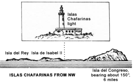 |
Islas Chafarinas from NW |
Numerous large buildings, including a hospital, are situated on the island. Islas Chafarinas Light is shown from a structure, 18m high, standing near the NW extremity of this island.
Isla del Rey, the E island of the group, is 31m high. It is connected to Isla de Isabel II by a partly-destroyed breakwater.
These islands afford the only natural anchorage roadstead off the coast of Morocco which is suitable for all classes of vessels. There are depths of 10 to 17m; good holding ground, muddy sand.
In winter, strong winds from the S sometimes blow. With strong E winds, a considerable swell often rolls into the anchorage. Strong winds from the NE also send a considerable sea into the anchorage through the channel lying between the two W islands, despite the shoal in its approach.
The best berth, sheltered from NE winds, is in a depth of 14m, about 230m SE of the head of the small mole, which extends near the S end of Isla de Isabel II.
Punta Almina to Baie d’al Hoceima
5.3 Punta Almina (35°54'N, 5°17'W) is the E extremity of the peninsula which divides Bahia de Ceuta, to the N, from Ensenada de Ceuta, to the S. The point is low but the land rises steeply behind it. A light is shown from a structure, 16m high, standing on Cerro de Mosqueros, close SW of the point.
A shoal, Laja de la Sirena, with a depth of 4.1m, lies close NE of the point.
Ensenada de Ceuta (35°51'N, 5°19'W) lies between Punta Almina and Rasel el Aswad, 13 miles S. A light is shown from the point. Open anchorage can be obtained, in depths of 20 to 26m, anywhere off the coast within this extensive bay, but care should be taken to ascertain the nature of the bottom as it is rocky in places. Tunny nets may be encountered in the bay from June to October.
 |
View of the coast S of Peninsula de Almina |
Ensenada de la Almadraba, a small bay, lies 2 miles WSW of Punta Almina. It affords anchorage, sheltered from N and W winds, in depths of 15m or more. An obstruction lies 0.5 mile offshore in the E approach to this bay.
Punta del Canto (Pointe es Sensela), located 4.5 miles SW of Punta Almina, is a low, reddish, and rocky point. A factory, with several conspicuous chimneys, is situated on the S side of this point. With winds from the SW to NW, if not too strong, anchorage can be obtained, in depths of 16 to 20m, sand, about 1 mile SE of Punta del Canto.
La Condesa, 15m high, stands on the coast, 1 mile S of Punta del Canto. This hillock is surmounted by the white buildings of a military post. The conspicuous buildings of a large barracks, which are usually brilliantly illuminated at night, are situated on a hill, 0.5 mile S of La Condesa.
Piedra Blanca lies 0.3 mile offshore, about 2.3 miles S of Punta del Canto. It has a least depth of 2.1m and is easily distinguished in calm weather by the light green color of the water over it.
Punta Restinga, located 5.8 miles S of Punta del Canto, is a small projection, 15m high. A tourist resort, which includes several hotels and numerous single-story buildings, extends up to 1 mile S from the point and is conspicuous from seaward.
Jebel Zem-Zem (Monte Sem-Sem), 435m high, stands 2 miles SW of Punta Restinga. Fortin Negron, a fort in ruins, is situated on its N foothills. Good anchorage can be obtained, in a depth of 31m, sand and gravel, about 2.3 miles NE of Fortin Negron.
5.4 M’diq (Rincon El Medik) (35°41'N, 5°19'W), a village, is dominated by a high, reddish, and prominent church. An Arab cemetery is situated on the slope of the hill, close S of the village. A small harbor, protected by moles, lies 0.5 mile E of the village and is used by small coastal vessels and yachts. There is a main quay, 240m long, with a depth of 5m alongside. Vessels up to 50m in length and 4.8m draft can be accommodated.
Anchorage, sheltered from S and SSE winds, but exposed to those from the N, can be obtained, in depths of 10 to 22m, sand, about 0.5 mile off the coast near M’diq.
Rasel el Aswad (Cabo Negro) (35°41'N, 5°16'W), located 2.5 miles E of M’diq, is faced with cliffs. It is surmounted by a hill, 119m high, on which stands a conspicuous tower surrounded by shrubs. The cape is dominated by Monte Taifor, a dark-colored and conical hill, which stands 1.3 miles WSW of it and rises to a height of 331m. A light is shown from a tower, 13m high, standing on the cape.
Off the cape, the tidal currents are sometimes strong and eddies are always formed within 1 mile of it.
Vessels can anchor, in a depth of 35m, sand and gravel, about 2.8 miles NW of the tower standing on Rasel el Aswad. Vessels can also anchor, in a depth of 22m, sand and shells, about 2.5 miles E of a conspicuous hill which stands 4 miles WNW of Rasel el Aswad. This hill is 130m high, reddish -colored, and surmounted by a grove of trees.
Ensenada de Tamerabel (Ensenada de Tetouan) lies between Rasel el Aswad and Cabo Timurusga, 9.5 miles SSE. It affords anchorage, sheltered from winds between the SE and NW, but care should be taken to select a sandy spot, as the bottom is rocky in places.
The Oued Martin flows into the sea 4 miles S of Rasel el Aswad, and the small town of Martil (Oued Martin) is situated close N of the mouth. A light is shown from a structure, 16m high, standing in the town. Vessels can anchor, in depths of 14 to 18m, sand, about 1 mile E the light. Vessels should exercise caution as submarine cables lie in this vicinity.
The port of Al Martil (Oued Martin) no longer exists due to silting.
Tetouan, a town, is situated 6 miles WSW of the mouth of Oued Martin. It stands at an elevation of 61m and the buildings and tall minarets are visible from seaward. An aeronautical light is reported to be occasionally shown from close ENE of the town.
5.5 Cap Mazari (35°33'N, 5°13'W) is located 4.5 miles SSE of the mouth of Oued Martin. Ensenada de Mazari lies between this cape and Punta de la Caverna, 1.3 miles ESE. Anchorage can be obtained, in depths of 13 to 15m, sand, within this bay, but onshore winds raise a heavy sea.
Cap Menkal (Pointe Omara) (35°29'N, 5°06'W), located 15 miles SE of Rasel el Aswad (Cabo Negro), is steep, fronted by an islet, and surmounted by a circular tower. A white marabout and several other white buildings, which show up well against the green background, are situated close S of the cape.
Oued Laou Light is shown from a tower standing near the cape.
In good weather, open anchorage can be obtained, by vessels with local knowledge, off the beach which extends S of the cape. Caution should be exercised in order to avoid several submarine cables which are landed in this vicinity.
This part of the coast is backed by mountains which stand SW of Cap Menkal and attain elevations of over 2,000m. Jebel Kelti, 1,926m high, stands 11 miles SW of the cape. This mountain can easily be identified by its isolation and its flattened, dark grey, barren, and rocky summit. During E winds, it is frequently obscured by clouds.
Punta Targa, located 6.2 miles SE of Cap Menkal, is surmounted by a prominent tower. Several rocks, one of which is conspicuous, lie close off this point.
Banco Cotelle, is reported to lie about 1.5 miles E of Punta Targa, and to have a depth of about 1.5m, with depths of from 6.4 to 8.2m between it and the coast. The sea does not appear to break on it, but tide rips have been reported in the vicinity. This danger has not been examined, and this part of the coast should be given a berth of at least 2 to 3 miles.
Punta Jagershmidt, located 9.5 miles SE of Punta Targa, is dark, rounded, and is fronted by two conspicuous, rocky islets.
Ensenada de Tiguizas, a slight indentation in the coast, lies close NW of Punta Jagerschmidt. In good weather, open anchorage can be obtained by vessels with local knowledge within this indentation. The best berth is in a depth of 40m, sand, about 1 mile offshore.
Pointe de Pecheurs (Punta Pescadores) (35°13'N, 4°39'W), located 11.5 miles SE of Punta Jagershmidt, is rocky and has the appearance of an island when seen from the E or W. This point is one of the most conspicuous landmarks along the coast. It is salient and is faced with dark cliffs which are marked by reddish patches. A prominent rock, which resembles a tower, stands on its summit. A light is shown from a structure, 4m high, standing on this point.
Ensenada des Pecheurs lies on the W side of the point and in good weather, anchorage, sheltered from winds between the SE and WSW, can be obtained within this bay. Vessels with local knowledge can anchor, in a depth of 13m, mud, but fresh breezes send in a heavy swell.
Monte Scovasso, 1,190m high, stands 6 miles SW of Pointe de Pecheurs and has a prominent notch on its summit.
5.6 Isle Iris (35°10'N, 4°22'W), located about 15 miles ESE of Pointe de Pecheurs, is 38m high and barren. White vertical cliffs stand on its NW side, but the island is not easily distinguished from the land behind it. The island is joined to the mainland by a reef which has depths of less than 1.8m.
Ensenada de Iris, a cove, lies close W of Isle Iris. In good and settled weather, small vessels with local knowledge can obtain anchorage, in depths of 6 to 11m, fine sand, in this cove. Small vessels with local knowledge can also obtain anchorage sheltered from W winds, close E of Isle Iris.
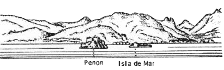
Penon de Velez de la Gomera (35°10'N, 4°18'W), located 18 miles ESE of Pointe de Pecheurs, is a conical and rocky island. Its N end is 86m high and is surmounted by a conspicuous fortress. The island is connected by a rocky ridge to an islet, 21m high. It is easily identified from the W to N, but when approaching from the E, it is partially hidden by the land. A light is shown from a structure, 6m high, standing on the NW extremity of the island.
Cap Baba (35°12'N, 4°17'W), located 0.8 mile ENE of Penon de Velez de la Gomera, is formed by a bold and dark headland. It is steep and surmounted by the ruins of a marabout tower. The cape descends from a spur of the mountains, in the crest of which is a break, which appears as a hole when seen from the E.
A current, which sets in a W direction and sometimes attains a rate of 2 knots, has been frequently experienced off this cape.
In good weather, temporary anchorage can be obtained by vessels of moderate size, between Penon de Velez de la Gomera and Cap Baba, but local knowledge is necessary. Caution should be exercised to avoid the submarine cables which are landed in the vicinity of Penon de Velez de la Gomera.
Pointe Khalou (Punta Jalu), located 5 miles ENE of Cap Baba, is high, rocky, and almost vertical. An islet lies close off this point.
Pointe Boussikour (Punta Busicur), located 8.5 miles ENE of Pointe Khalou, rises to a conical mountain which is surmounted by a conspicuous building.
5.7 Punta de los Frailes (35°16'N, 3°56'W), located 4.5 miles ENE of Pointe Boussikour, is fringed by a reef. Morro Nuevo Light is shown from a structure, 16m high, standing on this point.
Punta Morro Nuevo (Ras Tarf) (35°15'N, 3°55'W), located 1 mile SE of Punta de los Frailes, is a high and prominent headland. It is formed of inaccessible white and yellow cliffs on which there are patches of iron rock, rusty in color.
Baie d’al Hoceima (35°14'N, 3°52'W) lies between Punta Morro Nuevo and Ras Sidi Chaib, 8 miles ENE. This bay has mountainous land both E and W of it, but is low at its head.
Penon de Alhucemas lies about 0.3 mile offshore, 3 miles SSE of Punta Morro Nuevo. This islet is 27m high at its N end and is mostly covered with buildings and fortifications. Islote de Mar and Islote de Tierra, two low and rugged islets, lie 0.5 mile WNW of Penon de Alhucemas.
An aeronautical radiobeacon is reported (1993) to be situated inland, 0.9 mile S of the head of the bay.
 |
Baie d’al Hoceima – Penon de Alhucemas bearing 228° |
5.8 Al Hoceima (35°15'N, 3°55'W) (World Port Index No. 45720), a small port, lies on the W side of Baie d’al Hoceima, 0.5 mile SW of Cabo Morro Nuevo (Ras Tarf). It was formerly known as Puerto de Villa Sanjurjo.
Winds – Weather. – Offshore winds are infrequent. Severe NE gales may be expected during the winter. In the past, such storms have caused much damage to the harbor and the shipping in it.
Tides – Currents. – Tides rise about 0.6m at springs and 0.5m at neaps.
The currents in the bay are irregular and are influenced by the prevailing wind. At times, they may attain a rate of 1 knot. Eddies and tide rips are reported to be experienced off both the entrance points of the bay.
Depths – Limitations. – The harbor is protected by two breakwaters and is subject to silting. There are depths of 13 to 20m in the entrance, but generally less than 6m within the harbor. The NW part of the harbor is mostly used by fishing vessels. A quay, situated at the root of the E breakwater, has depths of 5.8 to 8m alongside and is mostly used by naval vessels. Two wharves, each 75m long, are situated on the inner side of the E breakwater. Vessels up to 105m in length can be accommodated within the harbor, but those with drafts of more than 4.8m should exercise great care.
Aspect. – Monte de Malmusi, 330m high, stands 2 miles SW of Cabo Morro Nuevo. At its summit there is a prominent notch which is visible on most bearings, though to a lesser degree on S ones, when a similar notch in a lower hill in front of it may lead to error.
Lighted ranges indicate the approach and entrance channels and may best be seen on the chart. At times, they are reported to be difficult to distinguish.
Pilotage. – Pilotage is compulsory. Pilots can be contacted on VHF channel 16 and board about 0.3 mile SE of the entrance at the junction of the approach and entrance leading lines.
Anchorage. – Baie d’al Hoceima, though open to the N, affords anchorage to vessels with local knowledge. In good weather, vessels can anchor, in a depth of 11m, good holding ground, about 0.2 mile E of Penon de Alhucemas. During NE winds, anchorage can be obtained, in a depth of 12m, in the SE corner of Baie d’al Hoceima. During E winds, anchorage can be obtained, in depths of 10 to 20m, on the E side of Baie d’al Hoceima.
Caution. – The bottom of Baie d’al Hoceima is mostly sand, with some gravel and mud, but as it is rocky in places, the nature of the ground should be determined before anchoring; generally, the greater the depths, the firmer the bottom.
5.9 Cabo Quilates (Jebel Quilates) (35°17'N, 3°41'W), located 3.5 miles ENE of Ras Sidi Chaib, is formed by the NW extremity of a low and rounded promontory. It descends in gentle slopes from a range, 443m high, which stands on the E side of Baie d’al Hoceima.
A light is shown from a three-story tower, 32m high, standing on this cape.
Ras Tasemsalt, located 3.5 miles SE of Cabo Quilates, can be identified by its cliffs which rise steeply from the sea and are fronted by several black rocks. A yellow patch, which indicates the mouth of a deep cavern, is located at the foot of these cliffs.
Sidi Dris, a conspicuous and isolated white shrine, stands on the summit of a coastal hill, SE of Ras Tasemsalt.
Pointe Afraou (Punta Afrau) (35°12'N, 3°27'W), located 12.3 miles ESE of Cabo Quilates, is moderately high and fringed by a shoal bank. It is formed by the cliffy termination of a spur of the mountains which extend to within a few miles of the coast.
A loading berth for ore, with several mooring buoys, lies on the W side of the point. A large house, the only one in this vicinity, stands 2 miles W of the berth. When a vessel is expected, a light is shown from this house until 2200. There is reported to be a depth of 7m at the mooring berth ; vessels exceeding 107m in length and 6.4m draft should not load here.
Vessels can anchor, in a depth of 16m, sand and gravel, about 1.8 mile NE of the house.
Monte Barcaiztegui (35°09'N, 3°26'W), 924m high, stands 3.7 miles SSE of Pointe Afraou. It is the most conspicuous of all the mountains along this part of the coast.
Punta Betoya, located 11.7 miles E of Pointe Afraou, ends in low cliffs. A hill standing above the point is surmounted by a white shrine surrounded by dark-colored buildings.
Ensenada de Azanen lies between Punta Betoya and Punta Garet, 4.5 miles NE. This bay is open W through N to NE, but with offshore winds, it affords anchorage, in depths of 14 to 17m, mostly sand. Local knowledge is advised. Punta Garet is fronted by shoals which extend up to 2.5 miles NE.
Punta Negri, located 1 mile NNE of Punta Garet, is easily identified because it is higher than the land in its vicinity. This point is faced with black vertical cliffs, and because of its straight and uniform appearance, it seems artificial.
5.10 Cala Tramontana (35°24'N, 3°00'W), a cove, lies 9.2 miles NE of Punta Negri. It has an entrance 0.3 mile wide and can be only entered by small vessels with local knowledge. Conspicuous conical hills stand on both entrance points of this cove and a conspicuous sandhill stands on its S side.
Islote Charranes, a conspicuous rock, lies 0.2 mile S of the S entrance point of Cala Tramontana. In good weather or with E winds, good anchorage can be obtained, in depths of 18 to 20m, SW of this rock. Local knowledge is advised.
Ras Baraket, marked by a light, is the N entrance point of Cala Tramontana.
Cap des Trois Fourches (Ras Tleta Madari) (35°26'N, 2°58'W) is located 3.2 miles NE of Ras Baraket. It is formed by the N extremity of a very conspicuous and salient promontory which terminates in several points, four of which are more pronounced than the others.
All the points are dominated by high land and the N side of the promontory presents a volcanic appearance.
Off this promontory, a heavy sea is often raised by E winds and it should be given a wide berth.
Cabo Tacsafet is the westernmost and most salient of the principal points. It is fronted by a black conical rock and a shoal, with depths of less than 1.8m, lies about 0.3 mile ENE of it.
Punta del Tio Pinar is located 1 mile ENE of Cabo Tacsafet. A shoal, with a depth of 0.3m, lies about 0.3 mile NW of it.
Punta de Cabo Nuevo is located 0.7 mile E of Punta del Tio Pinar. A light is shown from a structure, 18m high, standing on this point.
Punta Calaveo is located 0.3 mile ESE of Punta de Cabo Neuvo and separated from it by a deep gorge. From the N, this point, which is the fourth principal one, appears conical.
Punta de los Farallones, located 0.8 mile SSE of Punta Calaveo, is fronted by a small islet which shows up well from the N or S.
Los Farallones, consisting of three low islets, lies 0.5 mile E of Punta de los Farallones. Farallon Grande is the N and largest of the islets. A light is shown from a structure, 5m high, standing on this islet. Laja Lipiana, which is awash and usually marked by breakers, lies close NNE of Farallon Grande.
The channel lying between this group and the coast has depths of 10 to 14m and is used by local vessels. It should not be attempted without local knowledge.
World Port Index No. 45710
5.11 The port of Melilla lies on the E side of the Cape des Trois Fourches promontory, 8 miles S of Los Farallones. The city is the largest in the E part of Morocco and is Spanish territory. Its importance is largely due to the very large deposits of iron ore which are located about 15 miles inland.
Port of Melilla Home Page http://www.puertomelilla.com
Winds – Weather. – The strongest winds experienced in the port of Melilla are from the NE and E. Gales from these directions occur most frequently in winter. Westerly winds are at times strong and of long duration, but they do not raise a heavy sea. When the W side of Monte Gurugu is covered with light misty clouds, a Levanter, which will later reach the roadstead at Melilla, has already started to blow, if however, clouds hang over the E side of the mountain, W winds may be expected.
Tides – Currents. – Tides rise about 0.6m at springs and 0.4m at neaps. The current off the harbor entrance is weak and usually sets to the S.
Depths – Limitations. – The harbor is protected from the N by Dique del Nordeste, a breakwater, which extends about 600m E and then 350m SSE. Dique Sur, another breakwater, protects the harbor from the S. It extends about 0.4 mile NE from a point on the coast, 1 mile SSW of the head of Dique del Nordeste.
There are quays on the inner side of the N breakwater, with depths of 7.1 to 11.5m alongside. Muelle de Ribera extends W of the breakwater and has depths of 5.0 to 7.6m alongside. Muelle Espignon has three berths with alongside depths of 6.1 to 10.2m. A basin, used by fishing boats, lies in the NW part of the harbor.
Vessels up to 12,200 tons, 200m in length, and 8.0m draft can be accommodated.
Aspect. – Melilla, a fortified town, is easily identified by its many prominent buildings. It partly stands on a small, rocky peninsula which is connected to the mainland by a narrow isthmus, 29m high. The greater part of the town stands on the mainland and extends S along the W side of the port.
Monte Gurugu, 885m high, stands 6 miles SSW of the city. It has several peaks and slopes gently to the sea. When seen from the NNE, two of these peaks form a conspicuous saddle. A hill stands at the foot of this mountain and is surmounted by a white marabout, with a small woodland lying on one side of it.
A mining center, situated S of Monte Gurugu, is marked by smoke during the day and by lights at night. Sebkha Bou Arg, an extensive lagoon, extends 13 miles SE from the S part of the town. It is separated from the sea by a sandy beach which is backed by a narrow strip of land covered with low dunes.
Monte Atalayon, a conical and prominent hill, stands on the W side of Sebkha Bou Arg, 5 miles SSE of the port. It is joined to the W shore of the lagoon by a small sandy isthmus. An aeronautical light is occasionally shown from a structure standing 3.7 miles S of this hill.
A light is shown from a structure, 12m high, standing close N of the root of the N breakwater.
Regulations. – Vessels should send their ETA 72 hours, 48 hours, and 24 hours prior to arrival, stating:
- Vessel name, call sign, and nationality.
- Vessel’s grt, nrt, and loa.
- Draft on arrival.
- Last cargo and if any dangerous cargo on board.
Pilotage. – Pilotage is compulsory for vessels of more than 50 tons. The pilot requires 1 hour advance notice and boards near the harbor entrance.
Vessels should contact Port Control prior to arrival on VHF channel 11, 12, 14, or 16.
Anchorage. – Large vessels can anchor, in depths of 25 to 40m, mud and sand, good holding ground, in a rectangular area centered 0.8 mile E of the harbor entrance, but this roadstead is exposed to NE and E winds.
Vessels carrying dangerous goods may anchor in a circular area centered 1.2 miles NE of the head of the N breakwater. Caution. – The harbor is subject to silting and requires continuous dredging. Several submarine cables extend from a point on the shore close N of the harbor and may best be seen on the chart. Vessels should not anchor within 0.5 mile of the head of Dique del Nordeste, due to debris from a cleared wreck.
Port Nador (Beni-Enzar) (35°17'N, 2°56'W)
World Port Index No. 45762
5.12 Port Nador adjoins the port of Melilla and is Moroccan. The town of Nador is situated 13 miles SW of the port.
Depths – Limitations. – The harbor is protected from the N by Dique Sur, which forms the S part of the port of Melilla. The SE part of the harbor is formed by Dique Principale which extends about 0.7 mile NE and then 0.5 mile NNW. The port is approached through the same entrance, 625m wide, which is used for Melilla. The entrance channel has been dredged to a depth of 13.5m.
The main facilities include Quay No. 2, 303m long, with a depth of 6.3m alongside; Quay No. 3, 307m long, with a depth 8.3m alongside; Quay No. 4, 600m long, with a depth of 8.3m alongside; and Quay No. 5, 400m long, with a depth of 9.5m alongside.
There are facilities for fishing, tanker, ro-ro, reefer, and bulk vessels. Vessels up to 60,000 dwt and 10.7m draft can be accommodated. Pilotage. – Pilotage is compulsory for vessels over 50 tons. Pilots can be contacted on VHF channel 16 and board about 0.5 mile NE of Dique Principale. Vessels should send their ETA 72 hours, 48 hours, and 24 hours prior to arrival. The pilot should be contacted when within VHF range and at least 1 hour prior to arrival.
Caution. – A lighted wave recorder buoy is moored 3 miles ESE of the harbor entrance.
5.13 Restinga de Tofino (35°09'N, 2°47'W), a large and prominent black rock, is located 11 miles SE of Melilla. It lies on a beach and is surrounded by several smaller rocks.
Azrou Ourhioul (Punta Quiviana), located 15 miles SE of Melilla, is a rocky point and of no great elevation. It is fronted by several islets, one of which is high and conical.
Cap de l’Eau (Ras el Ma) (35°09'N, 2°25'W), 40m high, is located 26 miles ESE of Melilla. It is formed by a flat headland and marked by several buildings and fortifications. A light is shown from a structure, 8m high, standing on the cape.
Ras Kebdana, a small harbor on the E side of the cape protected by breakwaters, is used by fishing vessels and yachts.
Islas Chafarinas, which have been previously described in paragraph 5.2, lie 2 miles N of the cape.
A prominent radar tower stands about 6.7 miles SE of the cape.
Oued Moulouya flows into the sea 4.5 miles ESE of the cape and is one of the largest rivers in Morocco.
Saidia (35°05'N, 2°13'W), a village, is situated 10.5 miles ESE of Cap de l’Eau. It is marked by two conspicuous towers, one of which stands at a bathing resort, nearly 1 mile W of the mouth of Oued Kiss (Oued Skiss). This river forms the boundary between Morocco and Algeria.