ALGERIA AND TUNISIA – CAP MATIFOU TO CAP SERRAT SECTOR 7
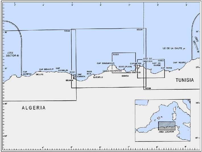
Plan. – This sector describes the Mediterranean coasts of Algeria and Tunisia, between Cap Matifou (Bourdj el Bairi) (36°49'N, 3°14'E) and Cap Serrat (37°14'N, 9°13'E). The descriptive sequence is from W to E.
General Remarks
7.1 Tides – Currents. – Strong currents are experienced in the vicinity of Banc de Matifou. Currents in the N approach to Golfe de Bejaia are strong at times and generally set towards the gulf.
A strong current sets N along the coast to the W of Cap Bougaroun (Cap Bougaroni) (37°05'N, 6°28'E), and gives rise to a confused sea when the wind is from the N. At the cape, winds from the W strongly predominate in winter (October to May) throughout the day. From June to September, winds from the E predominate.
In winter, strong currents are experienced in the vicinity of Cap de Fer (37°05'N, 7°10'E). With WNW winds, a heavy swell is in evidence.
Along the N coast of Tunisia, the currents are very variable and are mainly due to the winds. Offshore, the prevailing W and E winds give rise to fairly strong currents. A W current, with a rate of 2 to 3 knots, has been experienced in the vicinity of Ecueils des Sorelles and Jazirat Jalitah.
Caution. – The People’s Democratic Republic of Algeria has temporarily suspended permission to navigate within Algerian territorial waters up to 10 miles offshore, between meridians 3°15'E and 4°10'E
Vessels wishing to enter or depart the following ports should adhere to the designated channels, as follows: 1. Port de Zemmouri – Vessels should keep to the channel oriented N-S between 3°33.5'E and 3°34.6'E
- Port de Dellys – Vessels should keep to the channel centered on the port’s green harbor light and oriented N-S between 3°54.8'E and 3°55.8'E
- Pointe Tigzirt – Vessels should keep to the channel oriented N-S between 4°07.8'E and 4°08.6'E Tunny nets may be found offshore along the coast described in this sector.
Off-lying Islands and Dangers
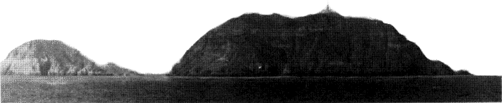
7.2 Jazirat Jalitah (Ile de la Galite) (37°32'N, 8°56'E) lies 21 miles NNW of Cap Serrat (37°14'N, 9°13'E) and is the largest island of a group which rises from Banc de Jalitah (Banc de la Galite). The group is separated from the coast of Tunisia by Canal de la Galite (Canal Jalitah).
Jazirat Jalitah has steep shores and its W part rises to Bout de Somme (Grand Sommet), 391m high, which is surmounted by a yellow lookout tower. Piton de l’Est, a conspicuous conical peak, is 360m high and stands near the SE extremity of the island. Two radio masts stand close S of the middle of the island and are very conspicuous when approaching from the S.
A small fishing harbor lies on the S side of the island. In good weather, temporary anchorage can be obtained by small vessels, with local knowledge, within small bays on the N and S sides of Jazirat Jalitah.
Galitons de l’Ouest consists of two islets lying 1.5 miles SW of Jazirat Jalitah. Galiton, 158m high, is the larger of the two. A light is shown from a structure, 14m high, standing on its summit.
La Fauchelle, close SE of Galiton, is 137m high and dominated by L’Aiguille, a conspicuous cone at its SE end.
Galitons de l’Est consists of three rocks named, from N to S, Gallo, Pollastro, and Gallina. Gallo, 119m high, is the largest and lies 1 mile NNE of the N extremity of Jazirat Jalitah. Shoals, with a least depth of 6m, lie within 1 mile of Gallo.
 |
Jazirat Jalitah – Galiton de l’Ouest from N |
Ecueil des Sorelles (37°24'N, 8°36'E), consisting of two shallow rocky patches, lies 14 miles WSW of Galitons de l’Ouest. A lighted buoy, fitted with a racon, is moored close W of the W patch and a buoy is moored close E of the E patch. A concrete block, 2m high, stands on the W patch. A depth of 14.6m was reported (1970) to lie about 3 miles N of this block.
Banc des Mazzarilles, which is rocky and has depths of 21 to 49m, lies about 8 miles N of Jazirat Jalitah.
A depth of 6.1m was reported (1994) to lie in the vicinity of Banc des Spiss, 15 miles N of Jazirat Jalitah.
Caution. – The buoys marking Ecueils des Sorelles should not be relied upon because of their exposed positions.
Vessels have experienced strong currents in the vicinity of Ecueils des Sorelles.
Cap Matifou to Golfe de Bejaia
7.3 Cap Matifou (Bourdj el Bairi) (36°49'N, 3°14'E), the E entrance point of Baie d’Alger, is the W extremity of a low headland. The N side of the headland is cliffy and extends E for 1.7 miles. The E part rises to a flat-topped hill, which from a distance appears as an island.
A light is shown from a structure, 11m high, standing 1 mile E of the cape. A signal station and two pylons stand close NNW and 0.5 mile W, respectively, of the light.
A spit extends about 0.5 mile W from the cape and is marked by a lighted buoy.
Banc de Matifou (36°51'N, 3°14'E), with a least depth of 9m, lies about 2.2 miles N of the cape. Strong currents are experienced in the vicinity of this shoal bank and vessels should avoid passing over it.
Iles Sandja, a group of rocks, lies about 0.8 mile NE of Cap Matifou Light, with the largest being 13m high. Vessels should not attempt to pass between this group and the coast. Bordelaise, a shallow rock, lies about 1.5 miles offshore, 2.5 miles E of Cap Matifou Light. Several rocks and shoals lie between this rock and the coast.
Ain Taya, a village, is situated 2.5 miles SE of Cap Matifou Light. Small vessels, with local knowledge, can obtain anchorage, sheltered from W winds, off this village.
Ilots Agueli, a group of small islets, lies about 0.7 mile offshore, 5 miles ESE of Cap Matifou Light. The largest islet is 25m high and is marked by a beacon. Anchorage can be obtained, by small vessels with local knowledge, close E of the middle of the largest islet. The berth is in depths of 12 to 14m, rocky bottom, off a conspicuous cave. A sandy bottom can be found farther offshore, but the position is less sheltered.
Draa Ed Dar, a hill, stands 2 miles SE of Ilots Agueli. It is 71m high and prominent. A conspicuous group of buildings stands on a wooded hillock near the coast, 2 miles E of this hill.
7.4 Cap el Achaichi (36°47'N, 3°31'E), a headland, is located 14.2 miles ESE of Cap Matifou, at the N extremity of a chain of mountains. The most conspicuous summits of the chain are Djebel Bou Arous, 444m high, and Mont Sidi Feredj, 452m high, which stand about 4 miles SE of the headland. From the NW, these summits appear like a saddle, while from the NE, they appear as two sharp peaks.
A small craft harbor, protected by two moles, lies on the SW side of a point, 2.3 miles ENE of Cap el Achaichi.
Cap Djenet, located 11.5 miles NE of Cap el Achaichi, is high. A prominent hill, 438m high, stands 1.5 miles SE of the cape.
Baie Mersat Djenet is entered close SW of Cap Djenet and affords temporary anchorage, sheltered from E winds, to small vessels with local knowledge.
Djebel Bou Berak, a conspicuous mountain, stands 5.5 miles E of Cap Djenet. It is conical in shape and 593m high.
Cap Bengut (36°55'N, 3°54'E), located 8.7 miles ENE of Cap Djenet, is easy to identify from seaward. It lies at the E extremity of the above-mentioned mountain chain and, on certain bearings, appears saddle-shaped. A reef extends 0.1 mile NNW from this cape. A light is shown from a tower, 29m high, standing on the cape.
Pointe de Dellys, located 1.2 miles ENE of Cap Bengut, is high, narrow, and fringed by a spit. A light is shown from a structure, 8m high, standing on the point.
Caution. – Vessels should not approach the coast within depths of less than 37m between the small port of Dellys and Cap Sigli (36°54'N, 4°46'E).
7.5 Dellys (36°55'N, 3°55'E) (World Port Index No. 45560), a small port, lies in the W part of a bay which is entered close E of Pointe de Dellys.
Depths – Limitations. – The main commercial facilities include Berth No. 1, situated on North Quay, which is 107m long and has a depth of 6m alongside, and Berth No. 4, situated on South Quay, which is 129m long and has a depth of 5.5m alongside. Generally, vessels up to 100m in length and 5.5m draft can be accommodated. In addition, ro-ro vessels up to 105m in length can be handled.
Aspect. – The port is protected from the E by a breakwater which extends SSE from a point lying 0.5 mile SW of Pointe de Dellys.
A mosque, which stands close W of the harbor, is clearly visible when approaching from the E. The town is situated along the S part of the bay.
Pilotage. – Pilotage is compulsory and available during daylight only. The port can be contacted on VHF channel 10, 11, 12, 13, 14, or 16. Vessels should send an ETA 24 hours in advance of arrival. Messages may be sent through Alger Radio (7TA). Pilots board within the anchorage area.
Anchorage. – The roadstead off the harbor is sheltered from W and NW winds and the holding ground is good. Anchorage should be obtained, in depths of 13 to 24m, about 0.2 mile SSE of Pointe de Dellys.
7.6 Arbane Millia (36°54'N, 4°03'E), a rock, lies close inshore, 6.7 miles E of Dellys. It is large, white, and over 30m high.
Tala Aicha, 890m high, stands 3.5 miles S of the rock. This mountain is conspicuous and has a crater-like summit.
Pointe Tigzirt, located 3.2 miles E of Arbane Millia, is fronted by an islet and a reef which lie within 0.5 mile of it. The point can easily be identified by the red roofs of the houses in a village which is situated in the vicinity. Small vessels, with local knowledge, can obtain anchorage, sheltered from E winds, under the lee of this point.
Cap Tedles (36°55'N, 4°10'E), located 1.7 miles ENE of Pointe Tigzirt, is 250m high and rounded. A mountain, 843m high, stands 3.7 miles S of the cape; its summit is surmounted by a remarkable clump of trees.
Sidi Khaled, a point of land, is located 1 mile E of Cap Tedles and surmounted by a mosque. Roches Sidi Khaled, formed by several rocks and shoals, extends up to 0.7 mile NE from the point. Small vessels, with local knowledge, can obtain anchorage, sheltered from W winds, under the lee of these shoals, but the holding ground is poor.
Pointe de Timliline, located 5 miles E of Cap Tedles, is dominated by two prominent hills, 281m and 283m high. Pointe de Mers el Farm is located 8.5 miles E of Cap Tedles, and several rocks, awash, and shoals lie up to 1 mile offshore.
Azeffoun, fronted by a small jetty, lies in the SE part of the bay, which is entered between Pointe de Mers el Farm and Cap Corbelin, 4.5 miles ESE. Anchorage, sheltered from E winds, can be obtained by vessels, with local knowledge, in depths of 7 to 10m, W of the jetty.
Cap Corbelin (36°55'N, 4°26'E), reddish -yellow in color and prominent, is the NW extremity of a mountainous projection. From seaward, there appears to be a deep bay lying to the E of the cape because the land on that side is very low. A light is shown from a tower, 13m high, standing on the cape.
Tamgout, a mountain, stands 5.5 miles S of the cape. It is 1,278m high and very conspicuous from seaward.
7.7 Cap Sigli (36°54'N, 4°46'E) is located 16 miles E of Cap Corbelin and is fringed by rocks. This cape is only prominent from close inshore either to the E or W of it. A light is shown from a structure, 26m high, standing on the cape.
Between Cap Sigli and Cap Carbon, 18 miles ESE, the coast is fronted by rocks. Temporary anchorage can be obtained, in a depth of 12m, by vessels, with local knowledge, within a bay which is entered 3 miles ESE of the cape.
Djebel Mindjou, 672m high, is located 1.8 miles S of Cap Sigli; some prominent rocky outcrops, which resemble ruins, stand on its summit.
Djebel Arbalou, 1,317m high, stands 10 miles SSE of Cap Sigli and dominates this stretch of the coast. From the NW, its summit appears conical, but from other directions it appears rounded.
El Euch, a rocky islet, lies close inshore, 1.5 miles ESE of Cap Sigli. It is reddish -yellow, 33m high, and has a small rock at its N end.
Pointe Boulima (36°49'N, 4°59'E), reddish in color, is located 12 miles ESE of Cap Sigli. This point lies at the E end of a sandy beach and has a small, natural boat harbor on its W side. Ile Pisan, 31m high, lies 0.6 mile NE of Pointe Boulima and is fringed by rocks. Rochers des Moules, 1m high, lies 0.7 mile offshore, 1.5 miles NW of Pointe Boulima.
Pointe Mezaia, located 1.5 miles SE of Pointe Boulima, is surmounted by a conical hill and is joined to the mainland by a ridge of sand. From certain directions, it appears as an islet.
Cap Carbon (36°47'N, 5°07'E), located 4.5 miles ESE of Pointe Mezaia, is dominated by a small conical hill, 220m high. A light is shown from a structure, 10m high, standing on the summit of the conical hill. Another light is shown from a structure, 8m high, standing at the foot of the cliffs on the N side of the cape.
Djebel Gouraya, 660m high, stands 1 mile WSW of the cape and is surmounted by a prominent fort and a signal station.
Golfe de Bejaia (Golfe de Bougie)
7.8 Golfe de Bejaia is entered between Cap Carbon and Ras Afia, 28 miles E.
The S shore of the gulf is dominated by a mountain chain. Dejbel Ta Babor, 1,969m high, is the highest and stands 7 miles inland, 23 miles SE of Cap Carbon. This mountain appears flat-topped and isolated when seen from NW or NE, but from the N, it can only be distinguished from the others by its height and by a small spur on its W side.
Dar Mohand stands close to the coast, 4.7 miles S of Cap Carbon. It is detached and 305m high.
Pointe Aokas, located 8 miles ESE of Dar Mohand, is dominated by a hill, 467m high, which has sides falling steeply to the sea.
Ile Mansouria is the outermost of a group of rocks which lie about 0.5 mile offshore, 12 miles ENE of Pointe Aokas. A light is shown from a structure, 6m high, standing on its N side.
Cap Cavallo (Ras Talou), located 23 miles E of Cap Carbon, is the extremity of a chain of high conical hills which are separated by deep valleys. Grand Cavallo, an islet, lies 0.5 mile offshore, 0.7 mile NE of the cape. It is 52m high and is covered with brushwood. Petit Cavallo, another islet, lies 0.2 mile offshore, 2.6 miles NE of Grand Cavallo. It is flat and surrounded by reefs.
Ilot Hadjret Tafalkout, 17m high, lies 1.1 miles WSW of Cap Cavallo and is the outermost of several dangers in this vicinity. A light is shown from a structure, 5m high, standing on this islet.
Ras Afia (36°49'N, 5°42'E) is located 5 miles NE of Cap Cavallo. A light is shown from a tower with a dwelling, 14m high, standing on this point.
Banc des Kabyles, with a least depth of 7m, lies 3.2 miles NW of Ras Afia and the sea breaks on it in bad weather. Ecueil de la Salamandre, with a least depth of 4m, lies 2 miles NNW of Ras Afia. Both of these dangers are frequently marked by tide rips.
Golfe de Bejaia contains no safe anchorage for large vessels except at Bejaia.
World Port Index No. 45550
7.9 The port of Bejaia, formerly known as Bougie, lies on the W side of Golfe de Bejaia and is principally a crude oil loading terminal.
Port of Bejaia Home Page http://www.portdebejaia.com.dz
Tides – Currents. – Tides are negligible. The water level may rise with S winds and decrease with N and E winds; the difference to the level does not exceed 0.5m.
A rather strong countercurrent is usually found setting N through the roadstead. However, after heavy gales the current flows along the shore of the gulf in a direction contrary to that of the gale, although at the onset of the gale the current flows with it.
Depths – Limitations. – The harbor is protected by two breakwaters and is divided into three basins. The E breakwater extends S and is 0.4 mile long. The W breakwater extends ENE, NNE, and NE and is 1.3 miles long. The entrance fairway is 320m wide and has been dredged to a depth of 13.5m.
The two inner basins are entered from the SW side of the outer basin through a passage, 80m wide. These basins have 2,700m of total commercial quayage with depths of 5.5 to 13m alongside. There are facilities for general cargo, ro-ro, and bulk vessels. Vessels up to 10,000 dwt and 9m draft can be accommodated.
The outer basin has three oil berths with depths of 11.5m, 12.5m and 13.5m alongside. Tankers up to 260m in length and 13m draft can be accommodated.
Aspect. – The city appears as an amphitheater amid green vegetation and contrasts with the high land mass close N.
Marabout of Sidi Yahia, a conspicuous building with a chimney at its W end, stands near the shore, 0.3 mile W of the root of the E breakwater.
A conspicuous chimney stands 2 miles SW of Marabout of Sidi Yahia. A light is shown from a structure, 15m high, standing at the head of the E breakwater.
A lighted buoy is moored about 0.5 mile SSW of the head of the E breakwater and marks the SW end of the dredged entrance channel.
Pilotage. – Pilotage is compulsory. Tanker vessels should send an ETA at least 48 hours and 24 hours in advance to SONATRA, Bejaia through Alger (7TA). A corrected ETA should be sent if more than 1 hour different from previous estimates. Other vessels should send an ETA 6 hours in advance, but 12 hours if arriving at night. Pilots can be contacted on VHF channel 10, 12, 14, or 16 and generally board about 1 mile NE of the E breakwater.
Pilots for the small port of Jijel are also available.
Anchorage. – Anchorage, sheltered from all winds except those from between the NE and E, can be obtained as convenient, in depths of 10 to 20m, off the breakwaters. The bottom consists of mud and sand and the holding ground is good where the mud is hard, but poor where it is soft.
Caution. – A danger area, the limits of which are shown on the chart, lies centered 0.5 mile ESE of the root of the W breakwater. The danger area is marked by a buoy.
Several wrecks, some dangerous, lie in the approaches to the harbor and may best be seen on the chart.
Between December and March, a heavy swell sometimes enters the harbor, usually during and after prolonged NW winds. This causes violent surging and may require vessels to put to sea.
Vessels should not pass close to the breakwater heads. A wave recorder buoy is moored about 0.8 mile E of the head of the E breakwater.
7.10 Jijel (Djidjelli) (36°50'N, 5°47'E) (World Port Index No. 45530), a small port, lies 4 miles E of Ras Afia and is protected by breakwaters.
Depths – Limitations. – The N breakwater extends E from the E extremity of a small peninsula, which is located close N of the town, to an islet and then SSE. The S breakwater extends NE from a mole. The approach channel has a width of 120m and depths of 10 to 11m.
The harbor has 670m of total commercial quayage with depths of 4.3 to 7.3m alongside. There are facilities for general cargo, ro-ro, and fishing vessels. Vessels up to 153m in length and 7m draft can be accommodated.
Aspect. – Mezritane, 388m high, stands 1.2 miles SE of Ras Afia. This hill is prominent and its summit is surmounted by a tower.
The most conspicuous landmarks include the square tower of the town hall; the large white hospital building which overlooks the town; the belfry of a church and a water tower standing in the S part of the town; and a factory building situated 2 miles WSW of the harbor.
A light is shown from a structure, 12m high, standing on the islet at the E end of the N breakwater.
Pilotage. – Pilotage is not compulsory and pilots are available as required from Bejaia. Vessels should send an ETA and request for pilot directly to the pilot station at Bejaia at least 24 hours in advance. The port can be contacted by VHF. Pilots generally board in the vicinity of the harbor entrance.
Anchorage. – Anchorage is available, in depths of 21 to 36m, between 0.5 and 1 mile from the N breakwater.
Caution. – The water level within the harbor sometimes varies up to 0.5m, especially during March and April.
The N sides of the peninsula and the N breakwater are fringed with rocks and shoals and should be given a wide berth.
Winds from the NW may raise surf within the harbor. Berthing becomes difficult and cargo handling is frequently interrupted.
7.11 Jenndjene (Jen Jen) (36°49'N, 5°53'E) lies about 5 miles E of Jijel.
Port of Jen-Jen Home Page http://www.djendjen-port.com.dz
The facilities include a general cargo quay, 760m long; a mixed cargo quay, 250m long; and a ro-ro quay, 76m long. There are depths of 11m alongside. In addition, there is a steel product quay, 1,060m long, with depths of 10.5 to 18m alongside.
This port accommodates cargo vessels up to 30,000 dwt and ore vessels up to 120,000 dwt.
Pilotage is compulsory. The pilot can be contacted on VHF channel 12 and boards in position 36° 51’N, 5° 54'E
Vessels should provide an ETA 72 hours in advance of arrival. The ETA should be confirmed 2 hours prior to arrival on VHF channel 14 or 16.
7.12 Ilot Tazerout (El Hadjra) (36°52'N, 6°04'E), 13m high, lies close off a point, 14.2 miles ENE of Jijel. Several reddish and prominent sandhills, 88m high, stand close inland within 3 miles W of this islet.
Conspicuous hills along this part of the coast include Djebel Bou Kertzoum, 148m high, standing 3 miles SE of Jijel; El Koudiat, 112m high, standing 6 miles ESE of Jijel; and Djebel Seddets, 956m high, standing 5 miles SSW of Ilot Tazerout.
Haut-Fond de Jijelar, a bank with a depth of 25m, lies about miles NE of Jijel.
Ilot Lamein, 10m high, lies close off a point, 11 miles NE of Ilot Tazerout. Casabianca is situated 1.5 miles SE of Ilot Lamein. Anchorage, sheltered from N and E winds, can be obtained by vessels with local knowledge, in depths of 14 to 26m, about 0.3 mile off the beach at Casabianca.
7.13 Ras Atia (Moghreb) (37°01'N, 6°16'E) is located 2.5 miles NNE of Ilot Lamein. A light is shown from a structure, 15m high, standing on the point.
Mersa Damous, a cove, lies 2.3 miles ENE of Ras Atia and is marked by some houses, with red roofs, standing on a cliff on its W side. A conspicuous ravine is located at the head of this cove.
Cap Bougaroun (Cap Bougaroni) (Ras Seba Rous) (37°05'N, 6°28'E) is located 10.5 miles ENE of Ras Atia and is the N extremity of a mountainous promontory which lies between Ilot Lamein and Collo. A light is shown from a structure, 10m high, standing on the cape. A signal station is situated close E of the light.
Ras el Kbiba, a small peninsula, lies 4.5 miles SE of the cape. Baie de Tamanert and Baie des Beni Said, two small bays, are entered NW and SE, respectively, of this peninsula. Bar en Nsa, a cove, is entered between the S entrance point of Baie des Beni Said and Cap Collo, 1 mile SE.
Good anchorage, with W winds, can be obtained by vessels, with local knowledge, in a depth of 14m within Baie de Tamanert. Anchorage can also be obtained by vessels, with local knowledge, within Baie des Beni Said, but care should be taken to avoid a shallow reef which lies about 600m from the head of the bay.
Temporary anchorage can be obtained, in a depth of 20m, in the central part of Bar en Nsa.
Pointe Djerda (Cap Collo) (37°01'N, 6°35'E) is the NE extremity of Presqu’ile Djerda, a small peninsula. A light is shown from a structure, 11m high, standing on the cape. A shoal, with a depth of 22m, lies about 0.5 mile NE of the cape.
7.14 Collo (37°00'N, 6°35'E) (World Port Index No. 45520), a small port, lies on the NW side of Baie de Collo, which is entered between Cap Collo and Ras Frao (Kharras), 3.2 miles SE.
Depths – Limitations. – The harbor is protected by a jetty, 145m long, which extends S from a point close S of the town. There is 238m of total quayage, with depths of 4.2 to 5m alongside.
Aspect. – The town is situated at the root of the peninsula. Koudiat Djezair, 99m high, stands close S of the town and is surmounted by a small but conspicuous fort.
Sidi Achour, a prominent shrine, surmounts the summit of a hill, 536m high, standing 2 miles W of Cap Collo.
Pilotage. – Pilotage is not compulsory, but is advised for vessels without local knowledge. Private pilots are available.
Anchorage. – Baie de Collo is one of the best open roadsteads on the coast of Algeria. It affords excellent shelter from W and N winds. Large vessels should anchor, in a depth of 27m, about 0.4 mile SE of the town. The holding ground is mostly excellent. Small vessels can obtain anchorage, in depths of 6 to 10m, about 100m from the shore.
7.15 Kharras (Ras Frao) (36°58'N, 6°38'E), the SE entrance point of Baie de Collo, is dominated by Morne Telezza, an isolated and conical hill, 125m high.
Ras Rdeb (Ras Erded) is located 2.5 miles ESE of Ras Frao. Ile Mta, an islet, lies about 0.5 mile offshore, 1 mile E of the point. It is 62m high, but is not easy to distinguish from the coast.
Ras el Kal’a (Ras Bibi) is located 3 miles E of Ras Rdeb. Ilot Bibi (Kal’a Rdjel el Klou), an islet 46m high, lies 0.5 mile WNW of this point.
Pointe des Sept Freres is located 1.7 miles ESE of Ras Bibi; a chain of small islets extends up to 0.3 mile NNW of it.
Point Esrah (Pointe Asra), located 4.5 miles E of Ras Bibi, is fringed by islets. A spit, with a depth of 4.7m, extends up to about 0.3 mile N of the point. Baie d’Esrah is entered between Point Esrah and Cap Akmes, 2 miles SE. A prominent building, with a red roof, stands at the head of this bay.
Ile Sridgina (Ile Srijina) (36°53'N, 6°53'E), lying 0.3 mile NE of Cap d’Akmes, is 48m high and surrounded by rocks and shoals. A light is shown from a structure, 12m high, standing near the middle of this islet.
Cap Est is located 0.9 mile SSE of Cap d’Akmes. Ile du Lion, with a small islet lying close ENE of it, lies close NE of the cape. It is 31m high and is marked by a light.
Rocher du Lazaret, a small island less than 1m high, lies about 0.1 mile offshore, 0.5 mile S of Cap Est. Ilot des Singes is located on the NW side of Baie de Stora, 0.8 mile S of Cap Est. This islet lies close inshore and is connected to the mainland by a bridge. A light is shown from a structure, 9m high, standing on the islet.
Stora, a village, is situated at the head of the bay, 0.3 mile SSW of Ilot des Singes. A small harbor lies E of the village and is protected by breakwaters.
Caution. – A prohibited anchorage area, the limits of which are shown on the chart, extends NE from the vicinity of Ilot des Singes.
Skikda (Philippeville) (36°53'N, 6°55'E)
World Port Index No. 45510
7.16 The port of Skikda lies at the head of Golfe de Stora (Golfe de Philippeville), 3 miles SSE of Ile Sridgina (Ile Srijina).
Port of Skikda Home Page http://www.skikda-port.com
Port Methanier, an oil and LNG terminal, has been constructed 1.7 miles E of Skikda.
Winds – Weather. – During bad weather, heavy seas frequently roll into the gulf. With NW winds, heavy seas set onto the shore between Stora and Skikda. Strong NW winds have been reported to cause an undertow.
Tides – Currents. – Winds from the W raise the level of the water in the harbor and winds from E lower it. The difference may be as much as 0.3m.
Depths – Limitations. – The harbor at Skikda is protected by a breakwater which extends 0.8 mile WNW from the vicinity of Cap Skikda. Two commercial basins have berths with depths of 6 to 10m alongside and facilities for bulk, general cargo, ro-ro, and fishing vessels. Three tanker berths are situated on the S side of the breakwater and have depths of 11 to 13m alongside. Tankers up to 230m in length and 13m draft can be accommodated.
At Port Methanier, the harbor is protected by two breakwaters. The W and outer breakwater extends 1 mile N and NE from the shore. The E breakwater extends 0.3 mile NW from a point on the shore lying 0.6 mile E of the root of the W breakwater. The entrance fairway is dredged to a depth of 18m.
There are two LNG berths which can handle vessels up to 90,000 cu.m. and 11.5m draft. An LPG berth can handle vessels up to 40,000 cu.m. and 10.5m draft. There are three oil berths with depths of 14 to 16m. Tank vessels up to 265m in length and 14.8m draft can be accommodated.
Aspect. – Cap Skikda is located 2 miles SE of Ilot des Singes. It is surmounted by a white prominent villa with a staircase descending to the sea.
The breakwater at Skikda, situated close W of Cap Skikda, is 9m high and conspicuous. A bridge, with several arches, crosses the mouth of Oued Safsaf, close E of Cap Skikda.
Port Methanier, the new port, is situated close E of Cap Skikda. A conspicuous flare is situated close S of the harbor and several prominent tanks and chimneys stand along the shore in the vicinity of the port.
Lights are shown from structures standing at the heads of the breakwaters at Skikda and Port Methanier.
The entrance fairway is indicated by a lighted range.
Pilotage. – Pilotage is compulsory for vessels of 500 grt and over. Pilots can be contacted on VHF channel 12, 14, or 16 and board vessels bound for Skikda at the anchorage or about 1 mile N of the entrance. Vessels bound for Port Methanier are generally boarded about 1 mile N of the head of the W breakwater.
Regulations. – Vessels should send an ETA 72 hours and 48 hours in advance, with a confirmation 24 hours prior to arrival.
Anchorage. – The roadstead anchorage for the port of Skikda affords good protection from W winds, but not from NW winds. In good weather, large vessels can obtain anchorage, in depths of 16 to 18m, sand, about 0.5 mile SE of Ilot des Singes. In winter, large vessels should anchor, in depths of 20 to 25m, farther offshore.
An anchorage designated for tankers lies, in depths of 30 to 40m, about 1 mile NW of the W breakwater at Port Methanier. The holding ground is good.
Other vessels can anchor in the vicinity of position 36°55.4'E, 6°55.6'E Vessels should not obstruct the approaches and entrances to the harbors.
Caution. – Large vessels should not pass close to the heads of the breakwaters at Skikda or Port Methanier, as they are not steep-to.
When the swell in the roads reaches a height of 2m, an undertow, which makes remaining alongside very difficult, develops at the berths within Port Methanier.
A wave recorder buoy is moored about 0.6 mile WNW of the head of the W breakwater at Port Methanier.
7.17 Ras Filfila (Felfelah) (36°55'N, 7°06'E), located 8 miles ENE of Port Methanier, is formed by rocky cliffs and has a conical rock, 35m high, standing on its NE side. Small vessels, with local knowledge, can obtain anchorage in a creek on the E side of this point.
Oued el Kebir flows into the sea 9 miles NE of Ras Filfila, and its mouth is conspicuous when approaching from the W.
Pointe de Sidi Bou Merouane, located 1.5 miles N of the Oued el Kebir, is fringed with foul ground. El Mersa Light is shown from a structure, 5m high, standing close S of the point. Anchorage, somewhat sheltered by the point, can be obtained by vessels with local knowledge in this roadstead, but the NW part is encumbered with rocks.
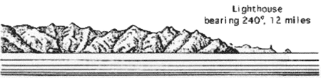
7.18 Cap de Fer (37°05'N, 7°10'E), located 17 miles NE of Skikda, is one of the most salient capes on the coast of Algeria; the high land SE of it is very conspicuous. A light is shown from a tower, 17m high, standing on the cape. A signal station is situated near the light.
 |
Cap de Fer Light bearing 120 °, distant 7 miles |
 |
Cap de Fer from ENE |
A rocky islet, with some rocks close W of it, lies about 0.2 mile W of the cape.
In winter, strong currents are experienced off the cape and with WNW winds, there is frequently a heavy swell.
Large vessels can obtain good shelter from E winds in positions S of the cape and about 0.7 mile offshore. Depths of 30m are available for anchorage. The bottom is mostly formed of mud, shells, and coral, with rocks and gravel in places.
The coast between Cap de Fer and Cap Takouch, 10.5 miles E, is fringed with rocks and shoals extending about 0.5 mile offshore in places.
Baie de Sidi Akkacha, entered 5 miles E of Cap de Fer, affords anchorage, sheltered from E winds, to vessels with local knowledge. Several above-water rocks lie within 0.5 mile of its E entrance point, which is surmounted by Sidi Akkacha, a conspicuous white shrine.
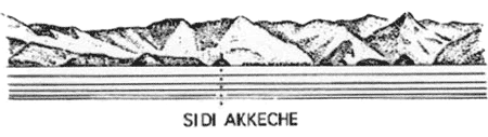 |
Shrine of Sidi Akkacha |
7.19 Cap Takouch (37°05'N, 7°24'E) is the NE extremity of a small multi-headed peninsula. A light is shown from a tower, 10m high, standing on the summit of a hill, 0.4 mile SSE of the cape. Sidi Merkeb, a conspicuous white shrine, stands 0.2 mile SSW of the light. Ile Djezira, the outermost and largest of two islets almost joined to the coast, lies close NE of the light. Ile Takouch, 33m high, lies 1 mile offshore, about 2.7 miles W of the cape.
Seiche du Cap Takouch, a rocky shoal plateau, lies about 2 miles N of the cape. It has a least depth of 13m and is dangerous for deep-draft vessels.
A current, with a rate up to 2 knots, has been experienced on the bank lying between Seiche du Cap Takouch and the coast. In bad weather, the sea over this bank is especially heavy and vessels should avoid passing over it.
Sidi Yahia, 545m high, stands 2 miles SSW of Cap Takouch. This conical mountain is prominent and surmounted by a mar-about tower.
Sidi Benout, 538m high, stands 0.7 mile inland, 4 miles SE of Cap Takouch. This conical mountain is flat-topped and surmounted by a white marabout tower.
Baie de Takouch lies between Ile Djezira and La Pointe Percee, 2 miles SSE. Mersa Takouch (Chetaibi) (37°04'N, 7°23'E) (World Port Index No. 45500), a village, stands at the head of the bay and is fronted by a small harbor formed by two jetties extending S from the shore. A quay, 125m long, is situated between these jetties and has depths of 5 to 6m alongside. Excellent shelter from W winds can be obtained in this bay, but NE and E winds send in a heavy sea and swell. Anchorage can be obtained, in depths of 10 to 20m, W of the village church.
Cap Matfouch (Cap Akeine), located 6 miles SE of Cap Takouch, is reddish and dominated by a hill, 571m high. Roche Akeine, marked by a light, lies 0.5 mile N of the cape. It has several rocky heads, one of which is awash.
Sidi Bou Zeid, a shrine, surmounts a coastal hill, 4 miles SSE of Cap Matfouch. It is conspicuous when not hidden by the trees. A prominent chimney stands in a village at the bottom of the hill.
Cap du Pain de Sucre, located 4.5 miles E of Sidi Bou Zeid, is a conspicuous feature. It has a rocky crest, 521m high, and terminates in a pyramidal hill, 152m high.
Voile Noire, a rock, lies close inshore, 1 mile SE of the cape. It is conical and 65m high.
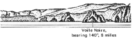 |
Voile Noire from NW |
7.20 Ras el Hamra (36°58'N, 7°48'E), located 6 miles E of Cap du Pain de Sucre, is the W entrance point of Golfe d’Annaba. When seen from a distance from E or W, this cape appears as an island. It is fringed with rocks and two hills stand near the seaward extremity.
A light is shown from a structure, 14m high, standing 0.5 mile W of the cape. A signal station stands on the summit of a hill, 0.2 mile SW of the light.
Golfe d’Annaba lies between Ras el Hamra and Cap Rosa, 22 miles E. It is easily identified from seaward and, at a distance, appears larger than it really is. The heights descending towards each entrance point are separated, at the head of the gulf, by a low plain, which at some distance inland is backed by detached mountains. A mountainous ridge extends 8.5 miles SW from Ras el Hamra and terminates in a mountain, 1,008m high.
Oued Seybouse flows into the sea on the S side of the port of Annaba, 6 miles S of Ras el Hamra. The depths off the mouth of this river are shoal and liable to change with each rainy season.
Oued Mafragh flows into the sea 10.2 miles SE of Ras el Hamra. Its entrance is the combined mouths of several rivers. A signal station is situated close E of the river entrance.
Djebel Bou Abed, 739m high, stands 10.5 miles SSE of the river entrance and is prominent.
Rocks, with a least depth of 20m, lie 5.5 miles NE and 7.5 miles ENE of the river entrance.
An aeronautical light is reported to be occasionally shown from a position 4.7 miles SSW of the river entrance.
Between the entrance of Oued Mafragh and Cap Rosa, 15 miles ENE, the coast consists of a succession of cliffs, 49 to 101m high.
Annaba (Bone) (36°55'N, 7°46'E)
World Port Index No. 45490
7.21 The port of Annaba lies on the W side of Golfe d’Annaba, 4 miles S of Ras el Hamra.
Port of Annaba Home Page http://www.annaba-port.com
Tides – Currents. – There is a variation in the water level that sometimes amounts to 0.4m above and below mean sea level.
Depths – Limitations. – The harbor consists of three basins and is protected by two breakwaters, Jetee du Lion and Jetee Sud (Quai Sud).
There is 3,985m of total commercial quayage, with depths of 4 to 13m alongside, and facilities for general cargo, bulk, and ro-ro vessels. In addition, there are three tanker berths, with depths of 7 to 13m alongside. Vessels up to 250m in length and 11.5m draft can be accommodated. Tankers up to 11.9m draft can be handled.
Aspect. – Fort Genois stands on a rounded point, 1 mile SSW of Ras el Hamra Light. A light is shown from a structure, 8m high, standing close WSW of the fort.
Baie du Lazaret and Baie des Caroubiers lie close SSW and 1.5 miles SSW, respectively, of the fort.
A group of four conspicuous buildings stand 1.2 miles NW of the harbor entrance. The prominent Basilica of Saint Augustin stands 2 miles SW of the harbor entrance.
A stranded wreck, conspicuous visually and on radar, lies about 0.4 mile offshore, 5 miles SE of the harbor entrance.
Pilotage. – Pilotage is compulsory. Pilots may be contacted on VHF channel 14 and generally board about 0.5 mile E of the harbor entrance. During strong E winds, embarkation of the pilot may be difficult. Vessels should send an ETA through Annaba (7TB).
Anchorage. – Anchorage can be obtained, in depths of 20 to 22m, within Baie du Lazaret and S or SSW of Fort Genois. Anchorage can also be taken in Baie des Caroubiers, but it is not as safe.
Caution. – Rocks, with a depth of 13m, lie about 1.5 miles E and 3.5 miles ESE of the harbor entrance. A rock, with a depth of 8m, lies about 2.7 miles SE of the harbor entrance. A dangerous wreck lies about 1.5 miles S of the harbor entrance. With NW gales, heavy seas are experienced off the harbor entrance. Sections of submarine cable may still exist within a former prohibited anchorage area in the S part of Baie des Caroubiers.
7.22 Cap Rosa (36°57'N, 8°14'E) is rocky, covered with brushwood, and dominated by Djebel Karoussa, 247m high. Its W side is faced with reddish cliffs. A light is shown from a tower with a dwelling, 13m high, standing on the cape.
Rocher du Schiavone lies close off a point, 1.5 miles SE of Cap Rosa. It is conical in shape and 35m high.
Baie du Grande Canier and Baie du Petit Canier lie NW and SE, respectively, of Rocher du Schiavone. These bays afford fairly good shelter to vessels with local knowledge from winds between the W and WNW, but both are open to the NE.
Cap Gros is located 8 miles ESE of Cap Rosa. This cape is easily identified as it rises to Kef el Alem, 235m high. Kef Trebiche, 256m high, stands 0.9 mile SSW of the cape.
7.23 El Kala (La Calle) (36°54'N, 8°27'E) (World Port Index No. 45480), a small port, lies 1.8 miles SE of Cap Gros and is used by coasters.
Depths – Limitations. – The harbor is divided into two basins. The outer basin has a depth of 4.6m and the inner basin has a depth of 3m. Vessels up to 61m in length and 4.5m draft can enter in good weather.
A small jetty is situated 0.6 mile E of the harbor.
Aspect. – The harbor lies between Point Noire, located 1.7 miles SE of Cap Gross, and Ilot de France, 0.3 mile E. Ilot de France has numerous buildings on it and is connected at its SE end to the mainland by the quays at the head of the harbor. A light is shown from a structure, 8m high, standing on the W end of Ilot de France. Point Noire is 13m high and fronted on its W side by a rock, 11m high. The town of La Calle stands on the S side of the harbor.
Pilotage. – Pilotage is not compulsory. Local knowledge is recommended. The services of a local resident are reported to be available.
Anchorage. – Vessels with local knowledge can anchor within a bay entered NW of Pointe Noire. It affords good shelter from W winds, but with NW winds, a heavy swell rolls in.
Open anchorage can be obtained, in depths of 20 to 26m, sand and gravel, about 0.4 mile N of Ilot de France Light, but the holding ground is poor.
Both of the above anchorages generally become untenable during winds from the NW or NE.
Caution. – The depths in the harbor cannot be relied upon due to silting.
7.24 Monte Rotondo (36°54'N, 8°32'E), 178m high, stands 4 miles E of El Kala. The ruins of a factory with tall chimneys are situated at the foot of this hill.
Cap Roux (36°57'N, 8°37'E), located 8.5 miles ENE of El Kala, can be identified by the reddish cliffs on its W side. The border between Algeria and Tunisia lies about 1.5 miles E of this cape.
Ras Tabarqah (Cap Tabarka) (36°58'N, 8°45'E), located 6 miles ENE of Cap Roux, consists of rugged grey cliffs and is fronted by rocks. A prominent white house stands on a coastal hill, close W of the cape.
Jazirat Tabarqah (Ile de Tabarka) lies 0.2 mile offshore, 0.7 mile ESE of Ras Tabarqah. This island is crowned by a ruined castle and is 95m high. Its N side is faced with steep cliffs and it slopes gently to the S end, where there are some ruins. A light is shown from a structure, 8m high, standing on the ruins of the castle.
The island is connected at its S end to the mainland by a rubble causeway.
A small harbor, situated on the SW side of Jazirat Tabarqah, has silted up.
7.25 Tabarqah (Tabarka) (36°58'N, 8°46'E) (World Port Index No. 45460), a small harbor, is situated on the SE side of the island and protected by breakwaters. It has depths of 2.5 to 4.2m and is mostly used by fishing vessels and yachts.
Anchorage can be obtained E or W of Jazirat Tabarqah, but neither affords good protection, and the holding ground is bad. The W roadstead is somewhat sheltered by the island, but is dangerous in bad weather. In the E roadstead, also known as the summer anchorage, vessels with local knowledge may anchor as convenient.
Djebel Adissa, 889m high, and Djebel Bir, 1,019m high, are both prominent and stand 13 miles S and 11.5 miles SSE, respectively, of Cap Roux.
Djebel Moruna, a rocky hill, stands 3 miles E of Tabarqah. Two conspicuous monuments, 0.2 mile apart, stand on its NE slope.
Djebel Zouara stands 11.7 miles NE of Tabarqah. Its prominent black peak is 218m high. Kef es Sid, 825m high, stands 9 miles SE of Djebel Zouara. Its summit is rocky and resembles a group of ruins.
Cap Negro, located 13.5 miles NE of Tabarqah, is not easy to identify; however, Kef Budmah (Jebel Sidi Mohammed), 474m high, stands 1 mile SE of it and is a good landmark. Anse Budmah lies on the S side of the cape and is sheltered from winds from the NNW through E to S. However, the bottom is mostly rock, the holding ground is only moderately good, and the N side of this bay is fringed with rocks.
7.26 Cap Kavansur (37°08'N, 9°02'E) is located 3 miles NE of Cap Negro. Kef En Nsoor stands 0.5 mile inland, 1 mile E of the cape. It is 330m high and has a conspicuous conical summit. Djebel Zitana (Djebel ech Chitane), 464m high, stands 2 miles E of Kef En Nsoor and is prominent.
Anse de Sidi Mechrig lies 5 miles ENE of the cape and can be identified by a small, rocky point surmounted by a ruin. A conspicuous monument stands on a hill, close SSE of the point. Another hill stands 0.5 mile SE of the monument and is surmounted by a marabout tower.
Cap Serrat (37°14'N, 9°13'E), located 11 miles NE of Cap Kavansur, is fully described in paragraph 8.2.